- Australia ▾
- Topographic
▾
- Australia AUSTopo 250k (2024)
- Australia 50k Geoscience maps
- Australia 100k Geoscience maps
- Australia 250k Geoscience maps
- Australia 1.1m Geoscience maps
- New Zealand 50k maps
- New Zealand 250k maps
- New South Wales 25k maps
- New South Wales 50k maps
- New South Wales 100k maps
- Queensland 10k maps
- Queensland 25k maps
- Queensland 50k maps
- Queensland 100k maps
- Compasses
- Software
- GPS Systems
- Orienteering
- International ▾
- Wall Maps
▾
- World
- Australia & New Zealand
- Countries, Continents & Regions
- Historical
- Vintage National Geographic
- Australian Capital Territory
- New South Wales
- Northern Territory
- Queensland
- South Australia
- Tasmania
- Victoria
- Western Australia
- Celestial
- Children's
- Mining & Resources
- Wine Maps
- Healthcare
- Postcode Maps
- Electoral Maps
- Nautical ▾
- Flags
▾
- Australian Flag Sets & Banners
- Flag Bunting
- Handwavers
- Australian National Flags
- Aboriginal Flags
- Torres Strait Islander Flags
- International Flags
- Flagpoles & Accessories
- Australian Capital Territory Flags
- New South Wales Flags
- Northern Territory Flags
- Queensland Flags
- South Australia Flags
- Tasmania Flags
- Victoria Flags
- Western Australia Flags
- Gifts ▾
- Globes ▾
Dear valued customer. Please note that our checkout is not supported by old browsers. Please use a recent browser to access all checkout capabilities


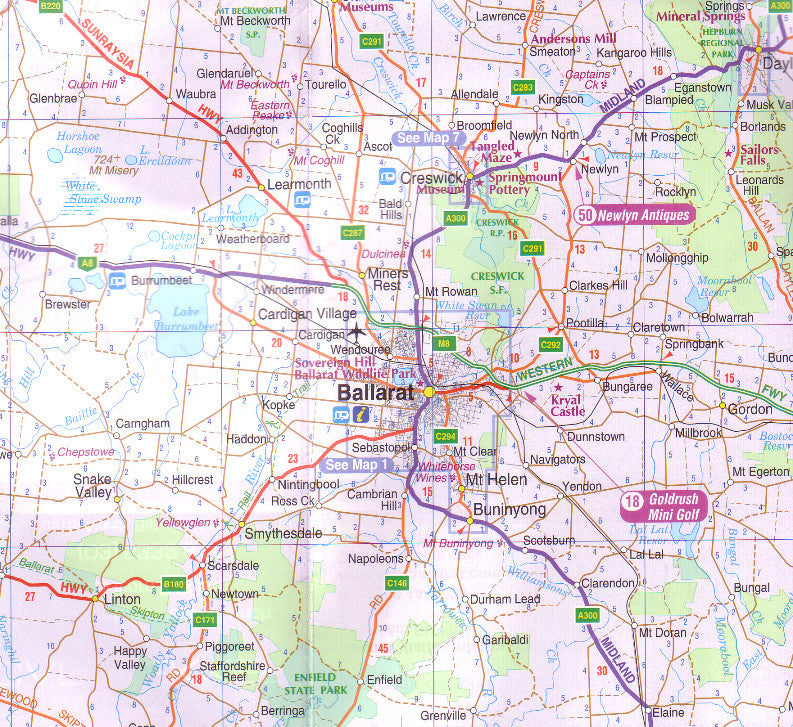
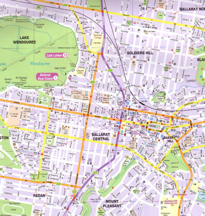
Ballarat Grampians & Spa Country UBD 382 Map
$13.95
Afterpay is only available for orders between $50.00 and $1000.00 More info
Scale: 1:25,000 | Size: 700 mm x 1000 mm | Laminated Option Available
🌄 Explore Victoria’s Diverse Heartland with Confidence and Clarity
From the historic gold rush city of Ballarat, through the rugged beauty of the Grampians National Park, to the soothing mineral springs of Daylesford and Hepburn Spa Country, this UBD 382 Regional Touring Map is your ultimate guide to one of Victoria’s richest and most varied regions.
Designed for road trippers, campers, hikers, and weekend explorers, the map provides exceptional detail, making it perfect for navigating both well-trodden highways and lesser-known country roads. Whether you’re chasing scenic drives, planning outdoor adventures, or indulging in regional culture and heritage, this map ensures you never miss a highlight.
📍 Extensive Regional Coverage
Geographic Boundaries
-
North: Maryborough and Castlemaine, historic towns known for gold rush heritage and charming streetscapes
-
West: Grampians National Park, a stunning natural playground of mountain ranges, waterfalls, and abundant wildlife
-
South: Lismore and Corio, blending rural landscapes with coastal proximity
-
East: Werribee, Sunbury, and Lancefield, gateways to Melbourne’s outer fringes and beyond
This large touring map encompasses major regional centres, key highways, and scenic byways, offering a comprehensive view that caters to all types of travellers.
🏙️ Detailed Town Maps & Indexes
-
Ballarat: Full street map and street index for navigating the city’s rich heritage precincts, arts scenes, and bustling markets
-
Additional Town Maps:
-
Ararat — Gateway to the Grampians
-
Creswick — A quaint town with deep gold mining roots
-
Daylesford & Hepburn Springs — Australia’s premier spa country, perfect for relaxation and wellness
-
Halls Gap — The heart of the Grampians with access to hiking trails and wildlife reserves
-
Kyneton — Known for historic architecture and artisan food trails
-
Stawell — Famous for the Stawell Gift and surrounding natural beauty
-
Woodend — A vibrant town nestled near the Macedon Ranges
-
Each town map includes indexed street names for easy navigation, essential for sightseeing, dining, or accommodation planning.
🌟 Touring Attractions & Points of Interest
Across the map, find a curated list of attractions, including:
-
National and state parks
-
Historic landmarks and museums
-
Wineries and cellar doors
-
Scenic lookouts and walking trails
-
Camping grounds, picnic spots, and caravan parks
-
Local events and festivals (seasonal highlights)
This makes the map more than just a navigation tool—it’s a gateway to experiences that bring the region to life.
🛡️ Durable Lamination – Built for the Road & the Outdoors
Opt for the laminated version for extra durability and practicality:
-
Write & wipe surface: Use whiteboard markers to chart your route or jot notes
-
Compatible with Map Dots: Easily mark visited sites or planned stops without damaging the map
-
Weatherproof & Tear-Resistant: Ideal for outdoor use, camping, and field trips
-
Please Note: Laminated maps are made from previously folded sheets flattened and sealed with an 80-micron gloss laminate, so some original fold lines may be faintly visible
📏 Product Details & Specifications
| Feature | Detail |
|---|---|
| Map Title | Ballarat, Grampians & Spa Country UBD 382 |
| Scale | 1:25,000 |
| Physical Size | 700 mm (width) x 1000 mm (height) |
| Format | Folded paper map; laminated option available |
| Publisher | UBD Gregory's |
| Region Covered | Central & Western Victoria |
| Additional Features | Town maps, street indexes, attraction listings |
🎯 Who Should Use This Map?
-
🚗 Road Trippers & Tourists: Perfect for planning day trips or multi-day tours across the region
-
🥾 Hikers & Outdoor Enthusiasts: Essential for accessing walking trails, camping spots, and national parks
-
🏕️ Caravanners & Campers: Identify caravan parks, rest areas, and fuel stops with ease
-
🏞️ Nature & Wildlife Lovers: Discover natural wonders and protected areas with detailed topographic info
-
🏠 Local Residents & Businesses: Useful for local navigation, property management, and regional planning
-
🎓 Educators & Students: Great teaching tool for geography, local history, and environmental studies
🛒 Ready to Explore?
Whether you’re setting out on a weekend escape, planning a comprehensive touring itinerary, or simply want an accurate and attractive map for your wall or vehicle, the Ballarat, Grampians & Spa Country UBD 382 Map is the perfect choice.
Add this essential regional guide to your collection today—choose the laminated version for added durability on the road, or keep it folded and portable for on-the-go adventures.


