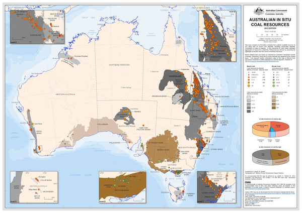
Australia — In-Situ Coal Resources (2012)
National Wall Map • Large / Supermap • Paper / Laminated / Laminated + Hang Rails / Canvas / Canvas + Hang Rails • Printed in Australia
At a Glance (What’s on the Map)
-
⚒️ Coal resources by type: locations and reported in-situ quantities of black and brown coal across Australia
-
🧭 Clear symbology & legend: easy comparison of basins and fields at a national scale
-
🗺️ Wall-readable design: disciplined labels and colour hierarchy for meeting-room visibility
“In-situ” indicates resources as reported within the ground at the time of mapping (2012).
Why This Map Works
-
📊 Quantities visualised clearly — symbol and/or shading conveys relative resource scale at a glance
-
🌏 National context — compare coal provinces side-by-side to understand distribution and scale
-
🧩 Fast orientation — coastline, state boundaries and major basins provide instant geographic context
-
💬 Conversation-ready — ideal for classrooms, briefing rooms, site offices and reception areas
Finishes & Display Options
-
📄 Paper (160 gsm Matte-Coated) — low-glare, crisp; perfect for framing under glass
-
💧 Laminated (True Encapsulation: 2 × 80-micron gloss) — wipe-clean, tear-resistant; compatible with non-permanent whiteboard markers & map dots
-
🪵 Laminated + Timber Hang Rails — lacquered natural timber rails (top & bottom) with top hanging cord
⏱️ Custom finish — please allow up to 10 working days for rail fitting. -
🖼️ Canvas (HP 395 gsm Professional Matte) — gallery-grade canvas + HP pigment-based inks for long-term fade resistance
-
🪵 Canvas + Timber Hang Rails — same premium canvas, finished ready to hang
⏱️ Please allow up to 10 working days for rail fitting.
Tip: Choose laminated if you plan to annotate during briefings.
Sizes
-
Large: 1150 mm (W) × 720 mm (H)
-
Supermap: 1450 mm (W) × 870 mm (H)
📏 Designed for wall readability at typical meeting-room distances.
Specifications
| Field | Details |
|---|---|
| Title | Australian In-Situ Coal Resources Wall Map (2012) |
| Scope | Locations and reported quantities of black and brown coal (in-situ) |
| Date | 2012 edition |
| Formats | Paper • Laminated • Laminated + Hang Rails • Canvas • Canvas + Hang Rails |
| Paper | 160 gsm matte-coated |
| Laminate | 2 × 80-micron gloss (true encapsulation) |
| Canvas | HP 395 gsm Professional Matte |
| Inks | HP pigment-based, fade-resistant |
| Origin | Printed in Australia |
How Teams Use It
-
🏭 Strategy & comms: align executives and stakeholders with a single national snapshot
-
🎓 Teaching & training: visualise coal distribution and scale across Australia
-
🛰️ Context setting: pair with current data decks for time-series discussion
Care & Handling
-
Laminated: Wipe with a dry microfibre cloth (lightly damp if needed)
-
Paper: Frame under glass; avoid moisture
-
Canvas: Dust gently; avoid liquids
Our Commitment
-
🇦🇺 Local craftsmanship: Designed, printed, and finished in Australia
-
🌱 Sustainable materials: FSC® papers + long-life HP pigment inks
-
🎯 Clarity first: colour management and label hierarchy tuned for professional wall readability
-
✔️ Quality assured: Every map is hand-checked, securely packed, and shipped with care
A clear national view of Australia’s coal endowment, at a glance.
Choose your size and finish, add to cart, and we’ll deliver a boardroom-ready centrepiece built to last.


