- Australia ▾
- Topographic
▾
- Australia AUSTopo 250k (2025)
- Australia 50k Geoscience maps
- Australia 100k Geoscience maps
- Australia 250k Geoscience maps
- Australia 1:1m Geoscience maps
- New Zealand 50k maps
- New Zealand 250k maps
- New South Wales 25k maps
- New South Wales 50k maps
- New South Wales 100k maps
- Queensland 10k maps
- Queensland 25k maps
- Queensland 50k maps
- Queensland 100k maps
- Western Australia 25k maps
- Western Australia 50k maps
- Western Australia 100k maps
- Compasses
- Software
- GPS Systems
- International ▾
- Wall Maps
▾
- World
- Australia & New Zealand
- Countries, Continents & Regions
- Historical
- Vintage National Geographic
- Australian Capital Territory
- New South Wales
- Northern Territory
- Queensland
- South Australia
- Tasmania
- Victoria
- Western Australia
- Celestial
- Children's
- Mining & Resources
- Wine Maps
- Healthcare
- Postcode Maps
- Electoral Maps
- Nautical ▾
- Flags
▾
- Australian Flag Sets & Banners
- Flag Bunting
- Handwavers
- Australian National Flags
- Aboriginal Flags
- Torres Strait Islander Flags
- International Flags
- Flagpoles & Accessories
- Australian Capital Territory Flags
- New South Wales Flags
- Northern Territory Flags
- Queensland Flags
- South Australia Flags
- Tasmania Flags
- Victoria Flags
- Western Australia Flags
- Gifts ▾
- Globes ▾
Dear valued customer. Please note that our checkout is not supported by old browsers. Please use a recent browser to access all checkout capabilities


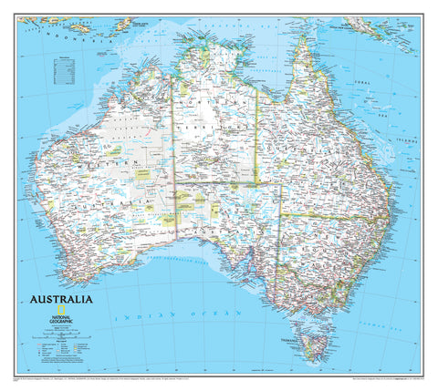
Australia Executive Antique Style National Geographic 770 x 689mm Wall Map
$59.95
or make 4 interest-free payments of
$14.99 AUD
fortnightly with
![]() More info
More info
A masterclass in cartography—timeless design meets exceptional geographic detail.
Step into the vast, vibrant landscapes of the Australian continent with this exquisitely detailed wall map from National Geographic’s esteemed Executive Series. Fusing meticulous accuracy with timeless beauty, this map is more than a visual reference—it's a centrepiece of geography, history, and art.
Whether you’re decorating a study, planning a dream trip, educating young minds, or curating a sophisticated workspace, the Executive Wall Map of Australia adds depth, character, and an unmistakable touch of refinement.
🌄 Antique Elegance with Modern Precision
Rendered in National Geographic’s signature antique colour palette, this map evokes the golden age of exploration while delivering up-to-date, research-backed geographic content. Shaded relief and subtle terrain colouring provide a vivid sense of elevation and topography, allowing mountain ranges, basins, and coastlines to stand out in elegant detail.
Perfectly blending form and function, the map is:
-
Visually soothing in earth-toned browns, golds, and greys
-
Fully modern in its geopolitical accuracy
-
Designed to enhance both educational and aesthetic settings
🌏 Rich Geographic Content
This is not just a decorative map—it’s a remarkably comprehensive geographical tool. Each map is carefully compiled using National Geographic’s rigorous research standards, and includes:
✅ Thousands of Place Names
From major capitals to tiny inland townships, with clear typographic distinction between population tiers.
✅ State and Territory Boundaries
Crisply defined with subtle border shading to honour jurisdictional divisions without visual clutter.
✅ National Parks and Protected Areas
Extensive coverage of conservation zones, including Kakadu, Uluru–Kata Tjuta, and the Daintree Rainforest.
✅ Aboriginal Lands
Highlighted to acknowledge the cultural and ancestral significance of Australia’s First Nations peoples.
✅ Transport Infrastructure
Major road networks, railways, airports, ferry routes, and ports—ideal for route planning or logistics reference.
✅ Reef and Maritime Features
Australia’s celebrated coastal and marine ecosystems are beautifully mapped, including:
-
The Great Barrier Reef
-
The Coral Sea Islands
-
The Ningaloo Reef
-
Bass Strait and Torres Strait shipping lanes
✅ Surrounding Territories
Tasmania, the Coral Sea Islands, Lord Howe Island, and Macquarie Island are all included, expanding the map’s utility beyond the mainland.
🖨️ Premium Print & Display Options
Choose the format that best suits your environment and usage:
📄 Paper Map
Printed on 160 gsm archival-quality paper, this version is:
-
Perfect for framing under glass
-
Crisp and richly printed
-
Lightweight and flexible for easy display or storage
💧 Laminated Map
Encapsulated in twin layers of 80-micron gloss laminate, this version is:
-
Water-resistant and wipeable
-
Exceptionally durable for schools, travel agencies, and offices
-
Resistant to creasing and tearing
-
Suitable for use with dry-erase markers (non-permanent)
🖼️ Canvas Map
Printed on luxurious 395 gsm HP Professional Matte Canvas using long-life pigment-based inks, the canvas version is:
-
Fade-resistant, moisture-tolerant, and made to last decades
-
Textured for a gallery-quality look and feel
-
Ideal for high-end interiors or archival displays
🪵 Optional Timber Hang Rails:
Elevate your laminated or canvas map with custom-crafted wooden hang rollers (top and bottom), finished in clear-lacquered natural timber. The top rail includes a pre-attached hanging cord—ready to mount on a single hook or nail. No framing required.
Please note: Hang-railed canvas maps are made to order. Please allow up to 10 business days for assembly and dispatch by our specialist framer.
📐 Technical Specifications
| Specification | Detail |
|---|---|
| Map Title | Executive Wall Map of Australia |
| Publisher | National Geographic Maps |
| Scale | 1:6,413,000 |
| Map Dimensions | 770 mm (width) × 689 mm (height) |
| Coverage | Mainland Australia, Tasmania, Coral Sea Islands |
| Map Style | Executive (antique-style) |
| Relief | Shaded terrain and bathymetric contours |
| Finish Options | Paper / Laminated / Canvas |
| Optional Add-On | Timber hang rails (canvas only) |
| Inks | Pigment-based for long life (canvas only) |
| Production Origin | Proudly printed in Australia |
🎁 Ideal For
-
Educators and students learning about geography, ecology, and history
-
Interior designers seeking a large-format artwork with both presence and purpose
-
Travel lovers dreaming up or reflecting on their journeys
-
Corporate offices adding sophistication to meeting rooms or lobbies
-
Map collectors looking for an authoritative and attractive reference piece
🦘 Made in Australia
Each map is printed, finished, and assembled in Australia to the highest standards. Whether you're giving it as a gift or keeping it for yourself, this map reflects National Geographic’s legacy of accuracy, design, and educational excellence.
🛒 Ready to Order?
-
✅ In stock for immediate dispatch (paper, laminated & canvas versions)
-
🪵 Custom-built hang rail orders ship in 10 business days
-
🚚 Available for national and international delivery
Bring the beauty, scale, and story of Australia into your space with this world-class map—crafted to inspire curiosity and spark conversation for generations.
Frequently Asked Questions
What are the dimensions of the Australia Executive Antique Style National Geographic 770 x 689mm Wall?
Mapworld wall maps range from standard 700×1000mm to large-format 1000×1430mm Supermaps. The exact dimensions for this map are shown in the product title. Where multiple sizes are available, select your preferred size when adding to cart.
Is this wall map available laminated?
Many Mapworld wall maps are available in paper, laminated, or framed finishes. Check the product options when adding to cart. Laminated maps are wipe-clean and more durable.
Is this the latest edition?
Mapworld stocks the most current editions available from all publishers. Edition year is shown in the product title where applicable. Mapworld updates its catalogue as new editions are released.
Can I write on or pin this wall map?
Laminated wall maps can be written on with whiteboard markers and wiped clean. Paper maps can be pinned on a corkboard. Choose a laminated option for a writeable surface.
Does Mapworld ship the Australia Executive Antique Style National Geographic 770 x 689mm Wall across Australia?
Yes, Mapworld ships Australia-wide. Standard shipping is a flat $7 rate, with free standard shipping on orders over $75. Express options are available at checkout. Most orders placed before 2pm AEST on weekdays are dispatched same day.
Related Items


© 2026 Mapworld. Website designed by Genie Media
X