- Australia ▾
- Topographic
▾
- Australia AUSTopo 250k (2025)
- Australia 50k Geoscience maps
- Australia 100k Geoscience maps
- Australia 250k Geoscience maps
- Australia 1:1m Geoscience maps
- New Zealand 50k maps
- New Zealand 250k maps
- New South Wales 25k maps
- New South Wales 50k maps
- New South Wales 100k maps
- Queensland 10k maps
- Queensland 25k maps
- Queensland 50k maps
- Queensland 100k maps
- Western Australia 25k maps
- Western Australia 50k maps
- Western Australia 100k maps
- Compasses
- Software
- GPS Systems
- International ▾
- Wall Maps
▾
- World
- Australia & New Zealand
- Countries, Continents & Regions
- Historical
- Vintage National Geographic
- Australian Capital Territory
- New South Wales
- Northern Territory
- Queensland
- South Australia
- Tasmania
- Victoria
- Western Australia
- Celestial
- Children's
- Mining & Resources
- Wine Maps
- Healthcare
- Postcode Maps
- Electoral Maps
- Nautical ▾
- Flags
▾
- Australian Flag Sets & Banners
- Flag Bunting
- Handwavers
- Australian National Flags
- Aboriginal Flags
- Torres Strait Islander Flags
- International Flags
- Flagpoles & Accessories
- Australian Capital Territory Flags
- New South Wales Flags
- Northern Territory Flags
- Queensland Flags
- South Australia Flags
- Tasmania Flags
- Victoria Flags
- Western Australia Flags
- Gifts ▾
- Globes ▾
Dear valued customer. Please note that our checkout is not supported by old browsers. Please use a recent browser to access all checkout capabilities


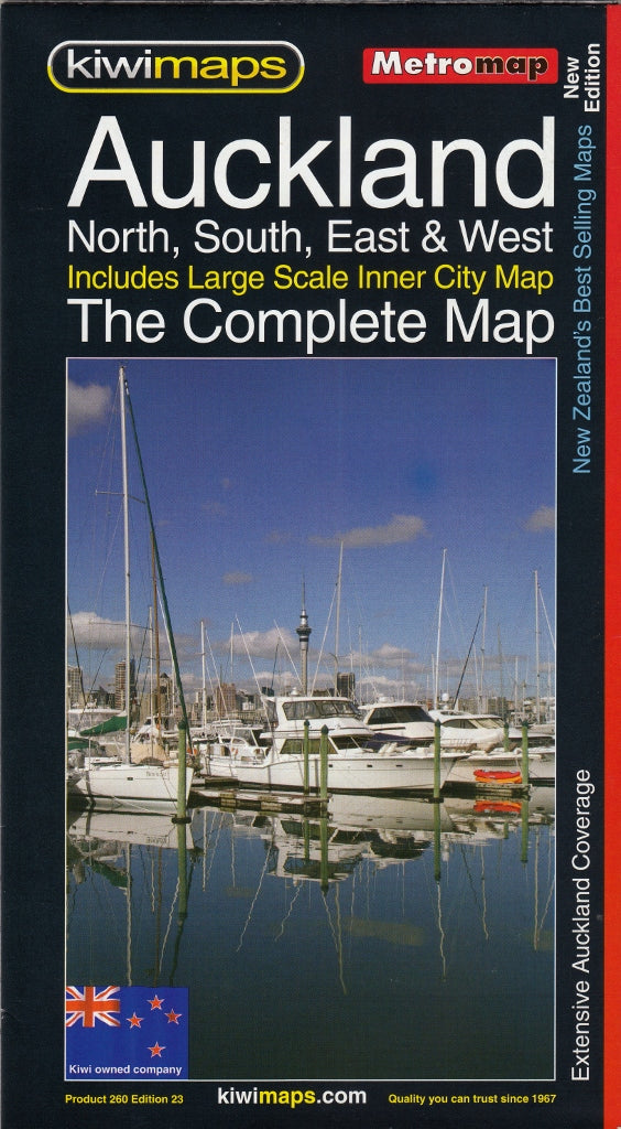
Auckland Complete New Zealand Kiwimaps Folded Map
$12.95
Afterpay is only available for orders between $50.00 and $1000.00 More info
By Kiwimaps – New Zealand’s Most Trusted Cartographers
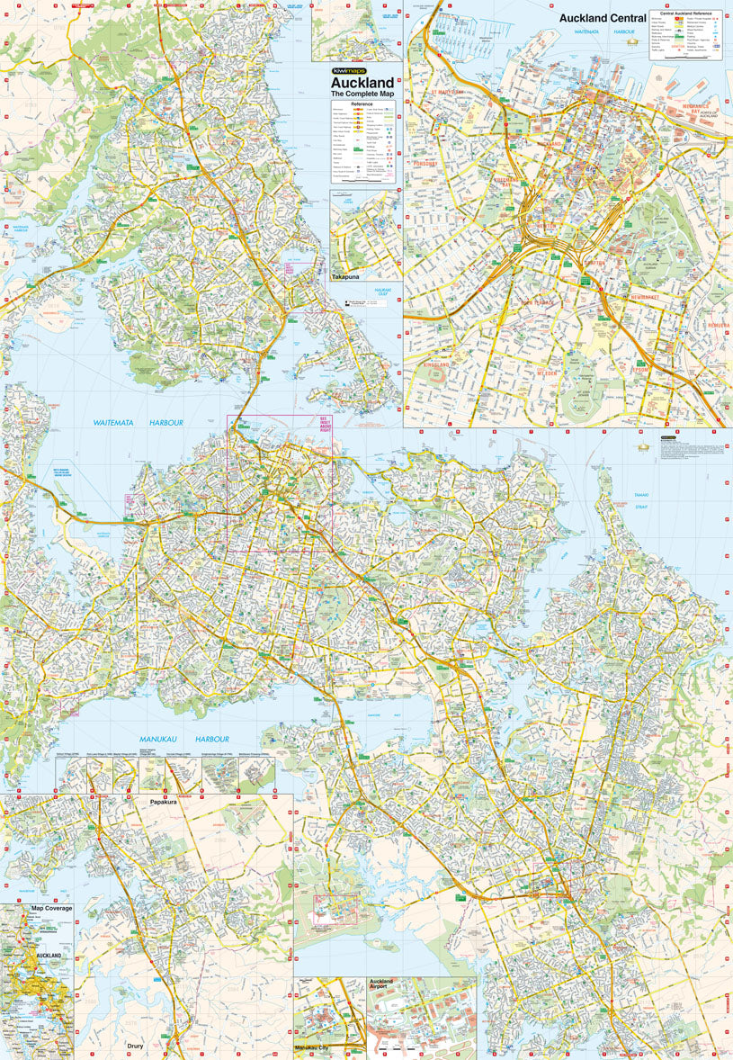
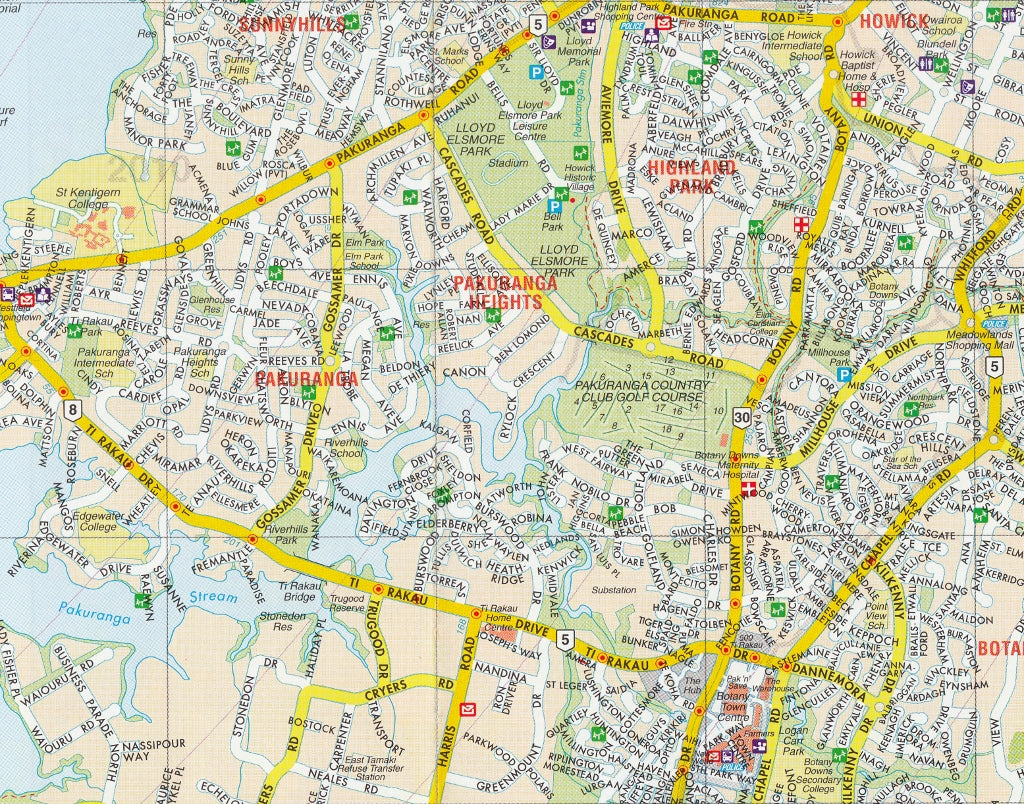
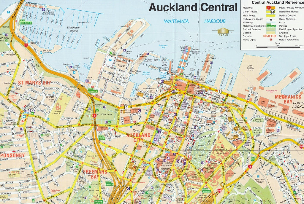
Covering the entirety of Auckland, this highly detailed and easy-to-navigate folded street map is the go-to reference for residents, travellers, and professionals alike. Published by Kiwimaps, New Zealand’s premier mapmaker, this map features an extensive street plan of the Auckland metropolitan region, supplemented with enlarged insets of key urban centres and infrastructure hubs.
Whether you're heading to the CBD, catching a flight from Auckland Airport, or exploring the North Shore or southern suburbs, this map provides everything you need to move confidently through the region.
📌 Key Features
| Attribute | Details |
|---|---|
| Coverage Area | Greater Auckland – from the outer suburbs to the heart of the city |
| Main Map Scale | 1:40,000 |
| City Centre Inset | 1:12,500 |
| Map Format | Folded, double-sided paper map |
| Publisher | Kiwimaps, New Zealand |
🔍 Map Details
-
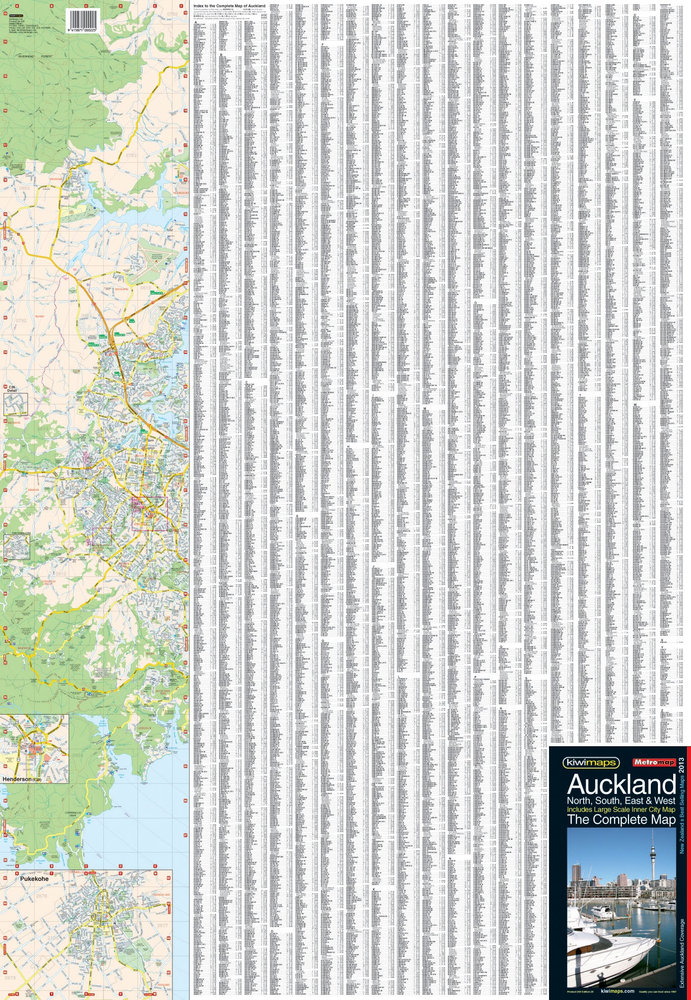
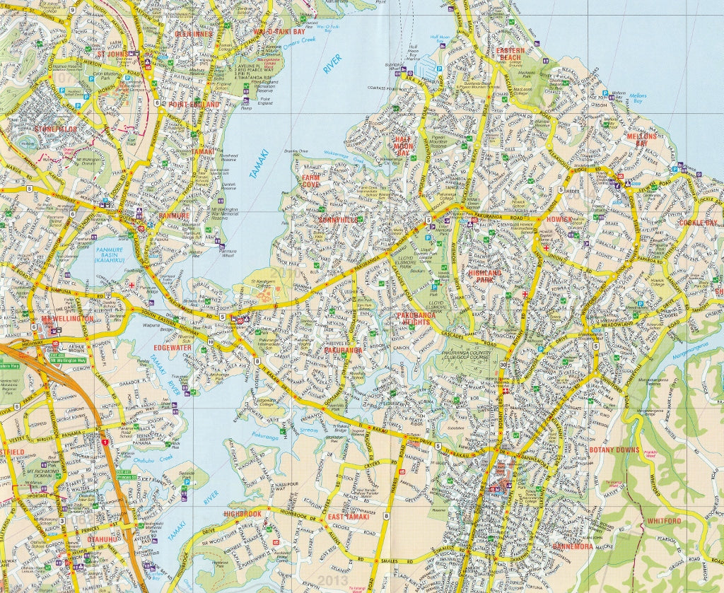
Full Metropolitan Coverage: All suburbs of Auckland are included, from Albany and Henderson to Manukau, Takapuna, and Pukekohe.
-
City Centre Enlargement: A highly detailed plan of central Auckland (1:12,500) shows one-way streets, car parks, public buildings, ferry terminals, train stations, and more.
-
Airport Detail: A specific enlargement of Auckland International Airport ensures easy navigation for travellers and airport staff.
-
Additional Insets: Enlargements for:
-
Takapuna
-
Manukau
-
Henderson
-
Pukekohe
-
Private residential villages and newer developments
-
-
Street Index: A comprehensive alphanumeric index makes finding streets fast and efficient.
-
Tourist Route Markings: Major exits and connections to New Zealand’s designated scenic and heritage drives are clearly marked.
-
Suburb Labelling: Clearly labelled districts and boundaries for orientation within the greater city.
-
Postcodes & Postal Districts: Postal boundaries are overlaid and colour coded for postal planning and deliveries.
-
Circular Distance Grid: A subtle but innovative circular radius grid is centred on the intersection of Queen and Victoria Streets, giving quick distance estimates to and from Auckland’s heart.
🎯 Ideal For
-
Delivery drivers and logistics professionals
-
Tourists and road trippers exploring Auckland
-
Property buyers, real estate professionals, and urban planners
-
Everyday Aucklanders who want a complete reference of their city
-
Anyone navigating New Zealand’s largest and most diverse metropolis
Whether you're heading out for a day trip to the Waitākere Ranges or planning your commute across the Harbour Bridge, the Auckland Complete Map by Kiwimaps ensures you have the most up-to-date and detailed street-level guide available.
A practical essential for anyone spending time in Tāmaki Makaurau.
Frequently Asked Questions
What area does the Auckland Complete New Zealand Kiwimaps Folded Map cover?
The Auckland Complete New Zealand Kiwimaps Folded Map provides road coverage of the region named in the product title. The map covers major cities, highways, towns, and regional roads, with inset city maps for key urban centres where applicable.
Is the Auckland Complete New Zealand Kiwimaps Folded Map up to date?
Yes, this is the current edition. Mapworld stocks the most current editions from all major publishers, updated to reflect new roads and infrastructure.
What size is this map when unfolded?
Folded maps from Mapworld's range are compact and portable. Most standard folded road or travel maps open to between A1 (594 × 841mm) and A0 (841 × 1189mm) when fully unfolded, and fold down to approximately A4 or smaller for easy storage in a glove box, bag, or backpack.
Is the Auckland Complete New Zealand Kiwimaps Folded Map in stock at Mapworld?
Mapworld maintains extensive stock across its map range and aims for fast dispatch. Orders placed before 2pm AEST on business days are typically dispatched the same day, with standard and express Australia-wide delivery options available.
Does Mapworld ship the Auckland Complete New Zealand Kiwimaps Folded Map across Australia?
Yes, Mapworld ships Australia-wide. Standard shipping is a flat $7 rate, with free standard shipping on orders over $75. Express options are available at checkout. Most orders placed before 2pm AEST on weekdays are dispatched same day.
Related Items
© 2026 Mapworld. Website designed by Genie Media
X