- Australia ▾
- Topographic
▾
- Australia AUSTopo 250k (2025)
- Australia 50k Geoscience maps
- Australia 100k Geoscience maps
- Australia 250k Geoscience maps
- Australia 1:1m Geoscience maps
- New Zealand 50k maps
- New Zealand 250k maps
- New South Wales 25k maps
- New South Wales 50k maps
- New South Wales 100k maps
- Queensland 10k maps
- Queensland 25k maps
- Queensland 50k maps
- Queensland 100k maps
- Western Australia 25k maps
- Western Australia 50k maps
- Western Australia 100k maps
- Compasses
- Software
- GPS Systems
- International ▾
- Wall Maps
▾
- World
- Australia & New Zealand
- Countries, Continents & Regions
- Historical
- Vintage National Geographic
- Australian Capital Territory
- New South Wales
- Northern Territory
- Queensland
- South Australia
- Tasmania
- Victoria
- Western Australia
- Celestial
- Children's
- Mining & Resources
- Wine Maps
- Healthcare
- Postcode Maps
- Electoral Maps
- Nautical ▾
- Flags
▾
- Australian Flag Sets & Banners
- Flag Bunting
- Handwavers
- Australian National Flags
- Aboriginal Flags
- Torres Strait Islander Flags
- International Flags
- Flagpoles & Accessories
- Australian Capital Territory Flags
- New South Wales Flags
- Northern Territory Flags
- Queensland Flags
- South Australia Flags
- Tasmania Flags
- Victoria Flags
- Western Australia Flags
- Gifts ▾
- Globes ▾
Dear valued customer. Please note that our checkout is not supported by old browsers. Please use a recent browser to access all checkout capabilities


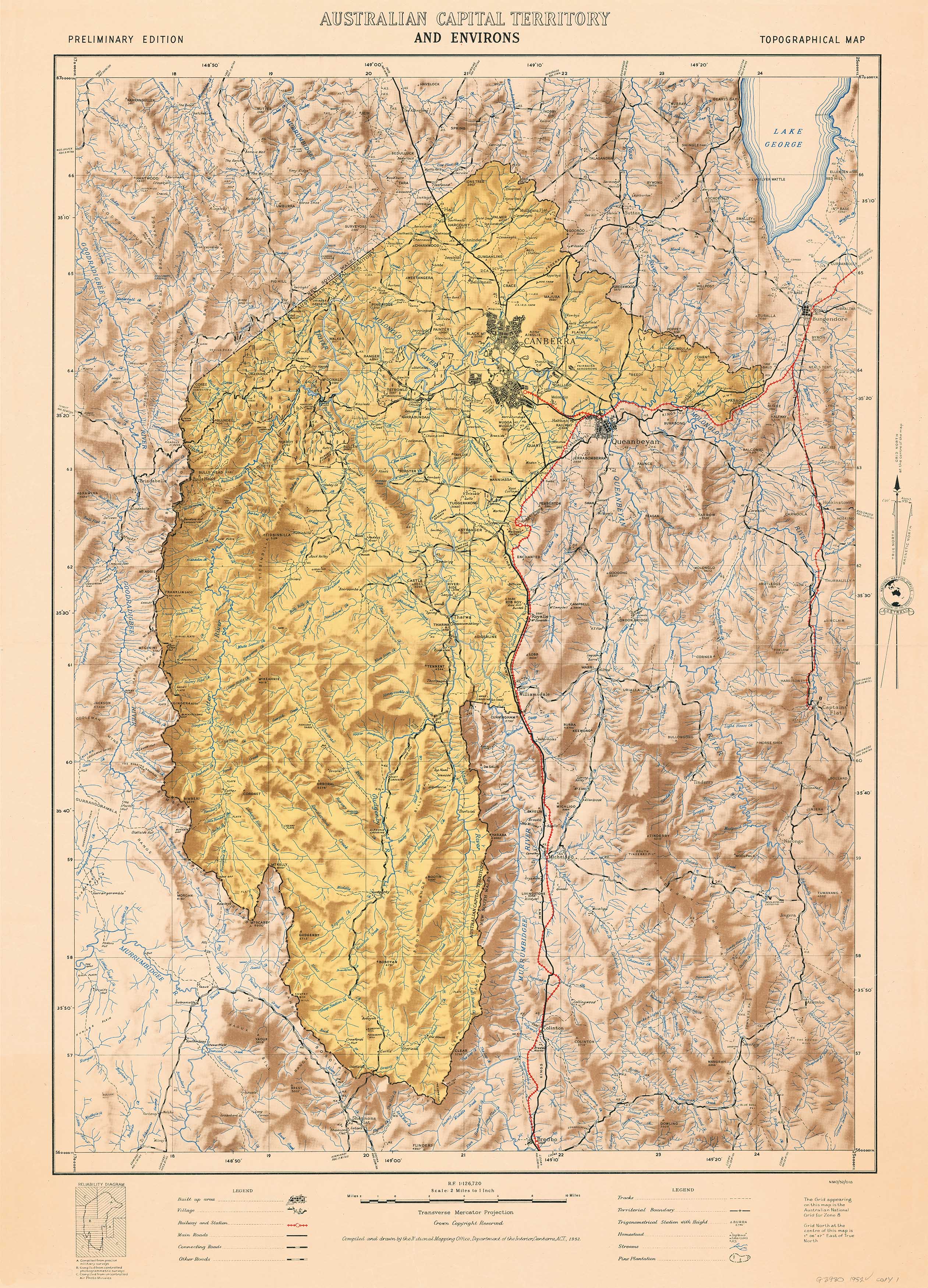
ACT & Environs Wall Map 1952
$59.95
or make 4 interest-free payments of
$14.99 AUD
fortnightly with
![]() More info
More info
Compiled by the National Mapping Office, Department of the Interior, Canberra
Size: 680 mm (W) x 950 mm (H)
🗺️ A historically rich topographic map of the Australian Capital Territory and its surrounding regions, captured with exquisite hill shading and mid-century precision.
📜 A Landmark Map of the Capital in 1952
This beautifully detailed topographic map of the ACT and Environs, first published in 1952, was compiled and drawn by the National Mapping Office—a division of the Department of the Interior based in Canberra. With its expertly rendered hill shading, this map provides a striking visual of the region's terrain as it was in the early days of Canberra’s development as Australia's political heart.
Capturing the natural contours, built environment, and landscape patterns of the Australian Capital Territory and surrounding areas, this map is a powerful historical document—ideal for historians, educators, and anyone passionate about Australian cartography or the evolution of our capital city.
🌄 Map Features
-
🏞️ Topographic detail with fine hill shading for accurate terrain representation
-
🏛️ Shows Canberra in its early post-war development phase
-
📍 Labels key roads, rivers, ridgelines, and settlements
-
🧭 Features surrounding regions including Queanbeyan, Yass, and parts of NSW
-
🖋️ A vintage aesthetic created by the National Mapping Office in 1952
-
🎓 Ideal for history classrooms, cartographic collectors, and capital region enthusiasts
🖨️ Available in Three Archival-Quality Finishes
Each format is designed for longevity and professional presentation:
📄 160gsm Matte Art Paper
-
Ideal for custom framing
-
Smooth, glare-free finish
-
Classic and lightweight
💧 Laminated – 80 Micron Gloss Encapsulation
-
Encapsulated front and back with durable 80-micron gloss laminate
-
Tear-resistant, moisture-resistant, and wipeable
-
Perfect for offices, classrooms, and frequent handling
🖼️ 395gsm HP Professional Matte Canvas
-
Printed on heavyweight 395gsm cotton-blend canvas
-
Pigment-based archival inks for outstanding fade resistance
-
Textured matte finish for a sophisticated display
-
Available with optional timber hang rails for a classic, gallery-style presentation
⏳ Please allow 10 working days for hang rail assembly by our professional framer.
🪵 Optional Timber Hang Rails – Laminated & Canvas
Upgrade your map to a ready-to-hang piece:
-
🪵 Lacquered natural timber battens attached top and bottom
-
🧵 Includes a hanging cord on the top rail—just hook it on your wall
-
🖐️ Assembled by hand for a perfectly balanced, polished finish
📐 Specifications
| Feature | Description |
|---|---|
| Map Title | ACT & Environs Topographical Map |
| Published | 1952 |
| Produced By | National Mapping Office, Department of the Interior |
| Map Type | Topographical with hill shading |
| Region Covered | Australian Capital Territory and surrounds |
| Size | 680 mm (W) x 950 mm (H) |
| Material Options | 160gsm Paper, Laminated, or Canvas |
| Canvas Material | 395gsm HP Professional Matte Canvas |
| Ink Type (Canvas) | Pigment-based archival inks |
| Optional Finish | Timber hang rails |
| Printed & Assembled | Proudly in Australia |
🧳 Ideal For:
-
🧭 Map collectors and history enthusiasts
-
🏫 Educators and students studying Canberra’s urban development
-
🏛️ Government offices or institutions based in the ACT
-
🖼️ Interior design with an Australian historical or vintage theme
-
🎁 Thoughtful gifts for Canberrans, surveyors, or geography lovers
🇦🇺 Proudly Made in Australia
This map is professionally printed and assembled in Australia using archival-quality materials. From its subtle hill shading to its cartographic heritage, it’s a stunning reminder of how the ACT took shape in the mid-20th century.
🛒 Order Yours Today
Use the dropdown above to select:
-
Paper – Ready to frame
-
Laminated – Long-lasting and practical
-
Canvas – A premium finish with optional timber hang rails
A timeless portrait of Australia’s capital in its formative years—historic, beautiful, and ready to display.
Frequently Asked Questions
What are the dimensions of the ACT & Environs Wall Map 1952?
Mapworld wall maps range from standard 700×1000mm to large-format 1000×1430mm Supermaps. The exact dimensions for this map are shown in the product title. Where multiple sizes are available, select your preferred size when adding to cart.
Is this wall map available laminated?
Many Mapworld wall maps are available in paper, laminated, or framed finishes. Check the product options when adding to cart. Laminated maps are wipe-clean and more durable.
Is this the latest edition?
Mapworld stocks the most current editions available from all publishers. Edition year is shown in the product title where applicable. Mapworld updates its catalogue as new editions are released.
Can I write on or pin this wall map?
Laminated wall maps can be written on with whiteboard markers and wiped clean. Paper maps can be pinned on a corkboard. Choose a laminated option for a writeable surface.
Does Mapworld ship the ACT & Environs Wall Map 1952 across Australia?
Yes, Mapworld ships Australia-wide. Standard shipping is a flat $7 rate, with free standard shipping on orders over $75. Express options are available at checkout. Most orders placed before 2pm AEST on weekdays are dispatched same day.
Related Items


© 2026 Mapworld. Website designed by Genie Media
X