- Australia ▾
- Topographic
▾
- Australia AUSTopo 250k (2025)
- Australia 50k Geoscience maps
- Australia 100k Geoscience maps
- Australia 250k Geoscience maps
- Australia 1:1m Geoscience maps
- New Zealand 50k maps
- New Zealand 250k maps
- New South Wales 25k maps
- New South Wales 50k maps
- New South Wales 100k maps
- Queensland 10k maps
- Queensland 25k maps
- Queensland 50k maps
- Queensland 100k maps
- Western Australia 25k maps
- Western Australia 50k maps
- Western Australia 100k maps
- Compasses
- Software
- GPS Systems
- International ▾
- Wall Maps
▾
- World
- Australia & New Zealand
- Countries, Continents & Regions
- Historical
- Vintage National Geographic
- Australian Capital Territory
- New South Wales
- Northern Territory
- Queensland
- South Australia
- Tasmania
- Victoria
- Western Australia
- Celestial
- Children's
- Mining & Resources
- Wine Maps
- Healthcare
- Postcode Maps
- Electoral Maps
- Nautical ▾
- Flags
▾
- Australian Flag Sets & Banners
- Flag Bunting
- Handwavers
- Australian National Flags
- Aboriginal Flags
- Torres Strait Islander Flags
- International Flags
- Flagpoles & Accessories
- Australian Capital Territory Flags
- New South Wales Flags
- Northern Territory Flags
- Queensland Flags
- South Australia Flags
- Tasmania Flags
- Victoria Flags
- Western Australia Flags
- Gifts ▾
- Globes ▾
Dear valued customer. Please note that our checkout is not supported by old browsers. Please use a recent browser to access all checkout capabilities


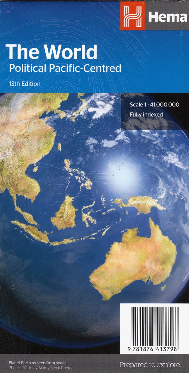
World Political Pacific Centred Hema Folded Map
$13.95
Afterpay is only available for orders between $50.00 and $1000.00 More info
Clear Political Boundaries | Colourful Cartography | Portable, Practical & Pacific-Focused
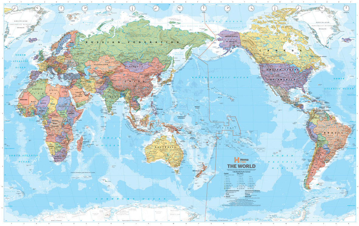
This Pacific-Centred Political World Map is a beautifully designed, highly practical reference tool that folds neatly for portability and convenience. Featuring vibrant political boundaries, easy-to-read labelling, and a unique orientation focused on the Pacific region, this map presents the world from a fresh and globally inclusive perspective—perfect for Australian and Asia-Pacific users.
With a scale of 1:41,000,000, it provides a balanced view of the world's continents and oceans while helping the viewer better understand international relationships, time zones, and global positioning. The map folds down for compact storage, making it ideal for:
-
📚 Teachers and students
-
✈️ Travellers
-
🧭 Tour guides and planners
-
🏠 Anyone with limited wall space
🗺️ Map Features
-
Pacific-Centred Orientation
Unlike traditional Atlantic-centred world maps, this version places the Pacific Ocean at the centre, showcasing Australasia, Southeast Asia, and the Americas with equal prominence. This layout is especially relevant for users in Australia, New Zealand, Japan, the Pacific Islands, and the west coast of the Americas. -
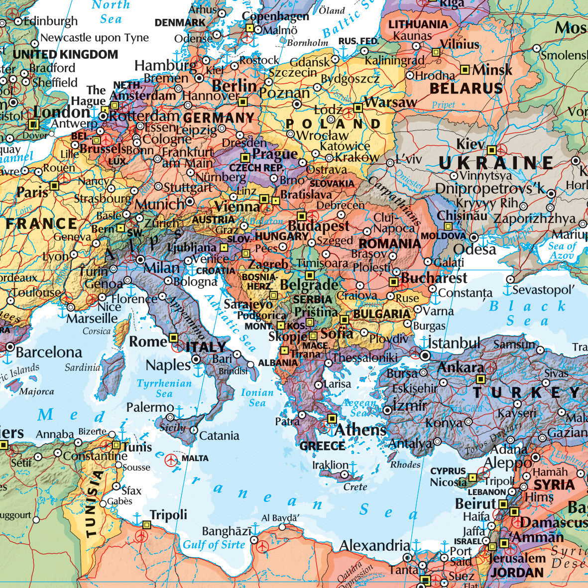
Clear Political Boundaries
Each country is coloured distinctly, with borders clearly defined. Major cities and capitals are clearly marked, making this map an excellent educational tool or travel reference. -
Relief Shading & Ocean Features
Subtle terrain shading adds visual depth to mountain ranges and highlands. Major ocean currents and undersea features are also labelled, enhancing geographic understanding. -
International Date Line
Shown accurately and cleanly, this feature helps clarify time zone differences and global positioning—an essential tool for educators, logistics professionals, and travellers.
📐 Specifications
| Attribute | Detail |
|---|---|
| Scale | 1:41,000,000 |
| Unfolded Size | 1010 mm (W) × 715 mm (H) |
| Format | Folded paper map |
| Paper Stock | High-quality matte finish |
| Map Type | Political (with physical features) |
| Publisher | Hema or similar trusted supplier |
📦 Why Choose the Folded Version?
-
🧳 Portable – Folds down to a compact size for backpacks, glove compartments, or travel bags
-
🖼️ Versatile – Use on a tabletop, hang temporarily, or frame as a rotating educational tool
-
🎓 Classroom-Friendly – Easy to distribute, annotate, or pass around in a learning environment
-
🏕️ Travel Ready – Lightweight and ideal for on-the-road referencing during international trips
-
🧑🏫 Ideal for Presentations – Open out on a desk or whiteboard for workshops, lectures, or planning
🧭 Who Is This Map For?
-
Educators – Teach students about countries, borders, and global geography from a southern hemisphere perspective
-
Travel Enthusiasts – Use it to track travels or plan journeys across continents
-
Offices & Agencies – Compact reference for international business, freight logistics, or geopolitical discussions
-
Students – A useful revision tool for geography exams, easily kept in a folder or backpack
-
Gift Buyers – Makes a thoughtful and affordable present for curious minds or travellers
📚 Did You Know?
The Pacific-centred perspective challenges the typical Eurocentric worldview by shifting focus to the Asia-Pacific basin, the most dynamic and fastest-growing region in the 21st century. From trade routes to tectonic plates, this map offers insights into why the Pacific is increasingly central to global understanding.
🛒 Buying Options
-
📄 This Listing: Folded edition (high-quality paper, matte finish)
-
🔁 Also Available:
-
Flat laminated version – ideal for framing or permanent wall display
-
Canvas-mounted option – museum-quality print with optional hang rails
-
✨ Enhance Your World View
This Pacific-Centred Political World Map – Folded Edition is more than just a map. It's a conversation piece, an educational aid, and a visual bridge between continents. Compact, colourful, and current—it's ready to travel with you or become your most trusted guide to the world.
Frequently Asked Questions
What area does the World Political Pacific Centred Hema Folded Map cover?
The World Political Pacific Centred Hema Folded Map provides road coverage of the region named in the product title. The map covers major cities, highways, towns, and regional roads, with inset city maps for key urban centres where applicable.
Is the World Political Pacific Centred Hema Folded Map up to date?
Yes, this is the current edition. Mapworld stocks the most current editions from all major publishers, updated to reflect new roads and infrastructure.
What size is this map when unfolded?
Folded maps from Mapworld's range are compact and portable. Most standard folded road or travel maps open to between A1 (594 × 841mm) and A0 (841 × 1189mm) when fully unfolded, and fold down to approximately A4 or smaller for easy storage in a glove box, bag, or backpack.
Is the World Political Pacific Centred Hema Folded Map in stock at Mapworld?
Mapworld maintains extensive stock across its map range and aims for fast dispatch. Orders placed before 2pm AEST on business days are typically dispatched the same day, with standard and express Australia-wide delivery options available.
Does Mapworld ship the World Political Pacific Centred Hema Folded Map across Australia?
Yes, Mapworld ships Australia-wide. Standard shipping is a flat $7 rate, with free standard shipping on orders over $75. Express options are available at checkout. Most orders placed before 2pm AEST on weekdays are dispatched same day.
Related Items


© 2026 Mapworld. Website designed by Genie Media
X