Size: 1540 mm (W) × 1020 mm (H) | Scale: 1:22,445,000
A Masterclass in Cartography – Elegant, Accurate, and Incredibly Detailed
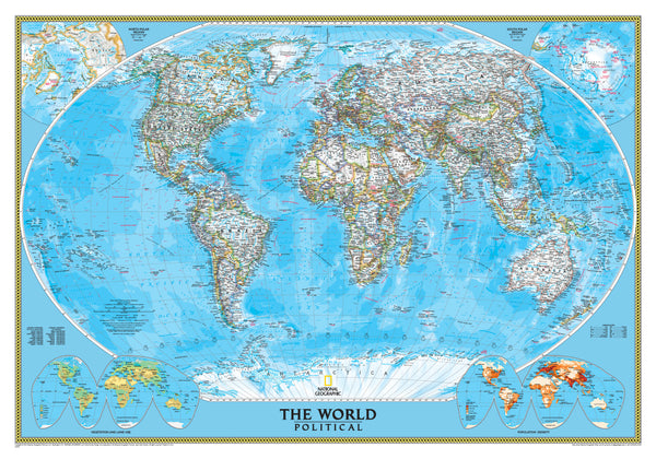
Bring the world into focus with this Africa-Centred Political Wall Map by National Geographic—a stunning large-format reference piece that combines elegant design with exceptional geographic clarity. Whether you’re outfitting a classroom, home study, or office, this map offers both beauty and substance.
✅ Key Features
🗺️ True Political Clarity
-
Features clearly defined country borders using bold die lines
-
Nations shown in white for easy-to-read place names and capital cities
-
Includes disputed boundaries, regional names, and major cities
⛰️ Topographical & Oceanic Detail
-
Mountain ranges illustrated using shaded relief for depth and realism
-
Ocean currents and bathymetric (depth) contours make the seas come alive
-
Far more oceanographic detail than standard political maps
🌐 Africa-Centred Winkel Tripel Projection
-
Uses the Winkel tripel projection to minimise distortion—especially near the poles
-
Africa-centred for a more balanced and global perspective
-
Ideal for educators, researchers, and anyone looking to see the world without bias
📊 Inset Maps & Data Layers
-
Includes thematic inset maps showing:
-
Population Density
-
Vegetation Zones
-
Land Use Patterns
-
Premium Printing & Materials
Choose from three exquisite finishes:
| Finish | Details |
|---|---|
| Paper (160 gsm) | Heavyweight matte paper, perfect for framing under glass |
| Laminated | Encapsulated in two sheets of 80-micron gloss laminate – durable & wipe-clean |
| Canvas (395 gsm) | HP Professional Matte Canvas with pigment inks – fade-resistant, archival-quality |
🖼️ Framing & Display Options
✔️ Optional Wooden Hanging Battens
Add natural timber hang rails with cord for a ready-to-display piece. Just one hook needed.
Please allow up to 10 working days for framed versions.
📏 Specifications
| Feature | Detail |
|---|---|
| Map Title | World Political – Africa Centred |
| Publisher | National Geographic Society |
| Scale | 1:22,445,000 |
| Size | 1540 mm (W) × 1020 mm (H) |
| Projection | Winkel Tripel |
| Published | 2018 Edition |
| Made in | Australia |
Why This Map?
✔️ Designed by one of the world’s most trusted cartographic institutions
✔️ Strikes the perfect balance between form and function
✔️ A standout addition to any wall—whether you're planning global travels or teaching geography
🛒 Add this exceptional World Political Map to your cart today and enjoy a lifelong journey of discovery—right from your wall.


