- Australia ▾
- Topographic
▾
- Australia AUSTopo 250k (2024)
- Australia 50k Geoscience maps
- Australia 100k Geoscience maps
- Australia 250k Geoscience maps
- Australia 1.1m Geoscience maps
- New Zealand 50k maps
- New Zealand 250k maps
- New South Wales 25k maps
- New South Wales 50k maps
- New South Wales 100k maps
- Queensland 10k maps
- Queensland 25k maps
- Queensland 50k maps
- Queensland 100k maps
- Compasses
- Software
- GPS Systems
- Orienteering
- International ▾
- Wall Maps
▾
- World
- Australia & New Zealand
- Countries, Continents & Regions
- Historical
- Vintage National Geographic
- Australian Capital Territory
- New South Wales
- Northern Territory
- Queensland
- South Australia
- Tasmania
- Victoria
- Western Australia
- Celestial
- Children's
- Mining & Resources
- Wine Maps
- Healthcare
- Postcode Maps
- Electoral Maps
- Nautical ▾
- Flags
▾
- Australian Flag Sets & Banners
- Flag Bunting
- Handwavers
- Australian National Flags
- Aboriginal Flags
- Torres Strait Islander Flags
- International Flags
- Flagpoles & Accessories
- Australian Capital Territory Flags
- New South Wales Flags
- Northern Territory Flags
- Queensland Flags
- South Australia Flags
- Tasmania Flags
- Victoria Flags
- Western Australia Flags
- Gifts ▾
- Globes ▾
Dear valued customer. Please note that our checkout is not supported by old browsers. Please use a recent browser to access all checkout capabilities
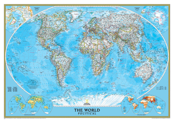
World Political National Geographic 1540 x 1020mm (Africa Centred) Large Laminated Wall Map with Hang Rails
$349.95
or make 4 interest-free payments of
$87.49 AUD
fortnightly with
![]() More info
More info
🌍 Africa-Centred World Political Map – Large Format Laminated with Hang Rails
By National Geographic Society
Size: 1540 mm (W) × 1020 mm (H) | Projection: Winkel Tripel | Scale: 1:36,384,000
Finish: Encapsulated Gloss Laminate | Mounting: Natural Timber Hang Rails
Made in Australia
🗺 The World, Reframed – Africa at the Heart
This large-format Africa-Centred Political World Map from the National Geographic Society offers a strikingly different way to view our planet.
By placing Africa—not Europe or the Americas—at the centre, the map opens up new perspectives on global geography, cultural relationships, and continental connections. It’s more than just a map—it’s a conversation starter, a teaching tool, and a work of cartographic art.
With breathtaking detail, durable construction, and an elegant ready-to-hang presentation, it’s ideal for classrooms, corporate offices, and homes where a global perspective matters.
📌 Distinctive Cartographic Features
Africa-Centred Projection
-
Moves away from Eurocentric layouts, highlighting a balanced global perspective.
-
Encourages fresh discussion on political, trade, and cultural relationships.
Winkel Tripel Projection
-
National Geographic’s preferred projection for its reduced distortion of shapes and sizes.
-
Offers a more visually harmonious and geographically accurate depiction of the Earth.
Political & Physical Layering
-
Heavy coloured die lines outline each country for instant recognition.
-
Crisp white interiors keep place names clear and easy to read.
-
Shaded relief illustrates mountain ranges in exquisite detail.
-
Includes ocean depths, currents, and undersea topography—details rarely found on standard political maps.
Informative Insets
-
Miniature maps display global population density, vegetation zones, and land use patterns.
-
Adds depth and context, making this an educational powerhouse.
🔒 Built for Durability – Laminated for Life
-
Encapsulated with two layers of premium 80-micron gloss laminate.
-
Tear-resistant, moisture-proof, and UV-protected to prevent fading.
-
Wipe-clean surface—ideal for busy environments.
-
Compatible with Mark-It-Dots for travel tracking, teaching highlights, or pin-pointing research locations.
🪵 Professional Timber Hang Rails – Ready to Mount
-
Natural lacquered finish for timeless appeal.
-
Top and bottom rails keep the map flat and protected.
-
Pre-fitted hanging cord means all you need is a wall hook.
-
Eliminates the need for framing while giving a gallery-quality presentation.
Note: Please allow up to 10 working days for delivery of hang-railed maps, as each is professionally mounted by our framer for a flawless finish.
📏 Specifications
| Feature | Details |
|---|---|
| Publisher | National Geographic Society |
| Projection | Winkel Tripel |
| Map Style | Political (Africa-Centred) |
| Insets | Population Density, Vegetation, Land Use |
| Finish | Encapsulated Gloss Laminate |
| Mounting | Natural Timber Hang Rails |
| Scale | 1:36,384,000 |
| Dimensions | 1540 mm (W) × 1020 mm (H) |
| Made In | Australia |
🌟 Why You’ll Love This Map
-
✅ A New Perspective – Repositions Africa at the centre for a balanced worldview.
-
✅ National Geographic Accuracy – Backed by over 135 years of cartographic excellence.
-
✅ Extra-Large Size – A commanding presence in any room.
-
✅ Durable & Practical – Laminated for years of use and protection.
-
✅ Effortless Display – Elegant timber hang rails included.
📚 Perfect For:
✔️ Schools & universities teaching world geography
✔️ Corporate spaces with an international outlook
✔️ World travellers tracking their adventures
✔️ Homes seeking a statement wall piece
✔️ Gifts for academics, diplomats, or map enthusiasts
Put Africa where it belongs—at the heart of the world
Whether you’re educating, planning, or simply admiring the beauty of our planet, this large-format Africa-Centred Political Map offers both aesthetic appeal and practical functionality.
Order now to enjoy a globally respected National Geographic map in a premium, ready-to-hang format that will last for years to come.


