- Australia ▾
- Topographic
▾
- Australia AUSTopo 250k (2025)
- Australia 50k Geoscience maps
- Australia 100k Geoscience maps
- Australia 250k Geoscience maps
- Australia 1:1m Geoscience maps
- New Zealand 50k maps
- New Zealand 250k maps
- New South Wales 25k maps
- New South Wales 50k maps
- New South Wales 100k maps
- Queensland 10k maps
- Queensland 25k maps
- Queensland 50k maps
- Queensland 100k maps
- Compasses
- Software
- GPS Systems
- Orienteering
- International ▾
- Wall Maps
▾
- World
- Australia & New Zealand
- Countries, Continents & Regions
- Historical
- Vintage National Geographic
- Australian Capital Territory
- New South Wales
- Northern Territory
- Queensland
- South Australia
- Tasmania
- Victoria
- Western Australia
- Celestial
- Children's
- Mining & Resources
- Wine Maps
- Healthcare
- Postcode Maps
- Electoral Maps
- Nautical ▾
- Flags
▾
- Australian Flag Sets & Banners
- Flag Bunting
- Handwavers
- Australian National Flags
- Aboriginal Flags
- Torres Strait Islander Flags
- International Flags
- Flagpoles & Accessories
- Australian Capital Territory Flags
- New South Wales Flags
- Northern Territory Flags
- Queensland Flags
- South Australia Flags
- Tasmania Flags
- Victoria Flags
- Western Australia Flags
- Gifts ▾
- Globes ▾
Dear valued customer. Please note that our checkout is not supported by old browsers. Please use a recent browser to access all checkout capabilities


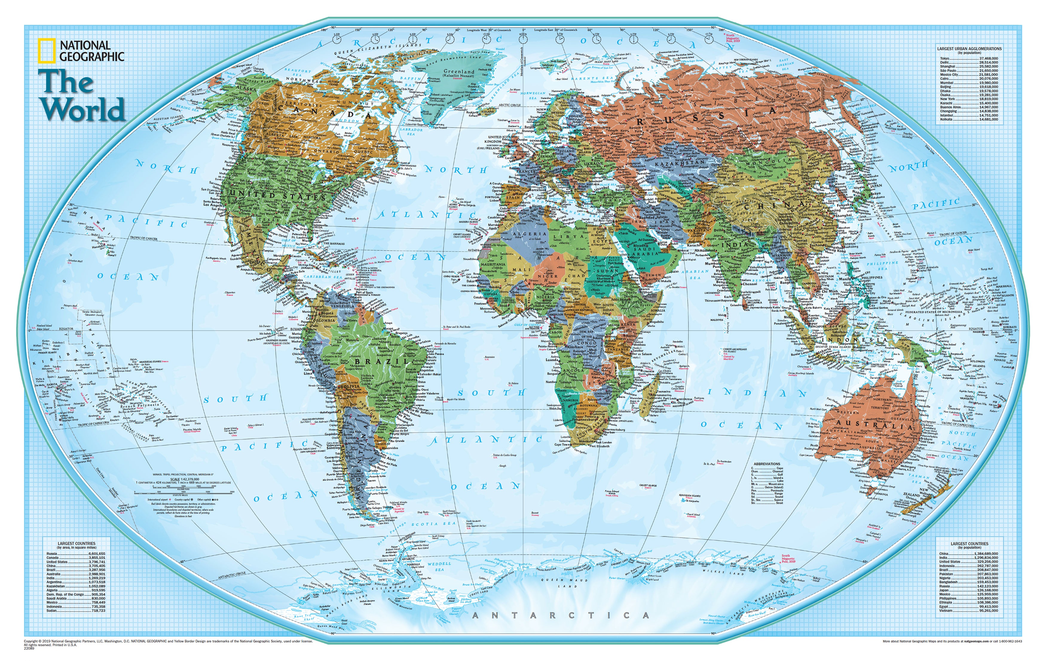
World Explorer National Geographic 813 x 511mm Wall Map
$59.95
or make 4 interest-free payments of
$14.99 AUD
fortnightly with
![]() More info
More info
🌍 World Explorer Map – National Geographic
Dimensions: 813 mm (W) × 511 mm (H) | Projection: Winkel Tripel | Scale: 1:42,334,000
Finish Options: Heavyweight Paper, Laminated, or Canvas | Optional: Timber Hang Rails
Made in Australia
🗺 The World at Your Fingertips – National Geographic’s Explorer Style
The World Explorer Map by National Geographic is the cartographic benchmark against which all others are measured. Every element—down to the finest detail—has been meticulously researched using multiple authoritative sources, with National Geographic’s independent, apolitical approach ensuring both accuracy and integrity.
This isn’t just a map—it’s a vivid, compelling portrait of our planet. The Explorer Style employs a vibrant colour palette where each nation is uniquely shaded for quick identification, set against a pale blue background grid that echoes traditional cartographic craftsmanship. Combine this with stunning shaded relief and crystal-clear labelling, and you have a map that’s equally suited to education, décor, and inspiration.
Whether you hang it in a classroom to teach geography, in a home office to plan adventures, or in your living space as an elegant conversation starter, this map delivers both beauty and authority.
📌 Distinctive Features That Set It Apart
Winkel Tripel Projection – Accuracy Meets Aesthetics
-
National Geographic’s preferred projection for a more balanced view of the Earth.
-
Corrects distortions common in older maps—Greenland appears proportionate, not bigger than South America.
-
Ideal for a global perspective that feels both natural and accurate.
Explorer Style Colour Scheme
-
Bright, rich hues clearly distinguish each country without overwhelming the eye.
-
Shaded relief gives depth to continents and mountain ranges, making physical geography come alive.
-
Light blue background grid reinforces the map’s precision and timeless appeal.
Detailed & Legible Labelling
-
Thousands of place names, capitals, cities, rivers, and ocean features are carefully positioned for clarity.
-
Maintains legibility in high-density areas like Europe, Asia, and the Middle East.
Oceanic & Physical Detail
-
Ocean floor contours and features bring marine geography into focus.
-
Includes international boundaries, major rivers, mountain ranges, deserts, and islands.
Educational Insets
-
Largest Cities by Population – Quick reference for the world’s major urban hubs.
-
Largest Countries by Area & Population – Compare global giants at a glance.
🖼 Premium Finish Options – Designed for Every Space
📄 Heavyweight Paper (160 gsm)
-
Smooth matte surface ideal for framing under glass.
-
Crisp, museum-quality print that maintains fine detail.
-
Ships rolled in a protective mailing tube for safe delivery.
💧 Encapsulated Gloss Laminate
-
Fully sealed between two 80-micron gloss sheets for durability.
-
Waterproof, tear-resistant, and UV-protected—perfect for classrooms, offices, and high-traffic areas.
-
Wipe-clean surface works with whiteboard markers and map dots.
🎨 HP Professional Matte Canvas (395 gsm)
-
Printed using archival pigment-based inks for rich, fade-resistant colour.
-
Luxurious textured finish gives the appearance of an art piece.
-
Long-lasting and durable—ideal for display in living rooms, libraries, and executive spaces.
🪵 Optional Timber Hang Rails – Elegant, Ready-to-Hang Display
-
Crafted from smooth, natural lacquered timber.
-
Fitted top and bottom for weight and structure.
-
Includes a discreet hanging cord for simple one-hook installation.
-
No need for extra framing—display straight out of the box.
Please allow up to 10 working days for delivery of hang-railed maps, as each is carefully assembled by our professional framers.
📏 Specifications
| Feature | Details |
|---|---|
| Publisher | National Geographic Society |
| Projection | Winkel Tripel |
| Map Style | Political – Explorer Style |
| Inset Maps | Largest Cities, Largest Countries |
| Available Finishes | Paper, Laminated, Canvas |
| Optional Mounting | Natural Timber Hang Rails |
| Scale | 1:42,334,000 |
| Dimensions | 813 mm (W) × 511 mm (H) |
| Published | 2019 |
| Made In | Australia |
🌟 Why This Map is Exceptional
✅ Visually Striking – The vibrant Explorer palette and relief shading make it stand out in any setting.
✅ Accurate & Trusted – Built on National Geographic’s unmatched cartographic research.
✅ Versatile Finishes – From classic paper to durable laminate to premium canvas.
✅ Educational & Decorative – Works equally well as a learning aid and as elegant décor.
✅ Effortless Display – Optional hang rails make professional mounting simple and stylish.
📚 Perfect For:
✔️ Educators & Students – A trusted classroom resource.
✔️ Travel Planners – Perfect for plotting adventures and marking past journeys.
✔️ Map Collectors – A must-have for any collection.
✔️ Home & Office Décor – Adds sophistication and a global outlook to your walls.
✔️ Gift Buyers – Thoughtful, intelligent, and beautifully made.
✨ Final Word
The National Geographic World Explorer Map offers more than just geography—it delivers a global perspective wrapped in stunning design. With rich colour, precise detail, and finishes to suit any environment, it’s a map you’ll consult, admire, and share for years.
Whether you’re charting future travels, teaching the next generation, or simply admiring our world’s complexity, this map is a window to the planet at its most beautiful and accurate.
Order today and let the world unfold on your wall—crafted by experts, trusted by generations, and made to last.
Frequently Asked Questions
What are the dimensions of the World Explorer National Geographic 813 x 511mm Wall Map?
Mapworld wall maps range from standard 700×1000mm to large-format 1000×1430mm Supermaps. The exact dimensions for this map are shown in the product title. Where multiple sizes are available, select your preferred size when adding to cart.
Is this wall map available laminated?
Many Mapworld wall maps are available in paper, laminated, or framed finishes. Check the product options when adding to cart. Laminated maps are wipe-clean and more durable.
Is this the latest edition?
Mapworld stocks the most current editions available from all publishers. Edition year is shown in the product title where applicable. Mapworld updates its catalogue as new editions are released.
Can I write on or pin this wall map?
Laminated wall maps can be written on with whiteboard markers and wiped clean. Paper maps can be pinned on a corkboard. Choose a laminated option for a writeable surface.
Does Mapworld ship the World Explorer National Geographic 813 x 511mm Wall Map across Australia?
Yes, Mapworld ships Australia-wide. Standard shipping is a flat $7 rate, with free standard shipping on orders over $75. Express options are available at checkout. Most orders placed before 2pm AEST on weekdays are dispatched same day.
Related Items


© 2026 Mapworld. Website designed by Genie Media
X