- Australia ▾
- Topographic
▾
- Australia AUSTopo 250k (2025)
- Australia 50k Geoscience maps
- Australia 100k Geoscience maps
- Australia 250k Geoscience maps
- Australia 1:1m Geoscience maps
- New Zealand 50k maps
- New Zealand 250k maps
- New South Wales 25k maps
- New South Wales 50k maps
- New South Wales 100k maps
- Queensland 10k maps
- Queensland 25k maps
- Queensland 50k maps
- Queensland 100k maps
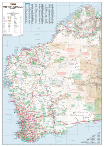
- Western Australia 25k maps
- Western Australia 50k maps
- Western Australia 100k maps
- Compasses
- Software
- GPS Systems
- International ▾
- Wall Maps
▾
- World
- Australia & New Zealand
- Countries, Continents & Regions
- Historical
- Vintage National Geographic
- Australian Capital Territory
- New South Wales
- Northern Territory
- Queensland
- South Australia
- Tasmania
- Victoria
- Western Australia
- Celestial
- Children's
- Mining & Resources
- Wine Maps
- Healthcare
- Postcode Maps
- Electoral Maps
- Nautical ▾
- Flags
▾
- Australian Flag Sets & Banners
- Flag Bunting
- Handwavers
- Australian National Flags
- Aboriginal Flags
- Torres Strait Islander Flags
- International Flags
- Flagpoles & Accessories
- Australian Capital Territory Flags
- New South Wales Flags
- Northern Territory Flags
- Queensland Flags
- South Australia Flags
- Tasmania Flags
- Victoria Flags
- Western Australia Flags
- Gifts ▾
- Globes ▾
Dear valued customer. Please note that our checkout is not supported by old browsers. Please use a recent browser to access all checkout capabilities


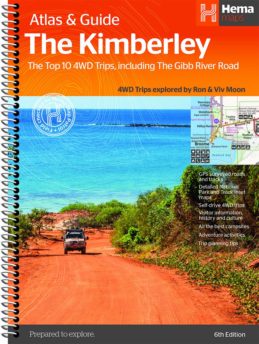

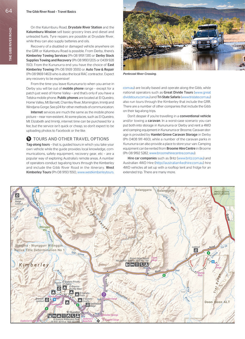
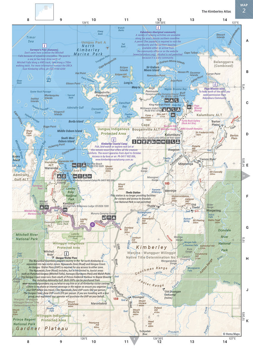
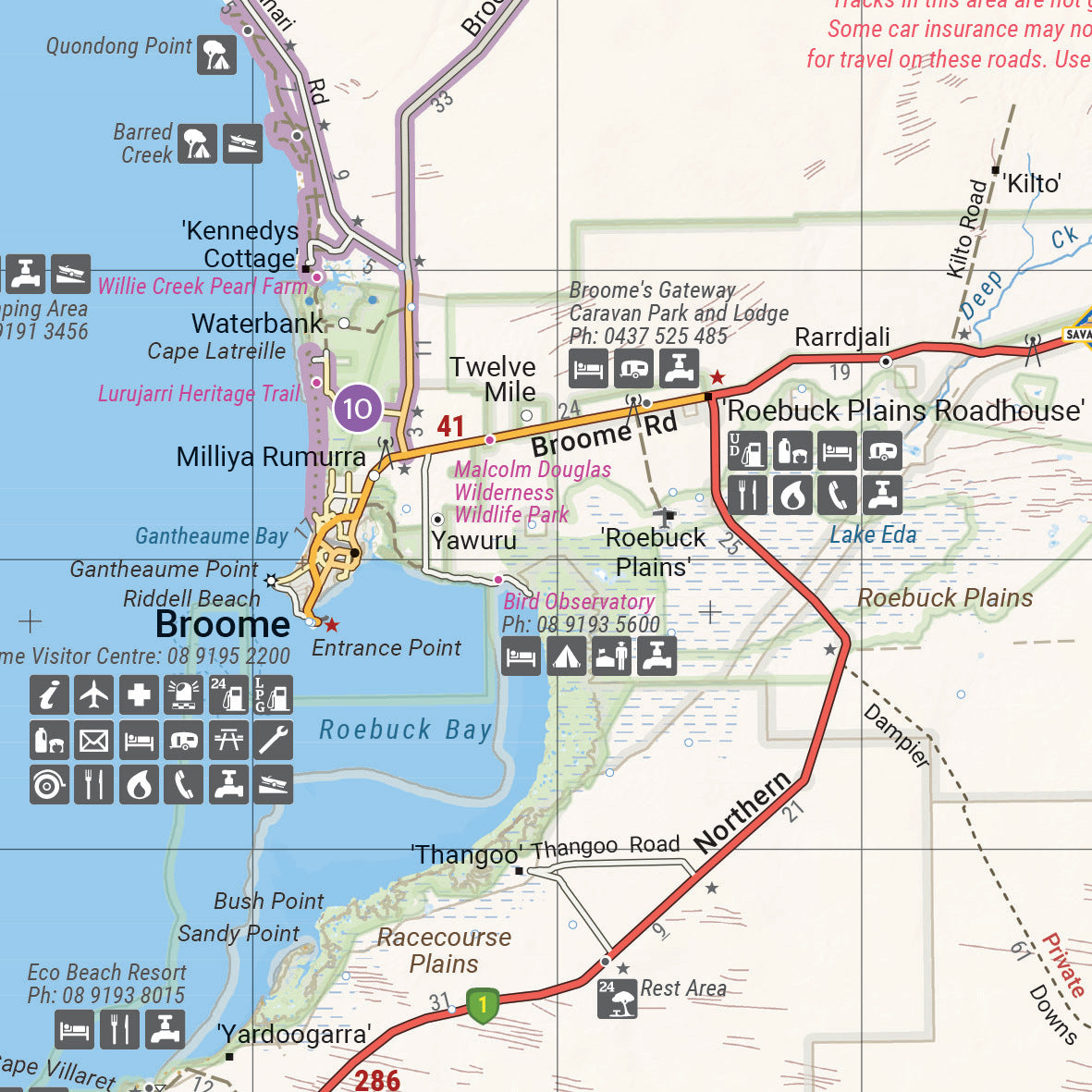
Kimberley Atlas & Guide Hema 6th Edition
$49.95
Afterpay is only available for orders between $50.00 and $1000.00 More info
The ultimate guidebook for exploring one of Australia’s last true frontiers — the breathtaking Kimberley region of Western Australia
The Kimberley Atlas & Guide (6th Edition) by Hema Maps is the most comprehensive and trusted resource available for planning and navigating a journey through the Kimberley — a remote, dramatic, and soul-stirring landscape defined by ancient gorges, vast wilderness, red rock escarpments, and powerful cultural heritage.
Created in collaboration with Australia’s most respected 4WD experts, Ron and Viv Moon, this spiral-bound guidebook combines 20 pages of new-generation Hema topographic mapping with over 200 pages of expert regional content, making it indispensable for 4WD adventurers, caravanners, campers, and off-grid explorers.
🌄 Why the Kimberley?
Few places in Australia (or the world) offer the sheer scale, geological drama, and cultural depth of the Kimberley. Stretching across more than 420,000 square kilometres in the north of Western Australia, the Kimberley is home to:
-
The iconic Gibb River Road
-
Windjana Gorge, Tunnel Creek, and Bungle Bungle Range
-
Vast stretches of wilderness with no phone signal, few towns, and endless stars
-
Indigenous rock art and Dreamtime stories spanning tens of thousands of years
-
Waterfalls, swimming holes, bush camps, and pristine coastlines
This atlas helps you make sense of it all — while also encouraging you to get off the beaten track and discover the Kimberley’s quieter corners.
🗺️ Key Features of the Guide
🔹 Top 10 4WD Adventures
-
Expertly curated by Ron and Viv Moon
-
Includes detailed track notes, distance breakdowns, travel times, track gradings, and gear recommendations
-
Covers popular and remote tracks, such as:
-
Gibb River Road
-
Kalumburu Road
-
Mitchell Plateau Track
-
Tanami Track
-
King Leopold Ranges
-
🔹 20 Detailed Atlas Maps
-
Custom Hema cartography with 4WD routes, tracks, campsites, fuel stops, water crossings, and points of interest
-
New design for enhanced clarity and readability
-
Topographic information for planning altitudes, terrain types, and travel conditions
🔹 Comprehensive Travel Guide
-
In-depth regional chapters covering:
-
The East and West Kimberley
-
Broome, Kununurra, Derby, Wyndham, and Fitzroy Crossing
-
National parks, Aboriginal communities, and major river systems
-
-
Covers both main tourist routes and remote bush escapes
-
Includes historical insights, cultural background, flora and fauna, and travel tips
🔹 Practical Advice
-
Seasonal travel guidance — especially important given the wet season road closures
-
What to pack, how to prepare your vehicle, communication and recovery options
-
Fuel availability, camping permits, safety information, and emergency contacts
📘 Specifications
-
Edition: 6th
-
Published: 15 January 2018
-
Pages: 208
-
Format: A4, spiral-bound for easy lay-flat reading
-
Size: 297 mm (H) x 210 mm (W) x 12 mm (D)
-
Weight: Approx. 955 grams
-
ISBN: 9781876413644
-
Publisher: Hema Maps
🎯 Who This Atlas Is For
-
4WD adventurers wanting reliable track info, real distances, and fuel stops
-
Caravanners and campers planning remote stays and bush camps
-
Travel writers, photographers, and tour leaders
-
Grey nomads on the Big Lap needing offline navigation tools
-
Geography buffs and educators wanting topographic reference
-
Families and couples seeking unforgettable off-grid experiences
✅ Why Choose the Hema Kimberley Atlas & Guide?
-
Created by Australia's most respected mapping and adventure experts
-
Covers hard-to-find information that GPS systems and apps often miss
-
A beautiful and tactile print guide that can travel with you — rain, dust, or shine
-
Tested in the field, updated frequently, and trusted by professionals
📦 In the Glovebox, On the Dashboard, or at the Campfire
Whether you're planning the trip of a lifetime or are already en route, the Kimberley Atlas & Guide gives you confidence, clarity, and inspiration — all in one book.
Drive smarter. Camp safer. Explore deeper. Discover more.
The Kimberley awaits. And this guide takes you there.
Frequently Asked Questions
What does the Kimberley Atlas & Guide Hema 6th Edition cover?
This atlas covers the geographic region indicated in the product title, including roads, towns, distances, and key travel information. Mapworld stocks atlases for Australian states and territories, 4WD regions, and international destinations.
Is this the latest edition?
Yes, this is the 6th Edition. Mapworld stocks the most current editions available from publishers.
Is this atlas or guide spiral bound?
Spiral binding is indicated in the product title where applicable. Spiral-bound atlases and guides lay flat when open, making them ideal for use in vehicles or on a table without needing to hold pages open.
Is the Kimberley Atlas & Guide Hema 6th Edition in stock at Mapworld?
Mapworld maintains extensive stock across its map range and aims for fast dispatch. Orders placed before 2pm AEST on business days are typically dispatched the same day, with standard and express Australia-wide delivery options available.
Does Mapworld ship the Kimberley Atlas & Guide Hema 6th Edition across Australia?
Yes, Mapworld ships Australia-wide. Standard shipping is a flat $7 rate, with free standard shipping on orders over $75. Express options are available at checkout. Most orders placed before 2pm AEST on weekdays are dispatched same day.
Related Items


© 2026 Mapworld. Website designed by Genie Media
X