- Australia ▾
- Topographic
▾
- Australia AUSTopo 250k (2024)
- Australia 50k Geoscience maps
- Australia 100k Geoscience maps
- Australia 250k Geoscience maps
- Australia 1.1m Geoscience maps
- New Zealand 50k maps
- New Zealand 250k maps
- New South Wales 25k maps
- New South Wales 50k maps
- New South Wales 100k maps
- Queensland 10k maps
- Queensland 25k maps
- Queensland 50k maps
- Queensland 100k maps
- Compasses
- Software
- GPS Systems
- Orienteering
- International ▾
- Wall Maps
▾
- World
- Australia & New Zealand
- Countries, Continents & Regions
- Historical
- Vintage National Geographic
- Australian Capital Territory
- New South Wales
- Northern Territory
- Queensland
- South Australia
- Tasmania
- Victoria
- Western Australia
- Celestial
- Children's
- Mining & Resources
- Wine Maps
- Healthcare
- Postcode Maps
- Electoral Maps
- Nautical ▾
- Flags
▾
- Australian Flag Sets & Banners
- Flag Bunting
- Handwavers
- Australian National Flags
- Aboriginal Flags
- Torres Strait Islander Flags
- International Flags
- Flagpoles & Accessories
- Australian Capital Territory Flags
- New South Wales Flags
- Northern Territory Flags
- Queensland Flags
- South Australia Flags
- Tasmania Flags
- Victoria Flags
- Western Australia Flags
- Gifts ▾
- Globes ▾
Dear valued customer. Please note that our checkout is not supported by old browsers. Please use a recent browser to access all checkout capabilities
Colour Blind Friendly World Time Zone Large Wall Map 1365 x 797mm
$79.95
or make 4 interest-free payments of
$19.99 AUD
fortnightly with
![]() More info
More info
🕒 Colour Blind Friendly World Time Zone — Large Wall Map (1365 × 797mm)
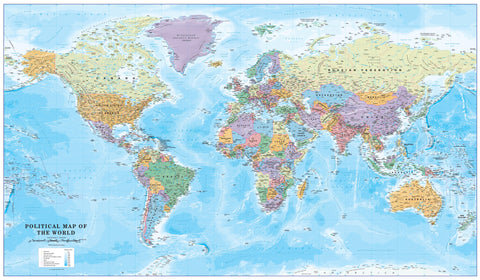
This large-format edition of our Colour Blind Friendly World Time Zone Map delivers maximum clarity and accessibility in an impressive display size. Expertly designed to work with any form of colour blindness, it uses carefully chosen contrasting tones to make global time zones easy to distinguish for everyone, both on land and at sea.
The map combines precise political cartography with functional time zone banding, and includes a dedicated inset showing countries and states that observe daylight saving hours — an essential feature for anyone coordinating international schedules.
Ideal for corporate offices, educational spaces, and shared public areas, this map ensures everyone can interpret time zone data at a glance.
🗺 Key Features
-
♿ Accessibility-Optimised Colours — Specially designed to be legible for all forms of colour blindness.
-
🌐 Political & Time Zone Integration — International borders, capitals, major cities, and clear time zone divisions.
-
🕑 Daylight Saving Reference — Dedicated inset for seasonal time changes worldwide.
-
📖 Extra-Large Display — Greater impact and readability for larger rooms.
-
🖋 Europe-Centred Projection — Perfect for European and trans-Atlantic time coordination.
📏 Specifications
| Feature | Details |
|---|---|
| Size | 1365 mm (W) × 797 mm (H) |
| Scale | 1:30,000,000 |
| Projection | Europe-Centred |
| Finish Options | Paper, Laminated, Laminated with Hang Rails, Canvas, Canvas with Hang Rails |
| Country of Manufacture | Made in Australia |
🎨 Format & Finish Options
-
📄 Heavyweight Paper (160gsm) — Sharp, clear printing; ideal for framing under glass.
-
💧 Laminated — Encapsulated in 80-micron gloss laminate for durability, water-resistance, and whiteboard use.
-
🖼 Laminated with Hang Rails — Professional presentation with natural timber rails and hanging cord.
-
🖌 Premium Canvas (395gsm HP Professional Matte) — Museum-grade texture, pigment-based fade-resistant inks.
-
🖌 Canvas with Hang Rails — Combines the elegance of canvas with the convenience of ready-to-hang timber rails.
⏳ Lead Time: Please allow up to 10 working days for hang-railed versions, as each is custom-mounted by our framer.
💡 Perfect For
-
🏢 Large Offices & Boardrooms — A clear, accessible tool for global scheduling.
-
🏫 Universities & Training Centres — Ideal for teaching geography and time coordination.
-
✈️ Travel & Logistics Operations — Perfect for aviation, shipping, and global business planning.
-
🎁 Premium Gift Option — A unique, functional present for professionals and educators.
📜 Why This Map Stands Out
This large-format colour-blind friendly design isn’t just about size — it’s about inclusivity and precision. Its enhanced scale ensures details are visible from a distance, making it ideal for big spaces, while its carefully balanced colours ensure no one is excluded from understanding its information.
Whether you’re coordinating international trade routes, teaching global geography, or simply want a striking and functional wall feature, this map delivers both beauty and clarity in equal measure.


