- Australia ▾
- Topographic
▾
- Australia AUSTopo 250k (2025)
- Australia 50k Geoscience maps
- Australia 100k Geoscience maps
- Australia 250k Geoscience maps
- Australia 1:1m Geoscience maps
- New Zealand 50k maps
- New Zealand 250k maps
- New South Wales 25k maps
- New South Wales 50k maps
- New South Wales 100k maps
- Queensland 10k maps
- Queensland 25k maps
- Queensland 50k maps
- Queensland 100k maps
- Western Australia 25k maps
- Western Australia 50k maps
- Western Australia 100k maps
- Compasses
- Software
- GPS Systems
- International ▾
- Wall Maps
▾
- World
- Australia & New Zealand
- Countries, Continents & Regions
- Historical
- Vintage National Geographic
- Australian Capital Territory
- New South Wales
- Northern Territory
- Queensland
- South Australia
- Tasmania
- Victoria
- Western Australia
- Celestial
- Children's
- Mining & Resources
- Wine Maps
- Healthcare
- Postcode Maps
- Electoral Maps
- Nautical ▾
- Flags
▾
- Australian Flag Sets & Banners
- Flag Bunting
- Handwavers
- Australian National Flags
- Aboriginal Flags
- Torres Strait Islander Flags
- International Flags
- Flagpoles & Accessories
- Australian Capital Territory Flags
- New South Wales Flags
- Northern Territory Flags
- Queensland Flags
- South Australia Flags
- Tasmania Flags
- Victoria Flags
- Western Australia Flags
- Gifts ▾
- Globes ▾
Dear valued customer. Please note that our checkout is not supported by old browsers. Please use a recent browser to access all checkout capabilities


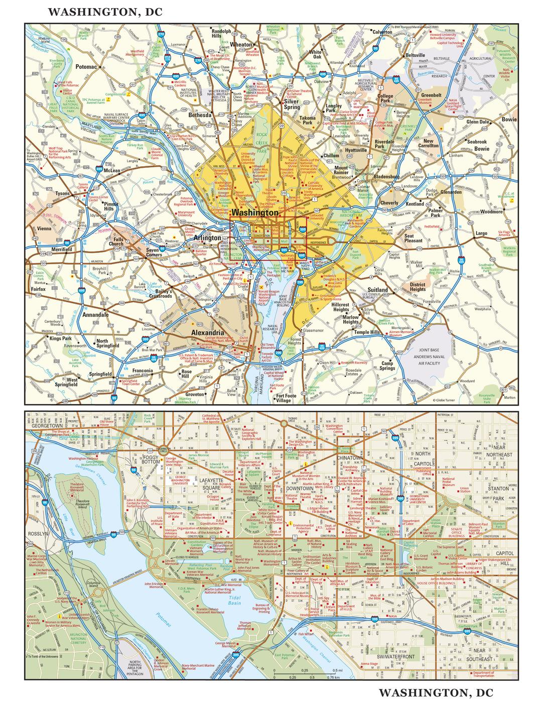
Washington DC Wall Map
$69.95
or make 4 interest-free payments of
$17.49 AUD
fortnightly with
![]() More info
More info
The Nation’s Capital – in exquisite cartographic detail
From the marble columns of the Capitol to the leafy streets of Georgetown, Washington DC is a city where history is written and the future is shaped. This beautifully designed, dual-view wall map captures both the greater Washington region and the intricate details of downtown, making it as useful as it is visually striking.
This is more than just a map — it’s a window into the heart of America. Whether you’re a history enthusiast, a teacher, a business professional, or simply someone who appreciates fine cartography, this map delivers an unmatched combination of accuracy, craftsmanship, and visual appeal.
🌟 Two Maps in One – The Complete Picture of Washington DC
Regional Overview
Covers the District of Columbia and its neighbouring Maryland and Virginia suburbs, clearly marking:
-
Cities & towns for easy location referencing
-
Highways & major roads for travel and logistics planning
-
Natural features such as rivers, parks, and recreation areas
-
Key points of interest across the broader metropolitan region
Downtown Detail
Zooms in on the historic heart of the city, from Georgetown to Capitol Hill, with precise labelling of:
-
The National Mall, The White House, and The Capitol Building
-
Smithsonian museums, monuments, and memorials
-
Arlington National Cemetery (Virginia section)
-
Neighbourhoods such as Chinatown, Foggy Bottom, Dupont Circle, and the Financial District
-
Streets, parks, landmarks, and public spaces
📌 Key Features
-
Crisp, legible cartography for both broad overviews and fine street-level detail
-
Highlights iconic landmarks known around the world
-
Up-to-date road networks and points of interest
-
Beautifully rendered shaded relief terrain for a realistic sense of topography
-
Equally suited for educational, business, travel, or decorative purposes
📐 Specifications
| Feature | Detail |
|---|---|
| Map Type | Regional & Street-Level Wall Map |
| Dimensions | 1099 mm (W) x 737 mm (H) |
| Scale | Regional overview with street-level inset |
| Publication Year | Current Edition |
| Origin | Made in Australia |
| Format Options | Paper, Laminated, Laminated with Hang Rails, Canvas, Canvas with Hang Rails |
🖌 Premium Material & Finish Options
| Format | Description |
|---|---|
| Paper (160 gsm) | Heavyweight matte-coated stock for sharp printing – perfect for framing under glass. |
| Laminated | Encapsulated in 80-micron gloss laminate – waterproof, tear-resistant, and durable for high-use environments. |
| Laminated with Hang Rails | Laminated map with elegant natural timber rails and hanging cord – ready to mount instantly. |
| Canvas (395 gsm) | Printed on HP Professional Matte Canvas using archival pigment inks – richly textured, fade-resistant, and museum-grade. |
| Canvas with Hang Rails | Combines the luxury of canvas with the ease of display using natural timber hang rails. |
🪵 Timber Hang Rails – Effortless & Elegant Display
Our lacquered natural timber hang rails transform your map into a ready-to-hang focal point. The top rail includes a strong cord for easy mounting – just one hook and it’s up.
Please note: Allow up to 10 working days for delivery of hang-railed maps, as each is professionally mounted by our framer.
🎯 Perfect For
-
History & Civics Enthusiasts – A reference tool and conversation starter.
-
Educators & Students – Brings lessons to life with clear, engaging visuals.
-
Business & Government Offices – Ideal for presentations, planning, and décor.
-
Interior Design – A sophisticated statement piece for homes and workplaces.
⭐ Why Choose This Washington DC Map?
-
Dual-perspective cartography – Get both a regional view and a detailed downtown map in one.
-
Premium build quality – Designed for longevity and visual impact.
-
Made in Australia – Produced to exacting professional print standards.
-
Versatile display options – Choose the format that suits your space and style.
The Washington DC Wall Map isn’t just a reference — it’s a timeless tribute to one of the world’s most important cities. Whether displayed in a classroom, an office, or your home, it delivers clarity, accuracy, and aesthetic appeal in equal measure.
Frequently Asked Questions
What are the dimensions of the Washington DC Wall Map?
Mapworld wall maps range from standard 700×1000mm to large-format 1000×1430mm Supermaps. The exact dimensions for this map are shown in the product title. Where multiple sizes are available, select your preferred size when adding to cart.
Is this wall map available laminated?
Many Mapworld wall maps are available in paper, laminated, or framed finishes. Check the product options when adding to cart. Laminated maps are wipe-clean and more durable.
Is this the latest edition?
Mapworld stocks the most current editions available from all publishers. Edition year is shown in the product title where applicable. Mapworld updates its catalogue as new editions are released.
Can I write on or pin this wall map?
Laminated wall maps can be written on with whiteboard markers and wiped clean. Paper maps can be pinned on a corkboard. Choose a laminated option for a writeable surface.
Does Mapworld ship the Washington DC Wall Map across Australia?
Yes, Mapworld ships Australia-wide. Standard shipping is a flat $7 rate, with free standard shipping on orders over $75. Express options are available at checkout. Most orders placed before 2pm AEST on weekdays are dispatched same day.
Related Items


© 2026 Mapworld. Website designed by Genie Media
X