- Australia ▾
- Topographic
▾
- Australia AUSTopo 250k (2025)
- Australia 50k Geoscience maps
- Australia 100k Geoscience maps
- Australia 250k Geoscience maps
- Australia 1:1m Geoscience maps
- New Zealand 50k maps
- New Zealand 250k maps
- New South Wales 25k maps
- New South Wales 50k maps
- New South Wales 100k maps
- Queensland 10k maps
- Queensland 25k maps
- Queensland 50k maps
- Queensland 100k maps
- Western Australia 25k maps
- Western Australia 50k maps
- Western Australia 100k maps
- Compasses
- Software
- GPS Systems
- International ▾
- Wall Maps
▾
- World
- Australia & New Zealand
- Countries, Continents & Regions
- Historical
- Vintage National Geographic
- Australian Capital Territory
- New South Wales
- Northern Territory
- Queensland
- South Australia
- Tasmania
- Victoria
- Western Australia
- Celestial
- Children's
- Mining & Resources
- Wine Maps
- Healthcare
- Postcode Maps
- Electoral Maps
- Nautical ▾
- Flags
▾
- Australian Flag Sets & Banners
- Flag Bunting
- Handwavers
- Australian National Flags
- Aboriginal Flags
- Torres Strait Islander Flags
- International Flags
- Flagpoles & Accessories
- Australian Capital Territory Flags
- New South Wales Flags
- Northern Territory Flags
- Queensland Flags
- South Australia Flags
- Tasmania Flags
- Victoria Flags
- Western Australia Flags
- Gifts ▾
- Globes ▾
Dear valued customer. Please note that our checkout is not supported by old browsers. Please use a recent browser to access all checkout capabilities


Nevada State Wall Map
$69.95
or make 4 interest-free payments of
$17.49 AUD
fortnightly with
![]() More info
More info
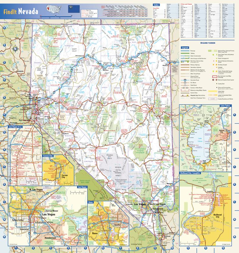
From the dazzling lights of Las Vegas to the serene expanse of the Great Basin—Nevada’s landscapes come to life in vivid cartographic detail.
This colourful, easy-to-read state map of Nevada showcases the major highways, secondary roads, freeway interchanges, rest areas, distance markers, and recreational areas that define the Silver State.
Shaded relief gives a three-dimensional sense of Nevada’s topography, revealing its sweeping deserts, mountain ranges, and iconic lakes.
Four detailed city inset maps—Carson City, Laughlin, Las Vegas, and Reno—are based on the latest street data from our expert cartographers. Additional insets of the Las Vegas Strip and Lake Tahoe highlight must-see tourist areas, complete with landmarks, attractions, and points of interest.
A county and city index makes locating even the smallest towns straightforward, and city label sizes reflect the 2020 U.S. Census for accuracy.
🌟 Key Features
-
Statewide Road Network – Major highways, secondary roads, and interchanges clearly marked.
-
Topographic Relief – Subtle shading provides a realistic sense of elevation and landscape.
-
Tourist-Focused Insets – Las Vegas Strip and Lake Tahoe maps showcase key attractions.
-
Detailed City Insets – Carson City, Laughlin, Las Vegas, and Reno in precise street detail.
-
Recreational & Natural Highlights – State parks, recreation areas, lakes, and landmarks.
-
Indexed Counties & Cities – Quick reference for both residents and visitors.
📐 Specifications
| Feature | Detail |
|---|---|
| Map Type | State Wall Map – Nevada |
| Dimensions | 942 mm (W) x 1000 mm (H) |
| Scale | Detailed state coverage with city and tourist insets |
| Publication Year | Current, based on latest cartographic updates |
| Finish Options | Paper, Laminated, Laminated with Hang Rails, Canvas, Canvas with Hang Rails |
| Origin | Made in Australia |
🖌 Material & Finish Options
| Format | Description |
|---|---|
| Paper (160 gsm) | Heavyweight matte-coated paper – perfect for framing under glass. |
| Laminated | Encapsulated in 80-micron gloss laminate – waterproof, tear-resistant, and ideal for regular handling. |
| Laminated with Hang Rails | Includes natural timber rails and hanging cord – ready to display. |
| Canvas (395 gsm) | HP Professional Matte Canvas with archival pigment inks – richly textured, fade-resistant, and long-lasting. |
| Canvas with Hang Rails | Adds elegant timber hang rails for a premium ready-to-hang finish. |
🪵 Wooden Hang Rails – Elegant & Practical
Our lacquered natural timber hang rails give your map a professional presentation. The top rail includes a hanging cord for easy wall mounting, and the finish complements both modern and classic interiors.
Note: Please allow up to 10 working days for hang-railed maps, as each is custom-mounted by our framer.
🎯 Perfect For
-
Home & Office Décor – A stylish conversation piece with practical reference value.
-
Tourism & Hospitality – Perfect for hotels, visitor centres, and travel agencies.
-
Education – A great resource for geography, history, and tourism studies.
-
Business & Planning – Ideal for logistics, events, and territory mapping.
-
Collectors – A high-quality addition to any U.S. state map collection.
📍 About Nevada – The Silver State at a Glance
Nevada is a land of extremes—home to bustling entertainment hubs, quiet desert towns, and some of the most breathtaking natural scenery in the American West. From Lake Tahoe’s alpine beauty to the Mojave Desert’s vast silence, this wall map captures both the urban vibrancy and wild solitude that make Nevada unique.
Frequently Asked Questions
What are the dimensions of the Nevada State Wall Map?
Mapworld wall maps range from standard 700×1000mm to large-format 1000×1430mm Supermaps. The exact dimensions for this map are shown in the product title. Where multiple sizes are available, select your preferred size when adding to cart.
Is this wall map available laminated?
Many Mapworld wall maps are available in paper, laminated, or framed finishes. Check the product options when adding to cart. Laminated maps are wipe-clean and more durable.
Is this the latest edition?
Mapworld stocks the most current editions available from all publishers. Edition year is shown in the product title where applicable. Mapworld updates its catalogue as new editions are released.
Can I write on or pin this wall map?
Laminated wall maps can be written on with whiteboard markers and wiped clean. Paper maps can be pinned on a corkboard. Choose a laminated option for a writeable surface.
Does Mapworld ship the Nevada State Wall Map across Australia?
Yes, Mapworld ships Australia-wide. Standard shipping is a flat $7 rate, with free standard shipping on orders over $75. Express options are available at checkout. Most orders placed before 2pm AEST on weekdays are dispatched same day.
Related Items


© 2026 Mapworld. Website designed by Genie Media
X