- Australia ▾
- Topographic
▾
- Australia AUSTopo 250k (2024)
- Australia 50k Geoscience maps
- Australia 100k Geoscience maps
- Australia 250k Geoscience maps
- Australia 1.1m Geoscience maps
- New Zealand 50k maps
- New Zealand 250k maps
- New South Wales 25k maps
- New South Wales 50k maps
- New South Wales 100k maps
- Queensland 10k maps
- Queensland 25k maps
- Queensland 50k maps
- Queensland 100k maps
- Compasses
- Software
- GPS Systems
- Orienteering
- International ▾
- Wall Maps
▾
- World
- Australia & New Zealand
- Countries, Continents & Regions
- Historical
- Vintage National Geographic
- Australian Capital Territory
- New South Wales
- Northern Territory
- Queensland
- South Australia
- Tasmania
- Victoria
- Western Australia
- Celestial
- Children's
- Mining & Resources
- Wine Maps
- Healthcare
- Postcode Maps
- Electoral Maps
- Nautical ▾
- Flags
▾
- Australian Flag Sets & Banners
- Flag Bunting
- Handwavers
- Australian National Flags
- Aboriginal Flags
- Torres Strait Islander Flags
- International Flags
- Flagpoles & Accessories
- Australian Capital Territory Flags
- New South Wales Flags
- Northern Territory Flags
- Queensland Flags
- South Australia Flags
- Tasmania Flags
- Victoria Flags
- Western Australia Flags
- Gifts ▾
- Globes ▾
Dear valued customer. Please note that our checkout is not supported by old browsers. Please use a recent browser to access all checkout capabilities
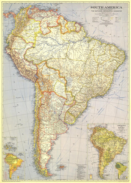
South America Wall Map - Published 1937 by National Geographic
$69.95
or make 4 interest-free payments of
$17.49 AUD
fortnightly with
![]() More info
More info
Scale: 1:8,500,000 | Published: December 1937 | Made in Australia
🌎 A Continent on the Brink of Change
When National Geographic released this December 1937 edition of its South America wall map, much of the continent was still a remote wilderness — roadless interiors, uncharted tributaries, and entire stretches of rainforest yet to be fully explored. The great cities of the coast—Buenos Aires, Rio de Janeiro, Lima—stood as gateways to an interior that was as mysterious as it was magnificent.
This map captures that moment in time with vivid colour and meticulous cartography, providing not just political borders and place names, but a geographical portrait of an untamed continent. Insets of the Galapagos Islands reveal a world soon to become famous for its role in the story of evolution, while carefully drawn annotations share information on precipitation, temperature, airways, and relief, offering a multi-dimensional view of the region in the late 1930s.
📜 Historical Significance
-
1930s South America – Before the age of mass highways and large-scale deforestation, this map presents the continent at a unique point in its modern history.
-
Comprehensive Insets – Includes the Galapagos Islands, climate data, and air routes, reflecting both scientific and exploratory priorities of the era.
-
Artistry & Accuracy – Classic National Geographic style with shaded relief and bold, easy-to-read labelling.
📐 Map Specifications
-
Scale: 1:8,500,000
-
Size: Faithfully reproduced to match the original proportions.
-
Projection: Designed for clarity, readability, and visual harmony.
-
Print Quality: High-resolution reproduction capturing every nuance of the 1937 printing.
🖌 Premium Finishing Options
| Format | Description |
|---|---|
| Paper (160 gsm) | Heavyweight matte-coated paper — ideal for framing under glass. |
| Laminated | Fully encapsulated in 80-micron gloss laminate for durability and easy cleaning. |
| Laminated + Hang Rails | Ready-to-hang with natural timber rails and a cord — perfect for instant display. |
| Canvas (395 gsm) | Museum-grade matte canvas, printed with archival pigment inks for exceptional texture and fade resistance. |
| Canvas + Hang Rails | Canvas with timber hang rails for a warm, heritage-style finish. |
Framing Note: Please allow up to 10 working days for delivery of hang-railed maps, as each is custom-mounted by our framer.
🎯 Perfect For
-
Historians & Collectors – A rare glimpse of South America before major industrial expansion.
-
Educators – Brings historical geography to life in the classroom.
-
Travel Enthusiasts – Inspires journeys to legendary landscapes and cultural centres.
-
Interior Spaces – Adds depth, heritage, and conversation value to offices, libraries, or living rooms.
🌟 Why This Map Belongs in Your Collection
-
Captures pre-modern South America in extraordinary detail.
-
Combines visual beauty with historical insight.
-
Available in multiple premium formats to suit your space.
-
Made in Australia with archival materials for lasting quality.
Bring home a faithful reproduction of one of National Geographic’s most captivating maps. Whether for study, décor, or heritage value, this 1937 edition invites you to see South America as the world once did — mysterious, colourful, and untamed.
🛒 Order today and make this piece of cartographic history your own.


