- Australia ▾
- Topographic
▾
- Australia AUSTopo 250k (2024)
- Australia 50k Geoscience maps
- Australia 100k Geoscience maps
- Australia 250k Geoscience maps
- Australia 1.1m Geoscience maps
- New Zealand 50k maps
- New Zealand 250k maps
- New South Wales 25k maps
- New South Wales 50k maps
- New South Wales 100k maps
- Queensland 10k maps
- Queensland 25k maps
- Queensland 50k maps
- Queensland 100k maps
- Compasses
- Software
- GPS Systems
- Orienteering
- International ▾
- Wall Maps
▾
- World
- Australia & New Zealand
- Countries, Continents & Regions
- Historical
- Vintage National Geographic
- Australian Capital Territory
- New South Wales
- Northern Territory
- Queensland
- South Australia
- Tasmania
- Victoria
- Western Australia
- Celestial
- Children's
- Mining & Resources
- Wine Maps
- Healthcare
- Postcode Maps
- Electoral Maps
- Nautical ▾
- Flags
▾
- Australian Flag Sets & Banners
- Flag Bunting
- Handwavers
- Australian National Flags
- Aboriginal Flags
- Torres Strait Islander Flags
- International Flags
- Flagpoles & Accessories
- Australian Capital Territory Flags
- New South Wales Flags
- Northern Territory Flags
- Queensland Flags
- South Australia Flags
- Tasmania Flags
- Victoria Flags
- Western Australia Flags
- Gifts ▾
- Globes ▾
Dear valued customer. Please note that our checkout is not supported by old browsers. Please use a recent browser to access all checkout capabilities


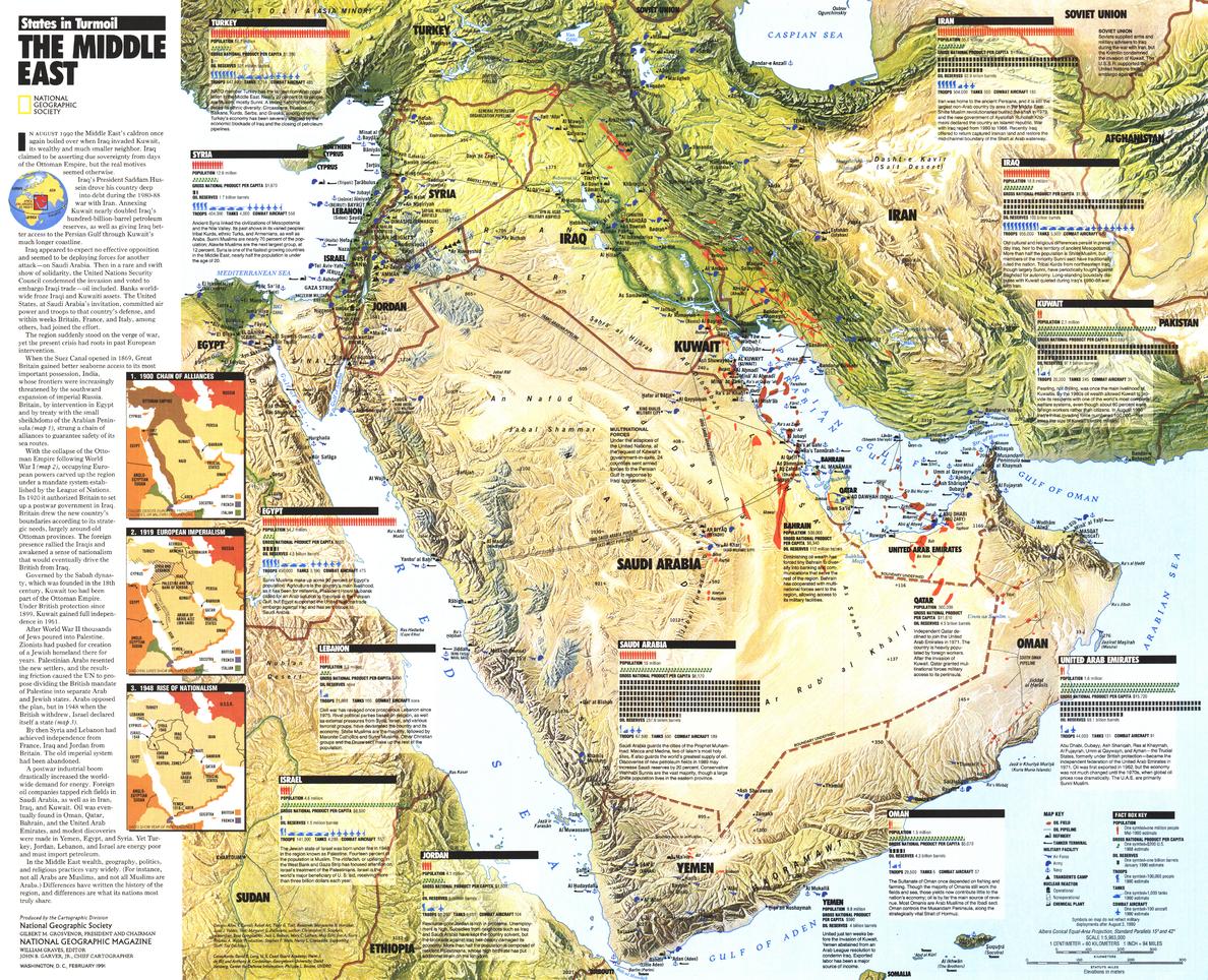
Middle East, States in Turmoil Wall Map - Published 1991 by National Geographic
$49.95
Afterpay is only available for orders between $50.00 and $1000.00 More info
🌍 Middle East, States in Turmoil Wall Map – National Geographic
Scale 1:5,963,000 | Published February 1991 | Gulf War Historical Context
Published in February 1991 by National Geographic, the Middle East, States in Turmoil Wall Map offers a detailed and timely view of the region during one of the most critical geopolitical periods of the late 20th century — the Gulf War.
Designed as a political and thematic reference, this map goes beyond borders and place names, presenting a wealth of country-by-country data, including:
-
Military facilities and troop numbers
-
Oil reserves and production
-
Population statistics
-
Gross national product (GNP)
-
Strategic locations and infrastructure
An overview of the Gulf War is also included, providing essential historical context. Originally issued as a supplement to National Geographic’s The Middle East wall map, this edition is both an educational resource and a collectible historical record.
🗺️ Map Features
-
Political Boundaries – Countries, capitals, major cities, and key borders as of 1991.
-
Thematic Data – Military, economic, and demographic information for each nation.
-
Gulf War Overview – Summary of events, alliances, and outcomes.
-
Strategic Infrastructure – Military bases, oil fields, and transport routes.
-
National Geographic Cartography – Accuracy, clarity, and visually engaging design.
✨ Available Finishes
| Format | Description |
|---|---|
| 🖨️ Paper (160 gsm) | Heavyweight matte-coated paper — perfect for framing under glass. |
| 🧼 Laminated (Encapsulated) | Sealed between two sheets of 80-micron gloss laminate for a wipe-clean, tear-resistant finish. |
| 🪵 Laminated with Wooden Hang Rails | Laminated map mounted with natural lacquered timber rails (top and bottom) and a hanging cord — ready to hang. |
| 🖼️ Canvas (395 gsm) | HP Professional Matte Canvas with archival pigment-based inks. Rich in texture, fade-resistant, and gallery-quality. |
| 🪵 Canvas with Wooden Hang Rails | Canvas mounted with natural timber rails and a hanging cord for a timeless, display-ready look. |
🔨 Please allow up to 10 working days for delivery of hang-railed maps, as these are professionally mounted by our custom framer.
📐 Specifications
| Feature | Detail |
|---|---|
| Title | Middle East, States in Turmoil Wall Map |
| Publisher | National Geographic |
| Published | February 1991 |
| Scale | 1:5,963,000 |
| Dimensions | 629 mm (W) x 510 mm (H) |
| Materials | 160 gsm paper / 80-micron gloss laminate / 395 gsm HP Matte Canvas |
| Origin | Printed and professionally finished in Australia |
💡 Why You’ll Love This Map
✔️ Captures the Middle East during the Gulf War — a pivotal moment in recent history
✔️ Rich in military, economic, and demographic data
✔️ National Geographic design and accuracy
✔️ Available in five premium finishes — from frame-ready to instant wall display
✔️ Printed with fade-resistant inks for decades of clarity
🎯 Perfect For
-
Educational Institutions – Political science, history, and geography classrooms
-
Libraries & Archives – A historical record of the early 1990s Middle East
-
Corporate & Government Offices – Strategic and historical reference
-
Collectors – A preserved National Geographic Gulf War-era map
-
Home Display – For history enthusiasts and geopolitical scholars
🚚 Delivery
-
Paper, Laminated, Canvas: Ships within 1–2 business days
-
Hang-railed Maps (Laminated or Canvas): Ships within 10 working days (custom-mounted)
-
Packaging: Rolled in a heavy-duty postal tube for safe arrival
This Middle East, States in Turmoil Wall Map is both a historical artefact and an informative reference, capturing the political and military realities of the region at the height of the Gulf War.
👉 Order today to own a cartographic record of a defining moment in modern Middle Eastern history.


