Campaigns, Timelines & Turning Points — Battles of the Civil War (2012)
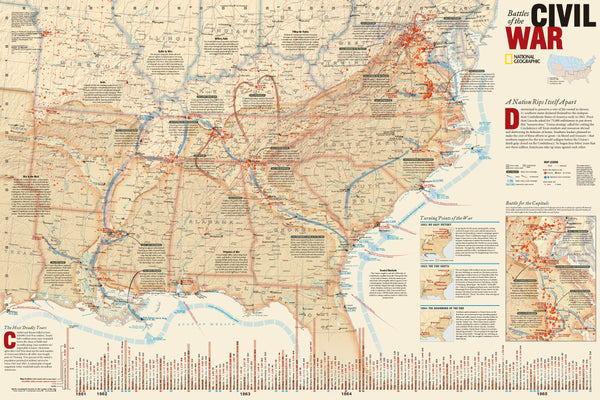
A modern master-reference to the American Civil War. This comprehensive National Geographic wall map synthesizes major land campaigns, Union & Confederate troop movements, Union naval operations, roads and railroads, and battle outcomes—with dates of capture, consequences, and context across the entire theater. Two incisive insets—Battle for the Capitals and Turning Points of the War—pair with a detailed timeline of engagements (locations, casualties, and impacts) to make strategy and sequence unmistakably clear.
Created with expert input from the National Park Service, Civil War Preservation Trust, American Battlefield Protection Program, Naval Historical Center, Virginia War Museum, National Museum of Civil War Medicine, and the U.S. Naval Academy.
More Than a Map – A Teaching & Research Tool
Built for educators, historians, reenactors, designers, and collectors, this sheet brings coherence to a complex conflict. At room distance, trace campaigns and theater-wide shifts; up close, study timelines, lines of march, and decisive moments that shaped the outcome.
Hang it in classrooms, libraries, museums, studios, offices, or at home to turn study into discovery.
Premium Materials & Finishes
We treat history with the respect it deserves. That’s why we offer multiple formats, each produced with high-quality materials and modern archival printing.
🌟 Archival Paper Print
Printed on heavyweight 160gsm archival-grade paper.
Smooth matte finish for crisp labels and reduced glare—ideal for framing under glass.
💎 Laminated Edition
Encapsulated in two sheets of 80-micron gloss laminate (true thermal bonding).
Durable, moisture-resistant, and wipe-clean—perfect for classrooms and high-traffic spaces.
Optional Natural Timber Hang Rails: lacquered with fitted hanging cord for a polished, ready-to-hang presentation. (Please allow up to 10 working days for delivery with hang rails.)
🏆 Museum-Quality Canvas
Printed on heavyweight 395gsm HP Professional Matte Canvas for rich texture and longevity.
Pigment-based, fade-resistant inks keep tones deep and typography sharp for years.
Optional Natural Timber Hang Rails: lacquered to enhance the grain; top cord for effortless hanging. (Please allow up to 10 working days for delivery with hang rails.)
Specifications
| Feature | Details |
|---|---|
| Title | Battles of the Civil War |
| Publisher | National Geographic |
| Original Publication | 2012 |
| Scale | 1:2,550,000 |
| Cartographic Content | Major land campaigns; Union/Confederate troop movements; Union naval campaigns; roads; railroads; battle outcomes & dates |
| Insets & Extras | Battle for the Capitals; Turning Points of the War; timeline with locations, casualties & impacts |
| Expert Partners | NPS, CWPT, ABPP, Naval Historical Center, Virginia War Museum, National Museum of Civil War Medicine, U.S. Naval Academy |
| Map Size | 914 mm (W) × 610 mm (H) |
| Available Formats | Paper, Laminated, Canvas |
| Paper Weight | 160gsm archival-quality |
| Laminate | 2 × 80-micron gloss laminate sheets (encapsulated) |
| Canvas Weight | 395gsm HP Professional Matte Canvas |
| Inks | Pigment-based, fade-resistant |
| Optional Hang Rails | Available on Laminated & Canvas (lead time up to 10 working days) |
| Origin | Made in Australia |
Why Choose This Map
✔ All-in-One Overview: Campaigns, movements, outcomes, and naval operations unified on a single, legible sheet.
✔ Context You Can Teach: Inset analyses and a battle timeline translate complexity into clarity.
✔ Authoritative & Collaborative: Produced with leading archives, museums, and preservation programs.
✔ Decorative & Scholarly: Striking wall presence with genuine reference depth.
✔ Archival Craft: Premium stocks and inks protect fine linework and label contrast for decades.
Our Commitment
We believe that preserving history is as important as telling it. Every map is printed locally in Australia using state-of-the-art technology, carefully inspected by hand, and packed with care. From our workshop to your wall, we deliver quality you can trust—and a legacy you’ll be proud to share.
Trace the campaigns, study the turning points, and see the war’s arc at a glance. Order the Battles of the Civil War (2012) today—a faithful, beautifully produced map that turns any room into a conversation.


