- Australia ▾
- Topographic
▾
- Australia AUSTopo 250k (2025)
- Australia 50k Geoscience maps
- Australia 100k Geoscience maps
- Australia 250k Geoscience maps
- Australia 1:1m Geoscience maps
- New Zealand 50k maps
- New Zealand 250k maps
- New South Wales 25k maps
- New South Wales 50k maps
- New South Wales 100k maps
- Queensland 10k maps
- Queensland 25k maps
- Queensland 50k maps
- Queensland 100k maps
- Western Australia 25k maps
- Western Australia 50k maps
- Western Australia 100k maps
- Compasses
- Software
- GPS Systems
- International ▾
- Wall Maps
▾
- World
- Australia & New Zealand
- Countries, Continents & Regions
- Historical
- Vintage National Geographic
- Australian Capital Territory
- New South Wales
- Northern Territory
- Queensland
- South Australia
- Tasmania
- Victoria
- Western Australia
- Celestial
- Children's
- Mining & Resources
- Wine Maps
- Healthcare
- Postcode Maps
- Electoral Maps
- Nautical ▾
- Flags
▾
- Australian Flag Sets & Banners
- Flag Bunting
- Handwavers
- Australian National Flags
- Aboriginal Flags
- Torres Strait Islander Flags
- International Flags
- Flagpoles & Accessories
- Australian Capital Territory Flags
- New South Wales Flags
- Northern Territory Flags
- Queensland Flags
- South Australia Flags
- Tasmania Flags
- Victoria Flags
- Western Australia Flags
- Gifts ▾
- Globes ▾
Dear valued customer. Please note that our checkout is not supported by old browsers. Please use a recent browser to access all checkout capabilities


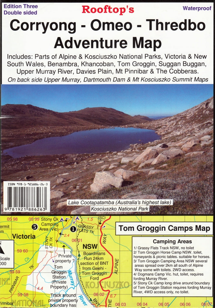
Corryong - Omeo - Thredbo Adventure Map Rooftop
$14.95 $15.95
Afterpay is only available for orders between $50.00 and $1000.00 More info
Waterproof. Detailed. Designed for the Alpine Explorer.
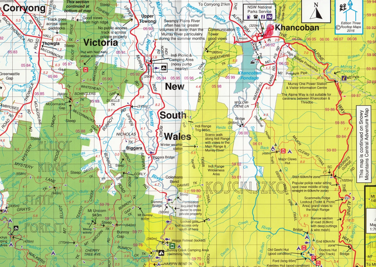
The third edition of the Corryong - Omeo - Thredbo Adventure Map by Rooftop Maps is a highly detailed, field-verified topographic and touring map designed for 4WD enthusiasts, hikers, campers, and backcountry adventurers. Covering some of Australia's most iconic high country terrain, this map is an essential companion for anyone exploring the Victorian and NSW Alpine regions.
🗺️ Areas Covered
This map covers a vast and rugged area, including:
-
Towns & Localities: Corryong, Khancoban, Nariel, Benambra, Omeo, Suggan Buggan, Thredbo
-
Scenic Routes & Wilderness Areas: Tom Groggin, Pinninbar, The Cobberas, Cowombat Flat, Davies Plain
-
National Parks & Waterways: Kosciuszko National Park, Alpine National Park, Upper Murray River
-
Camping & Access Points: Taylors Crossing, Glen Dart, Wulgulmerang
🔍 Reverse Side Insets
The back of the map features three inset maps for even more focused detail:
-
Dartmouth Dam
-
Upper Murray region
-
Mount Kosciuszko Summit Access (with detailed summit trail information)
These inset maps are perfect for planning high country routes and pinpointing campgrounds, lookouts, trailheads, and river crossings.
🧾 Map Features
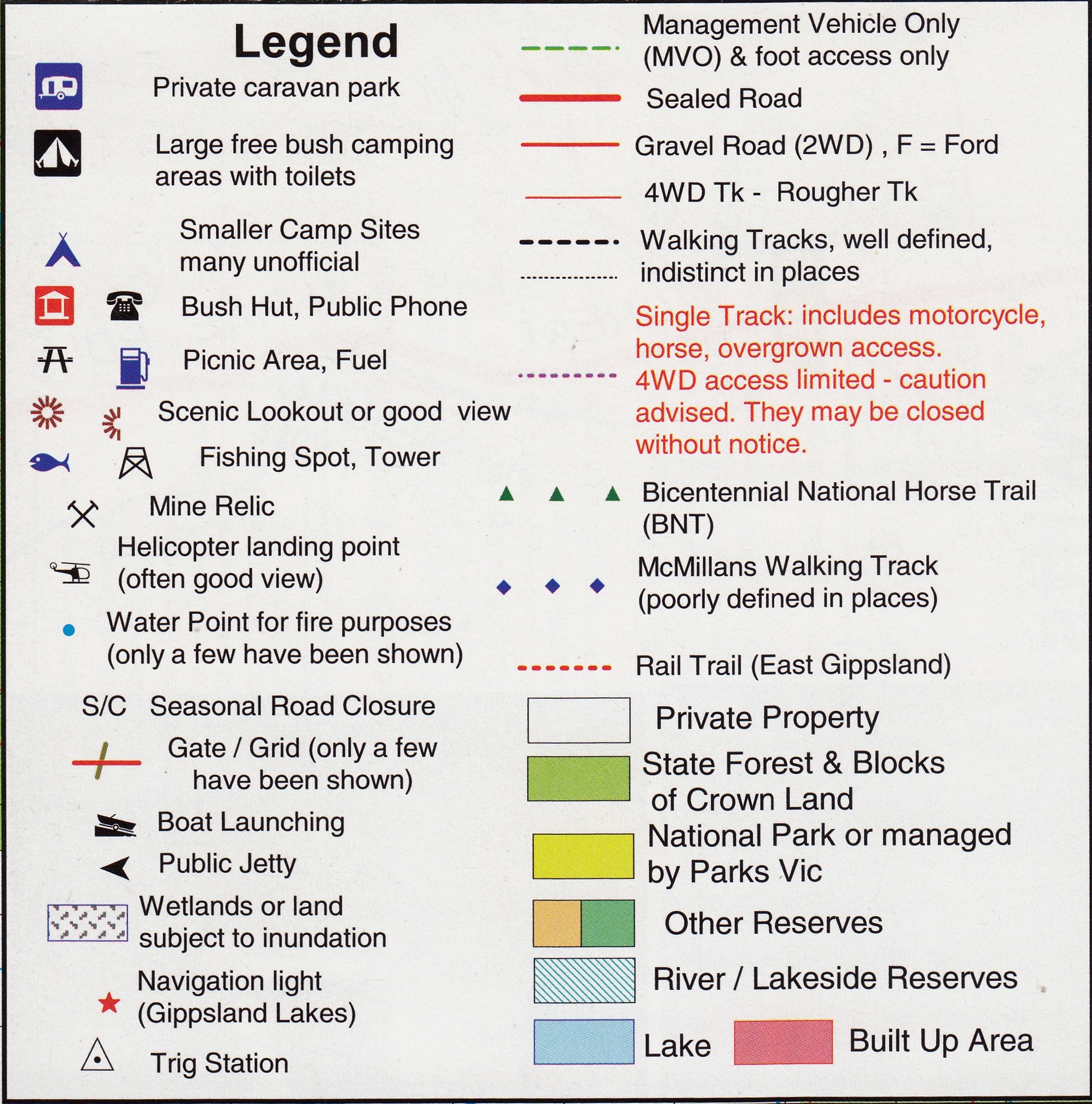
-
🛰️ GPS-Sourced Accuracy – All roads, trails, and topographic features have been precisely mapped using GPS fieldwork
-
🌲 Parks & Forests Clearly Marked – Includes national parks, state forests, conservation areas, and reserves
-
🛣️ Road Types Differentiated – Sealed roads, 4WD tracks, seasonal trails, and walking tracks all clearly distinguished
-
🏕️ Campsites & Points of Interest – Lookouts, huts, picnic areas, river access points, and more
💧 Printed for the Outdoors
This edition is printed on waterproof, tear-resistant synthetic paper — tough enough for any Alpine expedition. Whether you're planning a trip through the Davies Plain Track or navigating the backroads to Omeo, this map will withstand the elements.
🧼 Need something erasable? We also offer laminated versions:
-
Use whiteboard markers to plan routes
-
Apply map dots to mark campsites or tracks without permanent marks
-
Laminate adds long-term durability and stain protection
📐 Specifications
| Feature | Detail |
|---|---|
| Map Type | Adventure / Touring Map |
| Edition | 3rd Edition |
| Scale | 1:100,000 (main) / 1:50,000 (insets) |
| Sheet Size | 700 mm x 1000 mm |
| Material | Waterproof synthetic paper (optional laminated finish available) |
| Publisher | Rooftop Maps |
🧭 Ideal For:
-
4WD drivers tackling remote Victorian high country tracks
-
Bushwalkers and hikers summiting Mount Kosciuszko
-
Tourers exploring alpine backroads, rivers, and valleys
-
Campers, anglers, and outdoor photographers
-
Emergency services and backcountry guides
📦 Shipping Notes
All maps are securely rolled and shipped in protective tubes. Laminated versions may take an additional 1–2 days for custom finishing.
Get ready to explore the breathtaking alpine wilderness of Victoria and New South Wales with confidence. The Corryong - Omeo - Thredbo Adventure Map gives you the detail, accuracy, and durability you need to roam far and wide.
Frequently Asked Questions
Where can I buy the Corryong - Omeo - Thredbo Adventure Map Rooftop?
The Corryong - Omeo - Thredbo Adventure Map Rooftop is available to buy online from Mapworld, Australia's largest map and geographic product retailer, with fast shipping Australia-wide.
Is the Corryong - Omeo - Thredbo Adventure Map Rooftop in stock at Mapworld?
Mapworld maintains extensive stock across its map range and aims for fast dispatch. Orders placed before 2pm AEST on business days are typically dispatched the same day, with standard and express Australia-wide delivery options available.
What is Mapworld's returns policy?
Mapworld accepts returns on undamaged items in original condition. Contact Mapworld within 90 days of purchase to arrange a return or exchange.
Does Mapworld ship the Corryong - Omeo - Thredbo Adventure Map Rooftop across Australia?
Yes, Mapworld ships Australia-wide. Standard shipping is a flat $7 rate, with free standard shipping on orders over $75. Express options are available at checkout. Most orders placed before 2pm AEST on weekdays are dispatched same day.
Related Items


© 2026 Mapworld. Website designed by Genie Media
X