- Australia ▾
- Topographic
▾
- Australia AUSTopo 250k (2025)
- Australia 50k Geoscience maps
- Australia 100k Geoscience maps
- Australia 250k Geoscience maps
- Australia 1:1m Geoscience maps
- New Zealand 50k maps
- New Zealand 250k maps
- New South Wales 25k maps
- New South Wales 50k maps
- New South Wales 100k maps
- Queensland 10k maps
- Queensland 25k maps
- Queensland 50k maps
- Queensland 100k maps
- Western Australia 25k maps
- Western Australia 50k maps
- Western Australia 100k maps
- Compasses
- Software
- GPS Systems
- International ▾
- Wall Maps
▾
- World
- Australia & New Zealand
- Countries, Continents & Regions
- Historical
- Vintage National Geographic
- Australian Capital Territory
- New South Wales
- Northern Territory
- Queensland
- South Australia
- Tasmania
- Victoria
- Western Australia
- Celestial
- Children's
- Mining & Resources
- Wine Maps
- Healthcare
- Postcode Maps
- Electoral Maps
- Nautical ▾
- Flags
▾
- Australian Flag Sets & Banners
- Flag Bunting
- Handwavers
- Australian National Flags
- Aboriginal Flags
- Torres Strait Islander Flags
- International Flags
- Flagpoles & Accessories
- Australian Capital Territory Flags
- New South Wales Flags
- Northern Territory Flags
- Queensland Flags
- South Australia Flags
- Tasmania Flags
- Victoria Flags
- Western Australia Flags
- Gifts ▾
- Globes ▾
Dear valued customer. Please note that our checkout is not supported by old browsers. Please use a recent browser to access all checkout capabilities


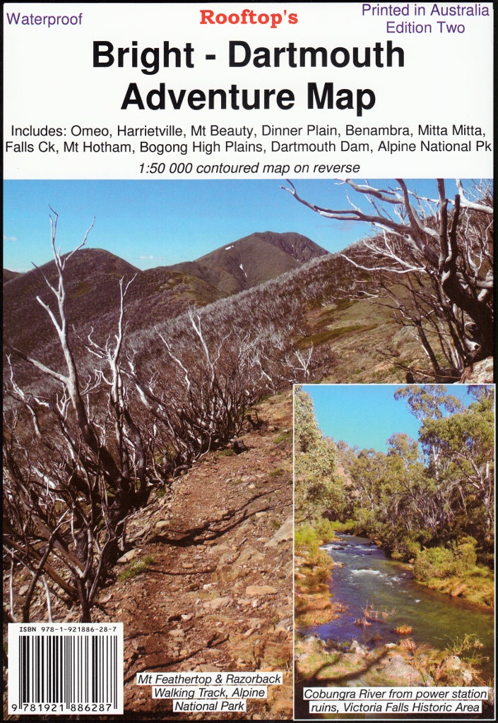
Bright - Dartmouth Adventure Map Rooftop
$14.95 $15.95
Afterpay is only available for orders between $50.00 and $1000.00 More info
Navigate Victoria's High Country with Confidence
Embark on your next adventure with the Bright – Dartmouth Adventure Map, meticulously crafted by Rooftop Maps. This comprehensive, double-sided map is designed for 4WD enthusiasts, hikers, campers, and outdoor explorers seeking to navigate the stunning terrains of Victoria's High Country with confidence.
🗺️ Coverage Highlights
This map encompasses a vast region, including:
-
Towns & Villages: Bright, Omeo, Harrietville, Mount Beauty, Dederang, Mitta Mitta, Benambra, Anglers Rest, Glen Valley, Dinner Plain.
-
Natural Landmarks: Mount Feathertop, Falls Creek, Victoria Falls, Lake Dartmouth, Dartmouth Dam, Bogong High Plains, Mount Hotham.
-
Protected Areas: Alpine National Park and surrounding state forests.
Whether you're planning a scenic drive, a challenging hike, or a camping trip, this map provides the detailed information you need.
🧭 Map Features
-
Dual Scale Mapping:
-
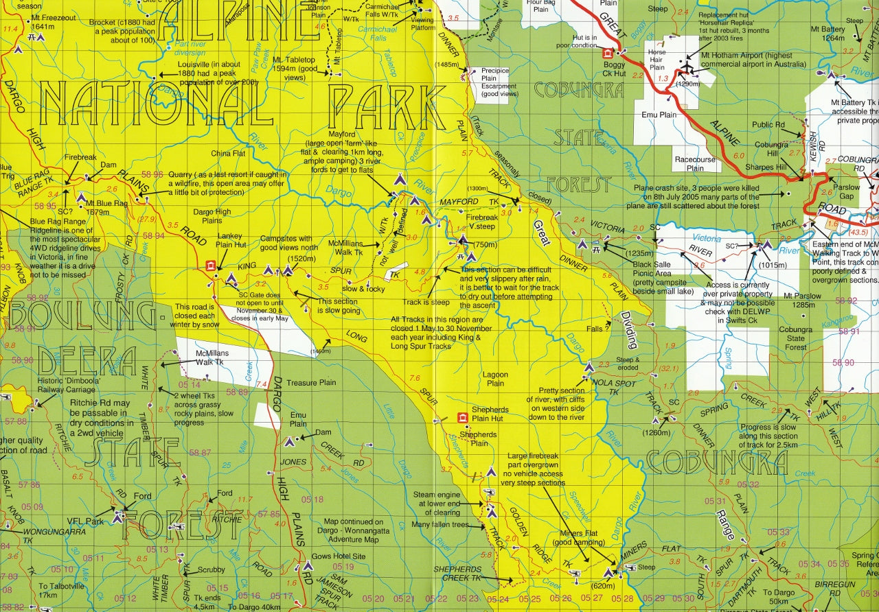
Front: 1:100,000 scale for broad regional navigation.
-
Reverse: 1:50,000 scale Forest Activities Map focusing on the Bogong, Bright, and Mount Hotham regions, complete with 20-meter contour intervals for precise elevation insights.
-
-
4WD Routes: Recommended tracks through Lake Dartmouth, Mayford, Mitta Mitta, Anglers Rest, and Glen Wills, catering to both novice and experienced off-road drivers.
-
Bush Huts Inset: A pictorial guide showcasing 37 historic bush huts, offering a glimpse into the area's rich heritage.
-
Recreational Details: Information on walking tracks, cycling trails, camping sites, fishing spots, and points of interest.
-
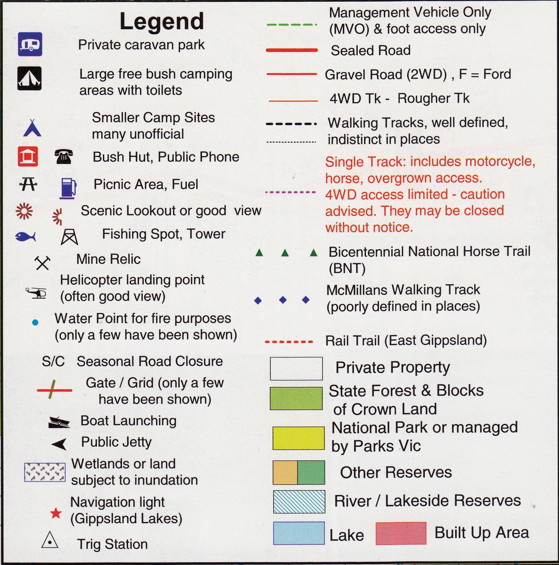
Topographic Accuracy: Clear depiction of road and forest track information, forest reserves, park boundaries, and more.
💧 Durability & Usability
-
Waterproof & Tear-Resistant: Printed on high-quality waterproof paper, ensuring resilience against the elements—ideal for outdoor use in varying weather conditions.
-
Laminated Option: Enhance durability with a laminated finish, allowing you to:
-
Write on the map using whiteboard markers.
-
Apply map dots to mark locations of interest.
-
Easily wipe clean without leaving permanent marks.
-
Protect against tears, stains, and UV damage.
-
📏 Specifications
-
Edition: 2nd Edition (2018)
-
Dimensions: 700 mm (W) x 1000 mm (H)
-
Folded Size: 145 mm x 205 mm
-
Map Datum: WGS 84 Zone 55H
-
ISBN: 9781921886287
-
Weight: Approximately 95 grams
🧭 Ideal For
-
4WD Enthusiasts: Navigate challenging tracks with confidence.
-
Hikers & Campers: Plan routes and locate campsites with ease.
-
Cyclists: Discover cycling trails suited to various skill levels.
-
Fishermen: Identify prime fishing locations.
-
History Buffs: Explore historic bush huts and learn about the region's past.
🚚 Shipping & Availability
-
Delivery: Ships rolled or flat-packed, depending on the selected finish.
-
Lamination: Available upon request; please allow additional time for processing.
-
Shipping Time: Standard delivery within Australia; expedited options available at checkout.
Equip yourself with the Bright – Dartmouth Adventure Map and experience Victoria's High Country like never before. Whether you're venturing off-road, hiking alpine trails, or exploring historic sites, this map is your trusted companion.
Frequently Asked Questions
Where can I buy the Bright - Dartmouth Adventure Map Rooftop?
The Bright - Dartmouth Adventure Map Rooftop is available to buy online from Mapworld, Australia's largest map and geographic product retailer, with fast shipping Australia-wide.
Is the Bright - Dartmouth Adventure Map Rooftop in stock at Mapworld?
Mapworld maintains extensive stock across its map range and aims for fast dispatch. Orders placed before 2pm AEST on business days are typically dispatched the same day, with standard and express Australia-wide delivery options available.
What is Mapworld's returns policy?
Mapworld accepts returns on undamaged items in original condition. Contact Mapworld within 90 days of purchase to arrange a return or exchange.
Does Mapworld ship the Bright - Dartmouth Adventure Map Rooftop across Australia?
Yes, Mapworld ships Australia-wide. Standard shipping is a flat $7 rate, with free standard shipping on orders over $75. Express options are available at checkout. Most orders placed before 2pm AEST on weekdays are dispatched same day.
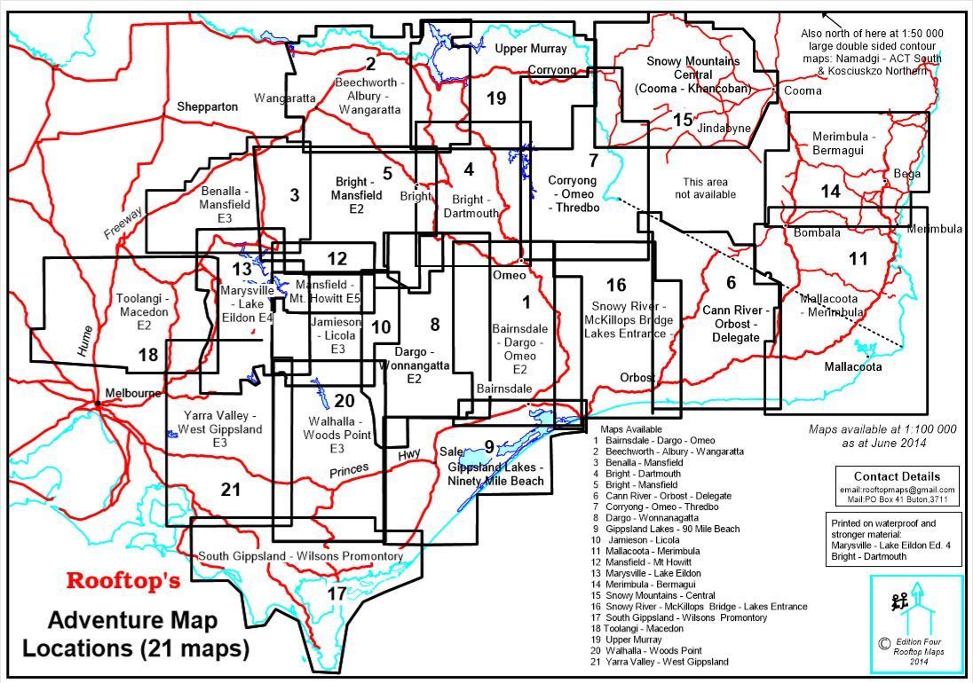
Related Items


© 2026 Mapworld. Website designed by Genie Media
X