- Australia ▾
- Topographic
▾
- Australia AUSTopo 250k (2025)
- Australia 50k Geoscience maps
- Australia 100k Geoscience maps
- Australia 250k Geoscience maps
- Australia 1:1m Geoscience maps
- New Zealand 50k maps
- New Zealand 250k maps
- New South Wales 25k maps
- New South Wales 50k maps
- New South Wales 100k maps
- Queensland 10k maps
- Queensland 25k maps
- Queensland 50k maps
- Queensland 100k maps
- Western Australia 25k maps
- Western Australia 50k maps
- Western Australia 100k maps
- Compasses
- Software
- GPS Systems
- International ▾
- Wall Maps
▾
- World
- Australia & New Zealand
- Countries, Continents & Regions
- Historical
- Vintage National Geographic
- Australian Capital Territory
- New South Wales
- Northern Territory
- Queensland
- South Australia
- Tasmania
- Victoria
- Western Australia
- Celestial
- Children's
- Mining & Resources
- Wine Maps
- Healthcare
- Postcode Maps
- Electoral Maps
- Nautical ▾
- Flags
▾
- Australian Flag Sets & Banners
- Flag Bunting
- Handwavers
- Australian National Flags
- Aboriginal Flags
- Torres Strait Islander Flags
- International Flags
- Flagpoles & Accessories
- Australian Capital Territory Flags
- New South Wales Flags
- Northern Territory Flags
- Queensland Flags
- South Australia Flags
- Tasmania Flags
- Victoria Flags
- Western Australia Flags
- Gifts ▾
- Globes ▾
Dear valued customer. Please note that our checkout is not supported by old browsers. Please use a recent browser to access all checkout capabilities


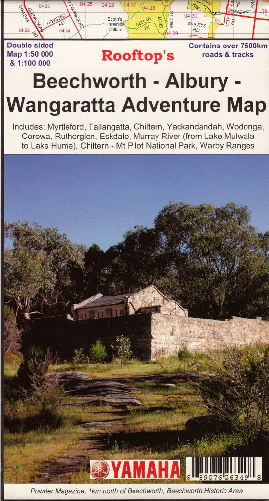
Beechworth - Albury - Wangaratta Adventure Map Rooftop
$12.95 $14.95
Afterpay is only available for orders between $50.00 and $1000.00 More info
Rooftop Maps | Topographic | Laminated Optional | 1:100,000 / 1:50,000 Scale
Whether you're planning a high country hike, a weekend of off-road exploration, or simply discovering Victoria’s northeast on foot or 4WD, the Beechworth – Albury – Wangaratta Adventure Map by Rooftop Maps is the perfect companion for serious adventurers. Meticulously field-checked and GPS-plotted, this topographic map delivers unrivalled detail of this historically rich and naturally stunning region.
🏞️ Comprehensive Regional Coverage
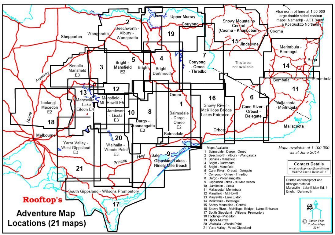
This map provides dual-scale mapping, with a 1:100,000 scale for broad regional coverage and a 1:50,000 scale enlargement on the reverse for deeper exploration.
Coverage includes:
-
North: Rutherglen, Hume Weir, Tallangatta
-
South: Wangaratta, Myrtleford, Eskdale
-
Central: Beechworth, Stanley, Chiltern, Mount Pilot, Yackandandah
Positioned centrally, Beechworth acts as your hub for navigating the surrounding alpine valleys, state forests, and highland townships.
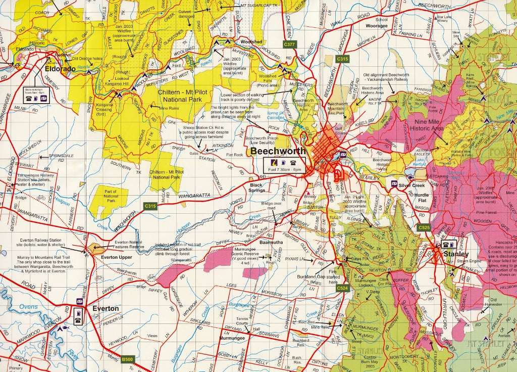
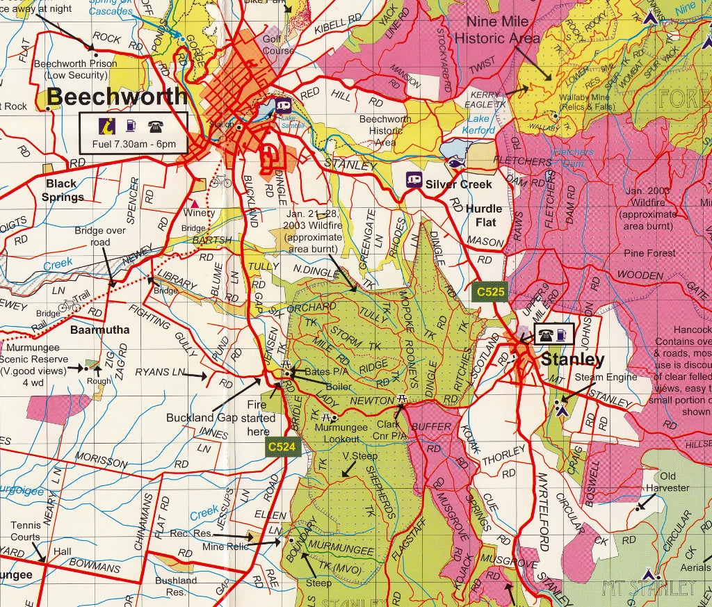
🔍 Detailed Adventure Features
Perfectly suited for bushwalkers, campers, 4WD enthusiasts, and cyclists, this map shows:
| Features Included | Details |
|---|---|
| 🛣️ Roads & Tracks | Over 7,500 km of GPS-verified roads and off-road tracks |
| 🗺️ Parks & Forests | All parks, reserves, and state forests clearly marked |
| 🏕️ Camping Areas | Bush camps, caravan parks, and picnic spots |
| 👁️ Lookouts & Scenic Points | Highlighted routes and viewpoints for panoramic photography |
| ⚠️ Safety & Info | Fire warnings, access restrictions, and updated amenity information |
| 🛶 Lakes & Rivers | Waterways, creeks, and access to Lake Hume and surrounding catchments |
The reverse map, titled "Beechworth Forest Activities Map", zooms in on the forested surrounds and heritage townships with 1:50,000 detail, ideal for navigation in more remote areas.
💼 Built for the Bush – Laminated Option Available
Choose the laminated version of this map to make trip planning interactive and field-proof:
-
Use whiteboard markers to sketch routes or update notes
-
Apply Map Dots to mark visited locations or waypoints
-
Wipe clean and reuse again and again
-
Laminated surface is tear-resistant and water-repellent, built for tough conditions
Note: Laminated versions are made from previously folded maps; minor crease lines may remain visible.
🧭 Map Specifications
| Attribute | Description |
|---|---|
| Publisher | Rooftop Maps |
| Coverage Area | Northeast Victoria, including Alpine Valleys |
| Main Scale | 1:100,000 |
| Reverse Scale | 1:50,000 (Beechworth Forest Focus) |
| Map Size | 700 mm (W) x 1000 mm (H) unfolded |
| Format | Paper or Laminated |
🌄 Why Choose Rooftop's Beechworth – Albury – Wangaratta Map?
-
Highly detailed, up-to-date topography
-
Trusted by bushwalkers, 4WD tourers, emergency services, and landcare groups
-
Produced by one of Australia’s most respected regional mapmakers
-
Packed with local insights, not just lines and roads
Explore deeper. Travel smarter. Stay safe.
With Rooftop’s Adventure Maps, you don’t just visit the landscape—you understand it.
Frequently Asked Questions
Where can I buy the Beechworth - Albury - Wangaratta Adventure Map Rooftop?
The Beechworth - Albury - Wangaratta Adventure Map Rooftop is available to buy online from Mapworld, Australia's largest map and geographic product retailer, with fast shipping Australia-wide.
Is the Beechworth - Albury - Wangaratta Adventure Map Rooftop in stock at Mapworld?
Mapworld maintains extensive stock across its map range and aims for fast dispatch. Orders placed before 2pm AEST on business days are typically dispatched the same day, with standard and express Australia-wide delivery options available.
What is Mapworld's returns policy?
Mapworld accepts returns on undamaged items in original condition. Contact Mapworld within 90 days of purchase to arrange a return or exchange.
Does Mapworld ship the Beechworth - Albury - Wangaratta Adventure Map Rooftop across Australia?
Yes, Mapworld ships Australia-wide. Standard shipping is a flat $7 rate, with free standard shipping on orders over $75. Express options are available at checkout. Most orders placed before 2pm AEST on weekdays are dispatched same day.
Related Items


© 2026 Mapworld. Website designed by Genie Media
X