- Australia ▾
- Topographic
▾
- Australia AUSTopo 250k (2025)
- Australia 50k Geoscience maps
- Australia 100k Geoscience maps
- Australia 250k Geoscience maps
- Australia 1:1m Geoscience maps
- New Zealand 50k maps
- New Zealand 250k maps
- New South Wales 25k maps
- New South Wales 50k maps
- New South Wales 100k maps
- Queensland 10k maps
- Queensland 25k maps
- Queensland 50k maps
- Queensland 100k maps
- Compasses
- Software
- GPS Systems
- Orienteering
- International ▾
- Wall Maps
▾
- World
- Australia & New Zealand
- Countries, Continents & Regions
- Historical
- Vintage National Geographic
- Australian Capital Territory
- New South Wales
- Northern Territory
- Queensland
- South Australia
- Tasmania
- Victoria
- Western Australia
- Celestial
- Children's
- Mining & Resources
- Wine Maps
- Healthcare
- Postcode Maps
- Electoral Maps
- Nautical ▾
- Flags
▾
- Australian Flag Sets & Banners
- Flag Bunting
- Handwavers
- Australian National Flags
- Aboriginal Flags
- Torres Strait Islander Flags
- International Flags
- Flagpoles & Accessories
- Australian Capital Territory Flags
- New South Wales Flags
- Northern Territory Flags
- Queensland Flags
- South Australia Flags
- Tasmania Flags
- Victoria Flags
- Western Australia Flags
- Gifts ▾
- Globes ▾
Dear valued customer. Please note that our checkout is not supported by old browsers. Please use a recent browser to access all checkout capabilities


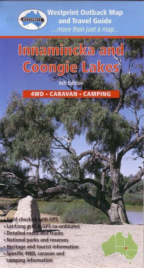
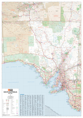
Innaminka & Coongie Lakes Map Westprint
$13.95 $15.95
Afterpay is only available for orders between $50.00 and $1000.00 More info
The Definitive Touring Map of South Australia's Remote Corner Country
Trace the footsteps of pioneers, paddle through Ramsar-listed wetlands, and drive Australia’s legendary desert tracks with this richly detailed map of Innamincka and the Coongie Lakes region. Produced by Westprint, one of Australia’s most trusted outback cartographers, this map is designed for those who crave both rugged adventure and a deeper connection with Australia's historic heartland.
Spanning a vast section of the Cooper Basin, this map brings together modern GPS-verified navigation data, ecological detail, and historical insights into one easy-to-use sheet, perfect for 4WD expeditions, overland tours, birdwatching escapes, or educational field trips.
🧭 Map Highlights & Features
-
Scale: 1:500,000 – Provides an ideal balance between regional overview and route-planning detail
-
Fully Field Checked & GPS-Compatible
-
Latitude/Longitude Grid and coordinate references throughout
-
Ideal for use with GPS units and offline navigation apps
-
✅ Road & Track Detail:
-
Clearly marked sealed, unsealed, and 4WD-only tracks
-
Includes the Strzelecki Track, routes to Cameron Corner, and lesser-known bush tracks
-
Surface types, creek crossings, and access notes for touring vehicles
🏕️ Touring, Camping & Visitor Info:
-
Campgrounds and bush camps, including Innamincka camping zones
-
Rest stops, fuel stations, picnic areas, and water points
-
Notations for caravan access and remote-friendly overnight sites
🐾 Environmental & Heritage Features:
-
The Coongie Lakes wetland complex – a UNESCO Ramsar-listed site for its biodiversity
-
Marked birdwatching zones and seasonal watercourse access points
-
Highlights of natural features such as sand dunes, gibber plains, and ephemeral creeks
📜 Historical Context:
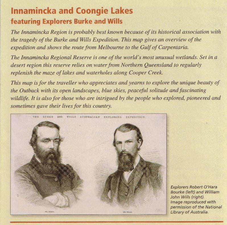
-
Detailed annotations describing Burke & Wills’ 1860–61 expedition, one of Australia’s most significant exploration journeys
-
Shows Camp 65, Dig Tree locations, and explorer routes
-
Includes brief narratives outlining key moments of their fateful journey
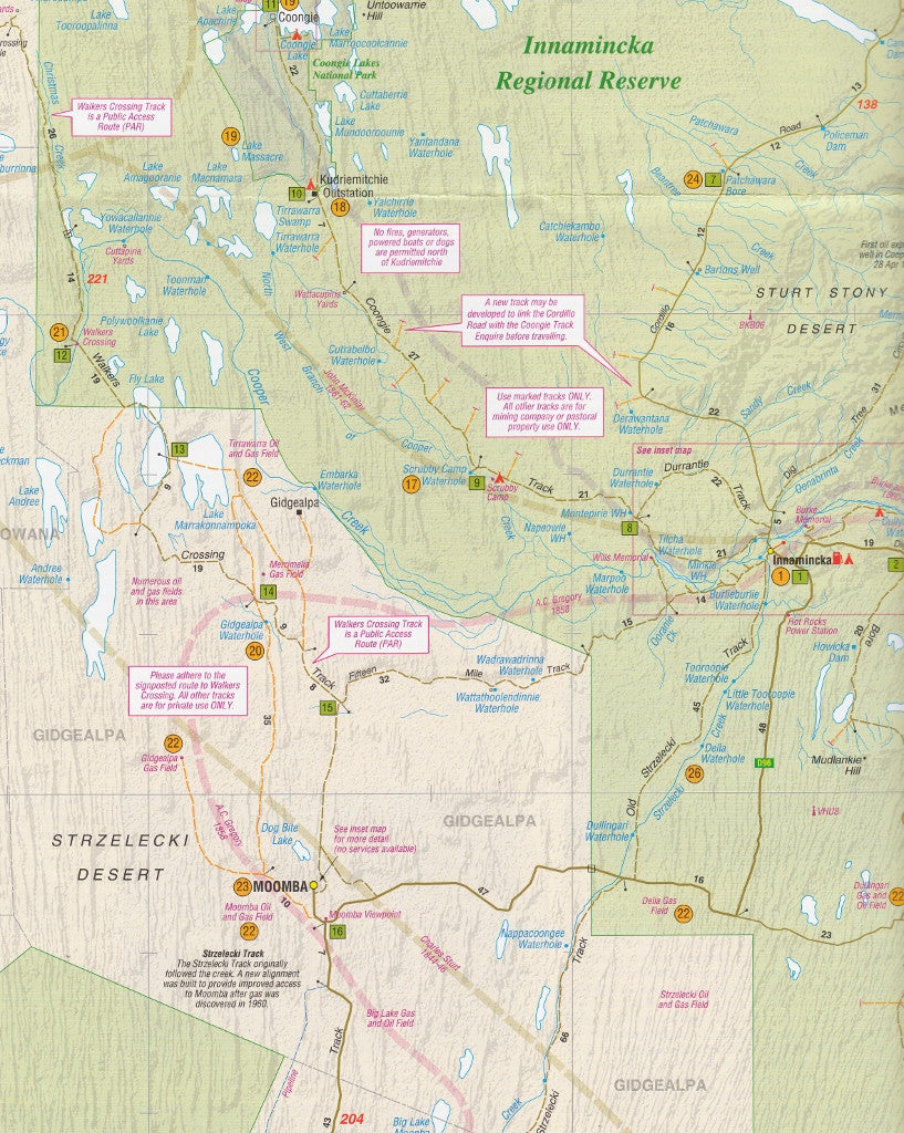
📍 Area Coverage Includes:
-
Innamincka Regional Reserve
-
Coongie Lakes and associated wetland systems
-
Birdsville Track (southern section)
-
Cameron Corner (NSW, QLD, SA border convergence)
-
Routes toward Cooper Creek, Strzelecki Desert, Cordillo Downs, and Moomba
-
Parts of the South Australian Channel Country and the outer edges of Sturt Stony Desert
📘 Why This Map Stands Out:
| Feature | Benefit |
|---|---|
| 🔍 Detailed 1:500,000 scale | Perfect for both macro trip planning and micro-navigation |
| 🛰️ Field-tested with GPS | Accurate and reliable in the most remote locations |
| 📚 Historical notes included | Adds depth and context to your travels |
| 🧭 Tourism-ready navigation | Includes all major services, facilities, and route tips |
| 🧳 Outback travel-specific info | Fuel range, water sources, and access notes included |
| 💧 Laminated Option Available | Durable, waterproof, and writeable—ideal for vehicles and field use |
📐 Map Specifications:
| Specification | Details |
|---|---|
| Publisher | Westprint Heritage Maps |
| Edition | Latest Edition |
| Scale | 1:500,000 |
| Size | 700 mm x 1000 mm |
| Format | Flat, single-sided |
| Material | Paper or optional laminated version |
🧱 Optional Lamination Upgrade
We offer this map laminated between two sheets of high-quality 80-micron gloss film, making it:
-
💧 Waterproof and tear-resistant
-
✏️ Writable with whiteboard or permanent markers
-
🗺️ Perfect for re-use in trip planning, classroom displays, or vehicle dashboards
Please note: slight fold lines may remain visible on laminated versions due to original folding.
🎯 Perfect For:
-
🚙 4WD adventurers exploring the Strzelecki Desert or Cooper Creek
-
🏕️ Outback travellers seeking campgrounds, tracks, and route advice
-
📸 Nature photographers visiting the Coongie wetland system
-
📖 History lovers tracing the steps of Burke & Wills
-
📚 Schools & educational groups studying Australian inland exploration
-
🌏 Ecotourists & birdwatchers tracking migratory species in Ramsar habitats
-
🛻 Caravaners and Grey Nomads on extended overland tours
🌄 Innamincka & Coongie Lakes: Where History Meets Wilderness
This map does more than guide you—it tells the stories of a place where the deserts pulse with life, wetlands flourish in the arid interior, and Australia’s most famous explorers left their mark. Whether you’re following Cooper Creek to its far reaches or camping beside ancient river red gums, this is the map that brings the experience to life.
Plan your route. Understand the land. Travel with Westprint.
Add the Innamincka & Coongie Lakes Map to your travel kit today and navigate one of Australia’s most compelling outback regions with confidence and curiosity.
Frequently Asked Questions
What does the Innaminka & Coongie Lakes Map Westprint cover?
The Innaminka & Coongie Lakes Map Westprint covers 4WD tracks, camping areas, and travel routes for the region described in the product title. Most 4WD and camping guides in Mapworld's range include GPS coordinates, distance information, difficulty ratings, and notes on fuel stops and emergency contact points.
Is the Innaminka & Coongie Lakes Map Westprint up to date?
Yes, this is the current edition. Mapworld stocks current editions from publishers including Hema Maps, Westprint, and others.
Is this product suitable for remote area travel?
Yes, 4WD maps and guides are designed for remote area navigation and trip planning. They include track conditions, fuel availability, camping spots, and safety information.
Does Mapworld ship the Innaminka & Coongie Lakes Map Westprint across Australia?
Yes, Mapworld ships Australia-wide. Standard shipping is a flat $7 rate, with free standard shipping on orders over $75. Express options are available at checkout. Most orders placed before 2pm AEST on weekdays are dispatched same day.
Related Items


© 2026 Mapworld. Website designed by Genie Media
X