- Australia ▾
- Topographic
▾
- Australia AUSTopo 250k (2025)
- Australia 50k Geoscience maps
- Australia 100k Geoscience maps
- Australia 250k Geoscience maps
- Australia 1:1m Geoscience maps
- New Zealand 50k maps
- New Zealand 250k maps
- New South Wales 25k maps
- New South Wales 50k maps
- New South Wales 100k maps
- Queensland 10k maps
- Queensland 25k maps
- Queensland 50k maps
- Queensland 100k maps
- Compasses
- Software
- GPS Systems
- Orienteering
- International ▾
- Wall Maps
▾
- World
- Australia & New Zealand
- Countries, Continents & Regions
- Historical
- Vintage National Geographic
- Australian Capital Territory
- New South Wales
- Northern Territory
- Queensland
- South Australia
- Tasmania
- Victoria
- Western Australia
- Celestial
- Children's
- Mining & Resources
- Wine Maps
- Healthcare
- Postcode Maps
- Electoral Maps
- Nautical ▾
- Flags
▾
- Australian Flag Sets & Banners
- Flag Bunting
- Handwavers
- Australian National Flags
- Aboriginal Flags
- Torres Strait Islander Flags
- International Flags
- Flagpoles & Accessories
- Australian Capital Territory Flags
- New South Wales Flags
- Northern Territory Flags
- Queensland Flags
- South Australia Flags
- Tasmania Flags
- Victoria Flags
- Western Australia Flags
- Gifts ▾
- Globes ▾
Dear valued customer. Please note that our checkout is not supported by old browsers. Please use a recent browser to access all checkout capabilities


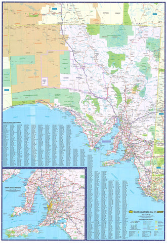
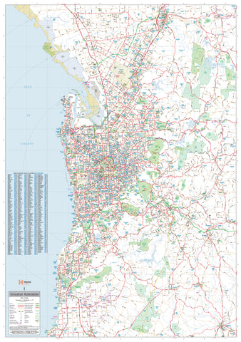
South Australia Hema 700 x 1000mm Laminated Wall Map
$99.00
or make 4 interest-free payments of
$24.75 AUD
fortnightly with
![]() More info
More info
Double-Laminated | Write-On Surface | Fade-Resistant Ink | Made in Australia 🇦🇺
From the vivid ochres of the Flinders Ranges to the turquoise edges of the Eyre Peninsula, South Australia is a land of sweeping contrasts — wild, elegant, and often underappreciated. This Hema Laminated Wall Map brings that expanse into sharp focus, presenting every detail with clarity, colour, and care.
Created by Australia’s most trusted mapmaker, this large-format map offers comprehensive state-wide coverage while remaining easy to read and beautiful to display. It’s as much a practical navigation tool as it is a celebration of place — equally suited to business walls, caravans, classrooms, and home offices.
A Cartographic Overview Like No Other
This map presents an all-in-one view of South Australia, drawing together thousands of data points into one seamless visual experience. It balances macro-level topography with micro-level navigational detail.
You’ll find:
-
🏙️ All towns and cities – From major centres like Adelaide, Port Lincoln, and Mount Gambier, to remote outposts such as Coober Pedy, Oodnadatta, and Innamincka
-
🛣️ Highways, sealed and unsealed roads – Including the Stuart, Princes, and Eyre Highways, plus iconic inland routes
-
🏞️ National parks and reserves – From the Flinders Ranges to the Nullarbor’s vast edges
-
🏕️ Remote tracks – Including the Oodnadatta Track, Birdsville Track, and Strzelecki Track, favoured by serious off-road adventurers
-
🧭 Coastal regions – Clearly detailed mapping of Yorke Peninsula, Eyre Peninsula, and Kangaroo Island
-
🏖️ Natural features – Lakes, rivers, mountains, salt flats, and deserts, with terrain accurately rendered
This map is designed not just to inform but to inspire — a visual feast for anyone curious about the state’s natural grandeur and rural depth.
🖊️Built for Function – Laminated & Writable
This is more than a paper map. It’s a professional-grade, double-laminated wall map, created to stand up to daily use.
✅ Write-on, wipe-off surface – Use whiteboard markers to plan trips, highlight regions, or add notes
✅ Compatible with Mark-It Dots – Ideal for showing business locations, travel routes, or points of interest
✅ Water-resistant, tear-resistant, stain-resistant – Made to survive offices, classrooms, campervans, and dusty roadside cafes
✅ Gloss-laminated with a smooth, professional finish – Makes colours pop and detail crisp
The base map is printed on 120 gsm FSC-certified coated paper using pigment-based, fade-resistant inks by Hewlett-Packard — an assurance of both ecological responsibility and long-term clarity. It is then fully encapsulated in two layers of 80-micron gloss laminate, protecting it for years of pinning, handling, drawing, and display.
Flat Laminated Map – $99.00 (Premium Edition)
Perfect for framing, pinning, or wall-hanging. This map is professionally laminated without folds, offering a completely smooth, uncreased surface — ideal for display in a home office, workplace, or meeting space.
📏 Product Specifications
| Feature | Detail |
|---|---|
| Map Dimensions | 700 mm (width) x 1000 mm (height) |
| Scale | 1:1,800,000 |
| Format | Laminated wall map – available flat or folded |
| Material | 120 gsm FSC-coated paper, encapsulated in 80-micron gloss laminate |
| Print Quality | Pigment-based fade-resistant inks (HP) |
| Writable Surface | Yes – compatible with whiteboard markers and map dots |
| Publisher | Hema Maps – Australia’s trusted name in mapping |
| Made In | Australia 🇦🇺 |
Who This Map is For
Homeowners & Enthusiasts
Hang it in your study, hallway, or kitchen to admire the natural sweep of South Australia. Pin your road trips. Plan your next long weekend. Dream big.
Grey Nomads, Vanlifers & 4WD Explorers
Use it to plot your course through the outback. Mark campsites, fuel stops, remote stations, and hidden waterholes. The perfect wall companion to your Hema atlas or GPS.
Business Operators & Regional Managers
Ideal for real estate offices, agricultural operators, logistics teams, and anyone managing clients or assets across the state. Visualise delivery zones, service areas, and market regions.
Educators & Students
A rich teaching tool for geography, social studies, environmental science, and more. Big enough to show clear detail to a whole class.
Tourism & Hospitality Professionals
Use it in guesthouses, tourism centres, or wineries to help visitors understand the regional layout. It invites conversation and planning.
Why Choose Hema?
With over 40 years of fieldwork, cartographic excellence, and publishing experience, Hema Maps is the gold standard in Australian mapping. Known for their accuracy, attention to detail, and rugged usability, Hema products are trusted by:
-
4WD tour leaders
-
Teachers and schools
-
Remote service providers
-
Explorers, campers, and caravanners
-
Australian government and tourism bodies
Their maps are not only designed in Australia — they’re made for Australia.
📦 What’s Included:
-
🗺️ 1 x Laminated South Australia Wall Map (choose flat or folded)
-
📜 Protective packaging for safe shipping – rolled for flat maps, folded for economy option
Ready to Explore South Australia?
From Adelaide’s city lights to the silent dunes of the Simpson Desert, this map gives you a complete visual overview of South Australia — its roads, its towns, and its wild empty spaces. It’s a practical tool, a planning aid, and a celebration of one of Australia’s most distinct and diverse regions.
Add it to your wall. Add it to your cart.
And start mapping your journey today.
Frequently Asked Questions
What are the dimensions of the South Australia Hema 700 x 1000mm Laminated Wall Map?
Mapworld wall maps range from standard 700×1000mm to large-format 1000×1430mm Supermaps. The exact dimensions for this map are shown in the product title. Where multiple sizes are available, select your preferred size when adding to cart.
Is this wall map available laminated?
Many Mapworld wall maps are available in paper, laminated, or framed finishes. Check the product options when adding to cart. Laminated maps are wipe-clean and more durable.
Is this the latest edition?
Mapworld stocks the most current editions available from all publishers. Edition year is shown in the product title where applicable. Mapworld updates its catalogue as new editions are released.
Can I write on or pin this wall map?
Laminated wall maps can be written on with whiteboard markers and wiped clean. Paper maps can be pinned on a corkboard. Choose a laminated option for a writeable surface.
Does Mapworld ship the South Australia Hema 700 x 1000mm Laminated Wall Map across Australia?
Yes, Mapworld ships Australia-wide. Standard shipping is a flat $7 rate, with free standard shipping on orders over $75. Express options are available at checkout. Most orders placed before 2pm AEST on weekdays are dispatched same day.
Related Items


© 2026 Mapworld. Website designed by Genie Media
X