- Australia ▾
- Topographic
▾
- Australia AUSTopo 250k (2025)
- Australia 50k Geoscience maps
- Australia 100k Geoscience maps
- Australia 250k Geoscience maps
- Australia 1:1m Geoscience maps
- New Zealand 50k maps
- New Zealand 250k maps
- New South Wales 25k maps
- New South Wales 50k maps
- New South Wales 100k maps
- Queensland 10k maps
- Queensland 25k maps
- Queensland 50k maps
- Queensland 100k maps
- Compasses
- Software
- GPS Systems
- Orienteering
- International ▾
- Wall Maps
▾
- World
- Australia & New Zealand
- Countries, Continents & Regions
- Historical
- Vintage National Geographic
- Australian Capital Territory
- New South Wales
- Northern Territory
- Queensland
- South Australia
- Tasmania
- Victoria
- Western Australia
- Celestial
- Children's
- Mining & Resources
- Wine Maps
- Healthcare
- Postcode Maps
- Electoral Maps
- Nautical ▾
- Flags
▾
- Australian Flag Sets & Banners
- Flag Bunting
- Handwavers
- Australian National Flags
- Aboriginal Flags
- Torres Strait Islander Flags
- International Flags
- Flagpoles & Accessories
- Australian Capital Territory Flags
- New South Wales Flags
- Northern Territory Flags
- Queensland Flags
- South Australia Flags
- Tasmania Flags
- Victoria Flags
- Western Australia Flags
- Gifts ▾
- Globes ▾
Dear valued customer. Please note that our checkout is not supported by old browsers. Please use a recent browser to access all checkout capabilities


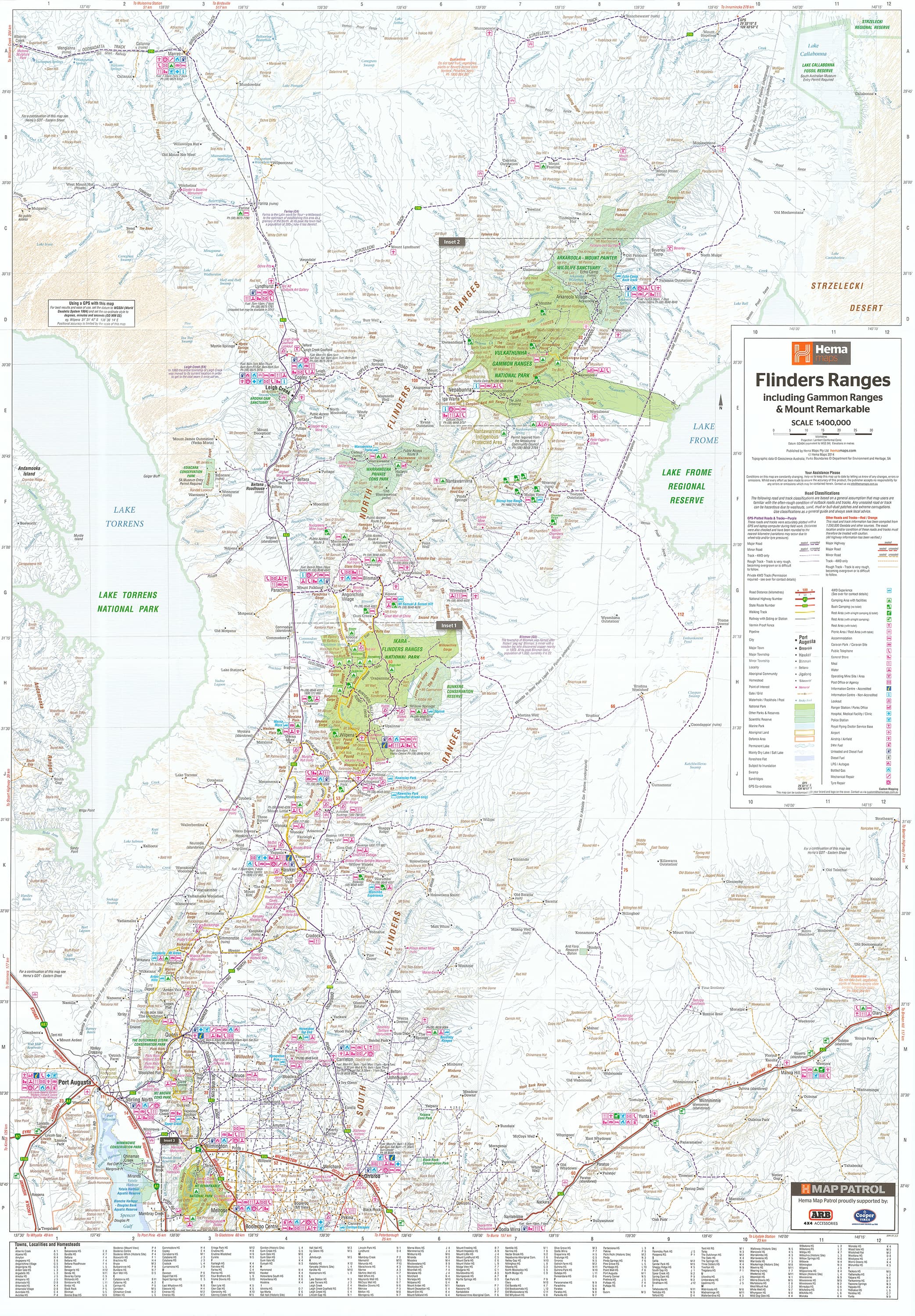

Flinders Ranges Hema Map 700 x 1000mm Laminated Wall Map
$49.95
Afterpay is only available for orders between $50.00 and $1000.00 More info
Scale: 1:400,000 | Size: 700 mm (W) x 1000 mm (H) | Encapsulated in 80-Micron Gloss Laminate
A rugged, reliable, and beautifully detailed wall map of South Australia's most iconic outback destination — made to guide, inspire, and endure.
🌄 Explore One of Australia’s Great Landscapes — In Full Detail
The Flinders Ranges, with its dramatic ridges, ancient gorges, and red rock escarpments, is one of the most visually stunning and culturally significant landscapes in the country. Whether you're crossing rugged 4WD tracks, bushwalking through remote ranges, or following the footsteps of the Adnyamathanha people, this expertly crafted wall map by Hema provides everything you need to understand, plan, and experience the region.
Laminated for durability and updated with GPS-surveyed data, this map is not only a functional navigation tool, but also a striking display piece for homes, off-grid cabins, offices, education centres, and 4WD setups.
Map Features at a Glance
| Feature | Why It Matters |
|---|---|
| 1:400,000 Scale Mapping | Ideal for showing fine detail while still covering the broader region |
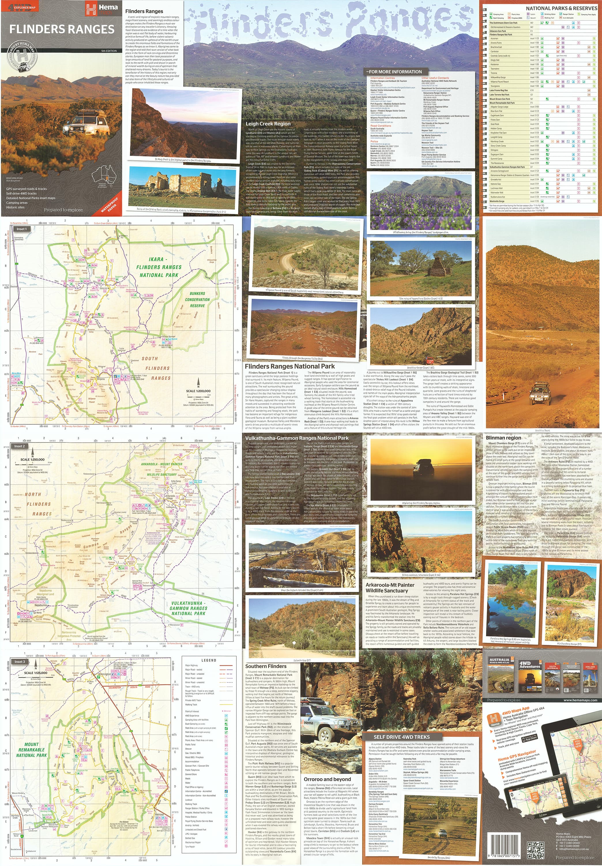
| Inset Maps of 3 Major National Parks | Includes Flinders Ranges NP, Vulkathunha-Gammon Ranges NP, and Mount Remarkable NP |
| Self-Drive 4WD Tracks | Accurately marked for safe and adventurous off-road touring |
| Walking Trails | Showcased for day hikes or longer treks across scenic ridgelines and gorges |
| Campsites & Bush Camping Areas | Clearly marked for trip planning, overnight stops, and remote exploration |
| Historic Sites & Cultural Markers | Includes ruins, Aboriginal sites, heritage settlements, and old mining tracks |
| Waterholes, Lookouts, and Gorges | Natural features highlighted for sightseeing, swimming, and photography |
| GPS-Surveyed Roads & Tracks | Real-world data ensures up-to-date accuracy for field navigation |
| Fully Laminated (Encapsulated) | Waterproof, tear-resistant, and compatible with whiteboard markers |
🗺️ What's On the Map?
-
Flinders Ranges National Park: Iconic sites like Wilpena Pound, Bunyeroo and Brachina Gorges, Arkaroo Rock, and more
-
Vulkathunha-Gammon Ranges National Park: Remote, rugged terrain perfect for seasoned hikers and outback explorers
-
Mount Remarkable National Park: A lush, highland contrast to the red dust of the north, with popular trails and picnic areas
-
Tracks and Trails: From well-known 4WD loops to remote access roads and lesser-known walking paths
-
Touring Essentials: Fuel stops, lookout points, sealed and unsealed roads, and major landmarks
-
Topography: Elevation changes and landscape features give insight into the terrain and trail difficulty
🛡️ Why Laminated?
This map has been professionally flattened and encapsulated in 80-micron gloss laminate, making it:
-
✏️ Writable & Reusable: Use whiteboard markers to plot trips, make notes, or highlight favourite spots
-
💧 Waterproof & Dustproof: Perfect for use in the field, on the bonnet of your 4WD, or in dusty conditions
-
💪 Tear-Resistant: A hard-wearing choice for regular use, route planning, and long-term display
-
📌 Ideal for pinboards or map dots — great for showing visited or planned locations
Note: Because this map is laminated from a previously folded version, very light crease lines may still be visible beneath the laminate.
📐 Product Specifications
| Detail | Description |
|---|---|
| Map Title | Flinders Ranges Laminated Wall Map |
| Publisher | Hema Maps, Australia |
| Map Series | Hema Touring & 4WD Regional Series |
| Scale | 1:400,000 |
| Map Size | 700 mm (W) x 1000 mm (H) |
| Finish | Gloss laminated (80 micron, double-sided) |
| Format | Flat wall map (not folded) |
| Inset Maps | Flinders Ranges NP, Gammon Ranges NP, Mt Remarkable NP |
| Road Data | GPS-surveyed, graded by type |
| Edition | Latest available |
🎯 Who Is This Map For?
-
🚙 4WD Adventurers plotting multi-day self-drive expeditions
-
🏕️ Campers and Caravaners looking for reliable planning tools
-
🧭 Hikers and Trail Walkers exploring iconic ridgelines and gorges
-
🧑🏫 Educators and Interpretation Centres needing a clear regional reference
-
🏡 Decorators and map lovers seeking a striking, meaningful piece for wall display
-
🎁 Gift buyers shopping for an outback enthusiast or explorer
🧭 Why the Flinders?
Located north of Adelaide and stretching for over 400 km, the Flinders Ranges are one of Australia’s great natural treasures — a place where geology, Aboriginal history, remote travel, and rugged beauty all converge. This map helps you unlock its secrets — and ensures you don’t miss a thing.
Adventure-ready. Display-worthy. Built to last.
The Flinders Ranges Hema Laminated Wall Map is the perfect companion — before, during, and after your journey.
Frequently Asked Questions
What are the dimensions of the Flinders Ranges Hema Map 700 x 1000mm Laminated Wall Map?
Mapworld wall maps range from standard 700×1000mm to large-format 1000×1430mm Supermaps. The exact dimensions for this map are shown in the product title. Where multiple sizes are available, select your preferred size when adding to cart.
Is this wall map available laminated?
Many Mapworld wall maps are available in paper, laminated, or framed finishes. Check the product options when adding to cart. Laminated maps are wipe-clean and more durable.
Is this the latest edition?
Mapworld stocks the most current editions available from all publishers. Edition year is shown in the product title where applicable. Mapworld updates its catalogue as new editions are released.
Can I write on or pin this wall map?
Laminated wall maps can be written on with whiteboard markers and wiped clean. Paper maps can be pinned on a corkboard. Choose a laminated option for a writeable surface.
Does Mapworld ship the Flinders Ranges Hema Map 700 x 1000mm Laminated Wall Map across Australia?
Yes, Mapworld ships Australia-wide. Standard shipping is a flat $7 rate, with free standard shipping on orders over $75. Express options are available at checkout. Most orders placed before 2pm AEST on weekdays are dispatched same day.
Related Items


© 2026 Mapworld. Website designed by Genie Media
X