- Australia ▾
- Topographic
▾
- Australia AUSTopo 250k (2025)
- Australia 50k Geoscience maps
- Australia 100k Geoscience maps
- Australia 250k Geoscience maps
- Australia 1:1m Geoscience maps
- New Zealand 50k maps
- New Zealand 250k maps
- New South Wales 25k maps
- New South Wales 50k maps
- New South Wales 100k maps
- Queensland 10k maps
- Queensland 25k maps
- Queensland 50k maps
- Queensland 100k maps
- Compasses
- Software
- GPS Systems
- Orienteering
- International ▾
- Wall Maps
▾
- World
- Australia & New Zealand
- Countries, Continents & Regions
- Historical
- Vintage National Geographic
- Australian Capital Territory
- New South Wales
- Northern Territory
- Queensland
- South Australia
- Tasmania
- Victoria
- Western Australia
- Celestial
- Children's
- Mining & Resources
- Wine Maps
- Healthcare
- Postcode Maps
- Electoral Maps
- Nautical ▾
- Flags
▾
- Australian Flag Sets & Banners
- Flag Bunting
- Handwavers
- Australian National Flags
- Aboriginal Flags
- Torres Strait Islander Flags
- International Flags
- Flagpoles & Accessories
- Australian Capital Territory Flags
- New South Wales Flags
- Northern Territory Flags
- Queensland Flags
- South Australia Flags
- Tasmania Flags
- Victoria Flags
- Western Australia Flags
- Gifts ▾
- Globes ▾
Dear valued customer. Please note that our checkout is not supported by old browsers. Please use a recent browser to access all checkout capabilities


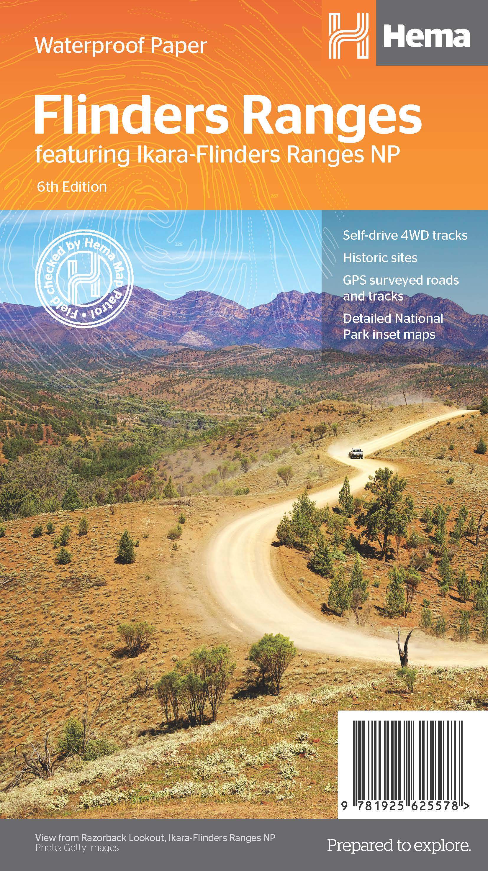
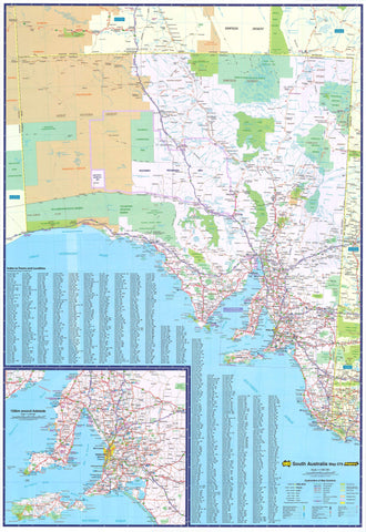
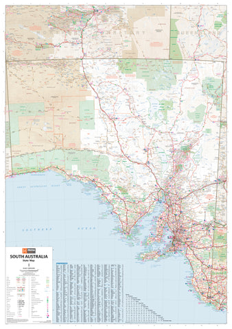
Flinders Ranges Hema Map 6th Edition
$14.95 $15.95
Afterpay is only available for orders between $50.00 and $1000.00 More info
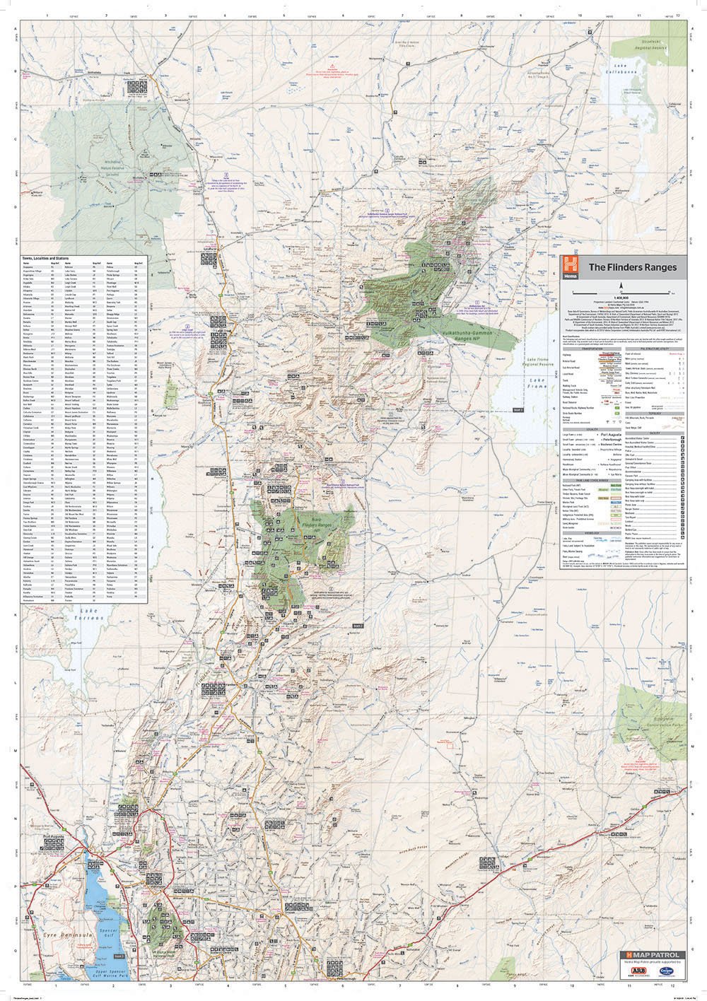
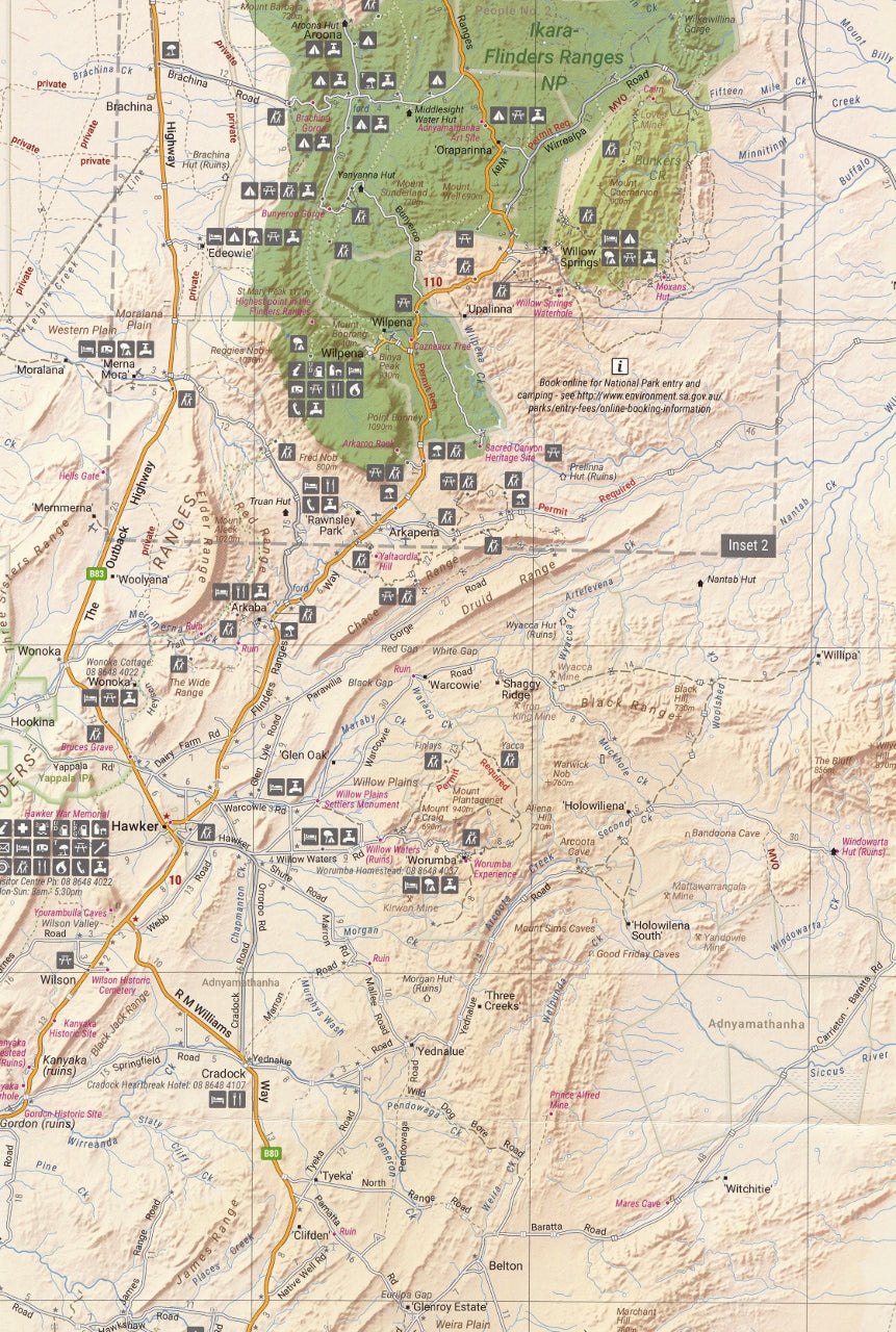
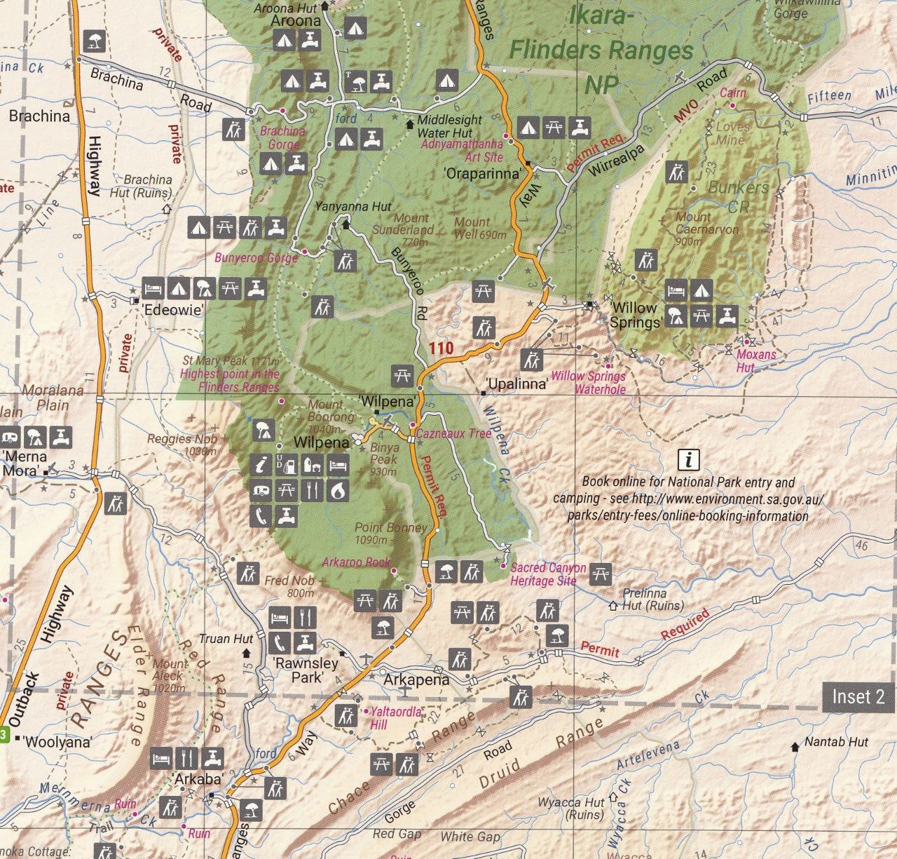
A comprehensive, field-verified touring and 4WD map for navigating South Australia's rugged outback treasure
The Flinders Ranges are among Australia’s most iconic and geologically dramatic landscapes, stretching over 400 km through the South Australian outback. From the towering peaks of Wilpena Pound (Ikara) to the remote reaches of the Gammon Ranges, this vast, ancient region is steeped in both natural beauty and Aboriginal cultural significance. Whether you're navigating its winding tracks, discovering fossil beds, or camping under the clearest night skies, the Hema Flinders Ranges Map (6th Edition) is your essential navigation and planning tool.
Meticulously updated and field-checked by Hema’s Map Patrol, this map combines topographic accuracy, off-road detail, and cultural insight in a highly durable format. It’s perfect for 4WD adventurers, hikers, campers, and anyone looking to fully experience this remarkable part of South Australia.
🗺️ Map Specifications:
-
Scale: 1:400,000 (1 cm = 4 km) – suitable for both trip planning and in-vehicle use
-
Flat Size: 1000 mm (H) x 700 mm (W)
-
Folded Size: 250 mm x 140 mm
-
Weight: Approx. 90 grams
-
Edition: 6th
-
Published: 1 November 2018
-
Printed On: Waterproof and tear-resistant synthetic paper for maximum durability in the field
🧭 Key Features:
🚙 Touring & 4WD Navigation:
-
All roads and tracks GPS-surveyed by the Hema Map Patrol
-
Includes sealed roads, unsealed roads, and 4WD-only tracks
-
Highlighted self-drive 4WD routes and touring loops
-
Annotated with distances, points of difficulty, and key waypoints
-
Excellent resource for off-road adventurers, tag-along tours, and remote travellers
🏕️ Camping, Hiking & Outdoors:
-
Clearly marked campgrounds, bush camps, and picnic areas
-
Walking trails and bushwalking routes throughout the Flinders and Gammon Ranges
-
Water sources, lookouts, and firewood collection zones shown
-
Includes location markers for shelters, huts, and scenic highlights
🗺️ Inset Maps:
-
Ikara–Flinders Ranges National Park – showing walking trails, access points, and cultural features
-
Vulkathunha–Gammon Ranges National Park – detailing trails, remote camps, and 4WD routes
-
Insets offer extra clarity and zoomed-in terrain awareness for complex sections of the region
🪧 Cultural and Historical Insight:
-
Locations of Aboriginal sites, ruins, and early settlements
-
Interpretation panels explaining the history, geology, and traditions of the Adnyamathanha people, the Traditional Owners of the region
-
Notes on fossil sites, bluff formations, and station heritage
🛠️ Useful Travel Information:
-
Icons for fuel stops, stations, roadhouses, and key resupply points
-
Emergency contacts, ranger stations, and park info centres
-
Seasonal notes on track closures and weather conditions
-
Land tenure information, including pastoral leases, national parks, and Aboriginal lands
🚗 Who Should Use This Map?
-
4WD explorers tackling the Brachina and Parachilna Gorge drives
-
Bushwalkers planning day hikes or multi-day trekking routes in the Gammon Ranges
-
Campers and vanlifers seeking quiet outback bush camps and caravan-friendly sites
-
Photographers and artists searching for dramatic outback scenery
-
Ecotourists and geology buffs interested in the fossil-rich landscapes and ancient seabeds
-
Educators, tour operators, and nature guides providing context to the land and its people
💡 Additional Recommendation:
Pair the map with the Hema Flinders Ranges: An Adventurer's Guide — a 4WD and travel guidebook packed with track notes, history, and travel tips — for a deeper understanding of the region.
✅ Why Choose Hema’s Flinders Ranges Map?
-
More than a map — it’s a full visual guide to South Australia’s greatest outback landscape
-
Created by Australia’s most trusted cartographers and field explorers
-
Weatherproof, foldable, and made to survive the rigours of real-world travel
-
Fully compatible with GPS navigation tools and online route planning
Whether you're driving the ridgelines at sunset, soaking in the solitude of a gorge campsite, or simply tracing the ancient story of the land beneath your wheels, the Hema Flinders Ranges Map helps you explore smarter, safer, and deeper.
Adventure north. Explore wild. Travel with Hema — and discover the true spirit of the Flinders.
This map is also available as a laminated map encapsulated in high-quality plastic.
Frequently Asked Questions
What does the Flinders Ranges Hema Map 6th Edition cover?
The Flinders Ranges Hema Map 6th Edition covers 4WD tracks, camping areas, and travel routes for the region described in the product title. Most 4WD and camping guides in Mapworld's range include GPS coordinates, distance information, difficulty ratings, and notes on fuel stops and emergency contact points.
Is the Flinders Ranges Hema Map 6th Edition up to date?
Yes, this is the current edition. Mapworld stocks current editions from publishers including Hema Maps, Westprint, and others.
Is this product suitable for remote area travel?
Yes, 4WD maps and guides are designed for remote area navigation and trip planning. They include track conditions, fuel availability, camping spots, and safety information.
Does Mapworld ship the Flinders Ranges Hema Map 6th Edition across Australia?
Yes, Mapworld ships Australia-wide. Standard shipping is a flat $7 rate, with free standard shipping on orders over $75. Express options are available at checkout. Most orders placed before 2pm AEST on weekdays are dispatched same day.
Related Items


© 2026 Mapworld. Website designed by Genie Media
X