AUS 778 — Point Riley to Port Augusta, SA Nautical Chart
For skippers, pilots, and coastal crews running the Point Riley–Port Augusta sector
Run confident coastal tracks with AUS 778. The main sheet delivers Spencer Gulf’s upper reaches at 1:150,000 on Mercator projection—ideal for route shaping, landfall bearings and waypoint checks—supported by close-quarters Port Augusta approach and harbour subcharts on UTM/Transverse Mercator.
Why skippers choose this chart
-
🧭 Built for coastal runs & approaches — Main sheet at 1:150,000 plus detailed approach/wharf panels.
-
🚢 Traffic & approach awareness — Subcharts aid final legs and alongside manoeuvres into Port Augusta.
-
🛰️ Mercator + UTM panels — Straightforward coastal bearings; crisp close-in GPS plotting on approach.
-
📍 Exact bounds — All four limits listed for quick position checks (see below).
-
🗺️ Deck-ready materials — Writeable laminate front face for chart-correction pencils.
-
🇦🇺 Printed in Australia — Colour-managed, hand-checked.
Coverage
-
Main Chart — AUS 778: Australia South Coast · South Australia · Point Riley to Port Augusta
-
Scale: 1:150,000 · Projection: Mercator
-
Bounds: N 32°29.01′ S · S 33°54.51′ S · E 138°04.65′ E · W 137°05.28′ E
-
Publication: 01-Feb-1978 · Latest Edition: 26-Jul-2019
-
-
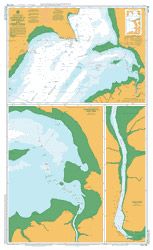
Subchart — AUS 778/1: Approaches to Port Augusta
-
Scale: 1:25,000 · Projection: Universal Transverse Mercator
-
Bounds: N 32°29.31′ S · S 32°39.28′ S · E 137°47.43′ E · W 137°44.88′ E
-
Publication: 01-Feb-1978 · Latest Edition: 26-Jul-2019
-
-
Subchart — AUS 778/2: Port Augusta (Wharf area)
-
Scale: 1:7,500 · Projection: Universal Transverse Mercator
-
Bounds: N 32°29.11′ S · S 32°29.91′ S · E 137°45.88′ E · W 137°45.08′ E
-
Publication: 01-Feb-1978 · Latest Edition: 26-Jul-2019
-
-
Subchart — AUS 778/3: Lucky Bay
-
Scale: 1:10,000 · Projection: Transverse Mercator
-
Bounds: N 33°42.30′ S · S 33°43.08′ S · E 137°03.00′ E · W 137°02.03′ E
-
Publication: 15-Nov-1977 · Latest Edition: 26-Jul-2019
-
Premium materials & finishes
-
Paper (120 gsm matte) — Crisp, flexible and chart-table friendly; ideal under nav-station glass.
-
Laminated (soft-matte front / gloss back, edge-sealed) — Front side is low-glare and writeable with chart-correcting/grease pencils; gloss back adds rigidity. Wipes clean with a soft cloth.
Note: We’ve intentionally configured the laminate with a soft-matte writeable face and a gloss reverse so you can annotate pilotage notes, fixes and ETAs directly on the chart, then clean down between passages.
On-board & ashore use
-
🧭 Passage planning — Pre-plot coastal tracks, tide gates and contingencies.
-
📒 Crew briefings — Clear layout for marks, leads and waypoint verification.
-
🛠️ Bridge/club display — Durable laminated option for noticeboards and training rooms.
-
🎁 Gift for skippers — A practical, good-looking chart for SA crews.
Specifications
| Field | Detail |
|---|---|
| Chart Number | AUS 778 |
| Title | Australia South Coast — South Australia — Point Riley to Port Augusta |
| Geographic Location | Australia |
| Scale (main) | 1:150,000 |
| Projection | Mercator (main); Universal Transverse Mercator & Transverse Mercator (subcharts) |
| North / South Limits | 32°29.01′ S / 33°54.51′ S |
| East / West Limits | 138°04.65′ E / 137°05.28′ E |
| Publication Date | 01-Feb-1978 |
| Latest Edition | 26-Jul-2019 |
| Sheet Size | 1100 mm (W) × 770 mm (H) |
| Available Finishes | Paper (120 gsm matte); Laminated (soft-matte writeable front, gloss back, edge-sealed) |
| Inks | Pigment-based, fade-resistant |
| Origin | Printed in Australia |
Important note (mariner’s guidance)
This product is ideal for planning, briefing, education, and display. For underway navigation, always carry and consult the latest official hydrographic chart or approved ECDIS and current Notices to Mariners. Local conditions and aids may change.
Ready to run Point Riley to Port Augusta?
Select your finish above and add to cart. We’ll print locally, hand-check, and ship with care.