- Australia ▾
- Topographic
▾
- Australia AUSTopo 250k (2025)
- Australia 50k Geoscience maps
- Australia 100k Geoscience maps
- Australia 250k Geoscience maps
- Australia 1:1m Geoscience maps
- New Zealand 50k maps
- New Zealand 250k maps
- New South Wales 25k maps
- New South Wales 50k maps
- New South Wales 100k maps
- Queensland 10k maps
- Queensland 25k maps
- Queensland 50k maps
- Queensland 100k maps
- Western Australia 25k maps
- Western Australia 50k maps
- Western Australia 100k maps
- Compasses
- Software
- GPS Systems
- International ▾
- Wall Maps
▾
- World
- Australia & New Zealand
- Countries, Continents & Regions
- Historical
- Vintage National Geographic
- Australian Capital Territory
- New South Wales
- Northern Territory
- Queensland
- South Australia
- Tasmania
- Victoria
- Western Australia
- Celestial
- Children's
- Mining & Resources
- Wine Maps
- Healthcare
- Postcode Maps
- Electoral Maps
- Nautical ▾
- Flags
▾
- Australian Flag Sets & Banners
- Flag Bunting
- Handwavers
- Australian National Flags
- Aboriginal Flags
- Torres Strait Islander Flags
- International Flags
- Flagpoles & Accessories
- Australian Capital Territory Flags
- New South Wales Flags
- Northern Territory Flags
- Queensland Flags
- South Australia Flags
- Tasmania Flags
- Victoria Flags
- Western Australia Flags
- Gifts ▾
- Globes ▾
Dear valued customer. Please note that our checkout is not supported by old browsers. Please use a recent browser to access all checkout capabilities


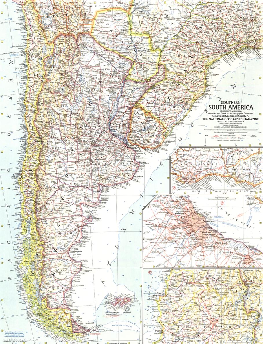
Southern South America Wall Map - Published 1958 by National Geographic
$49.95
Afterpay is only available for orders between $50.00 and $1000.00 More info
Size: 480 × 630 mm | Scale: 1:6,652,800 | Published: 1958 | Made in Australia
🌍 Southern South America in the Mid-20th Century
Travel back to March 1958, when National Geographic unveiled this finely detailed map of Southern South America, capturing a region alive with cultural vibrancy, economic promise, and sweeping natural beauty. Released alongside the feature article "Argentina: Young Giant of the Far South", this edition offers a fascinating portrait of a continent segment at a pivotal time in its post-war development.
This map presents Argentina, Chile, Uruguay, Paraguay, and the southern reaches of Brazil with the precision and elegance for which National Geographic is renowned. Three beautifully illustrated city insets—Buenos Aires, Santiago, and Montevideo—highlight the capitals that have shaped the political and cultural heart of the region.
A perfect historical partner to the 1955 Eastern South America map, it completes a captivating view of the continent’s southern half in the mid-20th century.
📐 Cartographic Highlights
-
Three Detailed City Insets – Buenos Aires, Santiago, and Montevideo presented in crisp, scaled layouts.
-
Political Borders & Capitals – Clear demarcation of nations and key cities.
-
Relief Shading – Brings mountain ranges, plains, and coastal forms to life.
-
Mid-Century National Geographic Styling – Warm, balanced colour palette and fine cartographic lettering.
-
Historic Context – Published during a period of rapid economic and infrastructure growth.
🖌 Premium Print & Display Options
| Format | Description |
|---|---|
| Paper (160 gsm) | Heavyweight matte-coated paper – perfect for framing under glass. |
| Laminated | Fully encapsulated in two sheets of 80-micron gloss laminate for superior durability. |
| Laminated + Hang Rails | Laminate-finished map fitted with natural timber hang rails and a cord for easy display. |
| Canvas (395 gsm) | Printed on HP Professional Matte Canvas with archival pigment inks for rich texture and fade resistance. |
| Canvas + Hang Rails | Canvas map mounted with natural timber hang rails for an elegant, heritage-style presentation. |
Note: Please allow up to 10 working days for delivery of hang-railed maps, as each is professionally mounted by our framer.
🎯 Ideal For
-
Collectors – An authentic reproduction from National Geographic’s golden age of cartography.
-
Historians & Educators – A visual record of Southern South America’s political and cultural landscape in the late 1950s.
-
Decorators – Adds sophistication to offices, libraries, or travel-themed interiors.
-
Travel Enthusiasts – Inspiring for those exploring South America’s southern cone.
🌟 Why Choose This Map?
-
Historic Detail – A rare mid-century view of Argentina, Chile, Uruguay, Paraguay, and southern Brazil.
-
Renowned Craftsmanship – National Geographic’s award-winning cartographic style.
-
Long-Lasting Quality – Produced in Australia with archival-grade materials.
-
Display Versatility – Multiple formats to suit collectors, educators, or home decorators.
Step into the Southern South America of 1958, where vibrant capitals met sweeping pampas, Andean peaks, and rich cultural traditions. Whether as a collector’s piece, a decorative statement, or an educational resource, this National Geographic map offers a window into a world on the move.
📍 Order now to secure your museum-quality reproduction of one of National Geographic’s most elegant South American maps.
Frequently Asked Questions
What are the dimensions of the Southern South America Wall Map - Published 1958 by National Geographi?
Mapworld wall maps range from standard 700×1000mm to large-format 1000×1430mm Supermaps. The exact dimensions for this map are shown in the product title. Where multiple sizes are available, select your preferred size when adding to cart.
Is this wall map available laminated?
Many Mapworld wall maps are available in paper, laminated, or framed finishes. Check the product options when adding to cart. Laminated maps are wipe-clean and more durable.
Is this the latest edition?
Mapworld stocks the most current editions available from all publishers. Edition year is shown in the product title where applicable. Mapworld updates its catalogue as new editions are released.
Can I write on or pin this wall map?
Laminated wall maps can be written on with whiteboard markers and wiped clean. Paper maps can be pinned on a corkboard. Choose a laminated option for a writeable surface.
Does Mapworld ship the Southern South America Wall Map - Published 1958 by National Geographi across Australia?
Yes, Mapworld ships Australia-wide. Standard shipping is a flat $7 rate, with free standard shipping on orders over $75. Express options are available at checkout. Most orders placed before 2pm AEST on weekdays are dispatched same day.
Related Items


© 2026 Mapworld. Website designed by Genie Media
X