- Australia ▾
- Topographic
▾
- Australia AUSTopo 250k (2025)
- Australia 50k Geoscience maps
- Australia 100k Geoscience maps
- Australia 250k Geoscience maps
- Australia 1:1m Geoscience maps
- New Zealand 50k maps
- New Zealand 250k maps
- New South Wales 25k maps
- New South Wales 50k maps
- New South Wales 100k maps
- Queensland 10k maps
- Queensland 25k maps
- Queensland 50k maps
- Queensland 100k maps
- Western Australia 25k maps
- Western Australia 50k maps
- Western Australia 100k maps
- Compasses
- Software
- GPS Systems
- International ▾
- Wall Maps
▾
- World
- Australia & New Zealand
- Countries, Continents & Regions
- Historical
- Vintage National Geographic
- Australian Capital Territory
- New South Wales
- Northern Territory
- Queensland
- South Australia
- Tasmania
- Victoria
- Western Australia
- Celestial
- Children's
- Mining & Resources
- Wine Maps
- Healthcare
- Postcode Maps
- Electoral Maps
- Nautical ▾
- Flags
▾
- Australian Flag Sets & Banners
- Flag Bunting
- Handwavers
- Australian National Flags
- Aboriginal Flags
- Torres Strait Islander Flags
- International Flags
- Flagpoles & Accessories
- Australian Capital Territory Flags
- New South Wales Flags
- Northern Territory Flags
- Queensland Flags
- South Australia Flags
- Tasmania Flags
- Victoria Flags
- Western Australia Flags
- Gifts ▾
- Globes ▾
Dear valued customer. Please note that our checkout is not supported by old browsers. Please use a recent browser to access all checkout capabilities


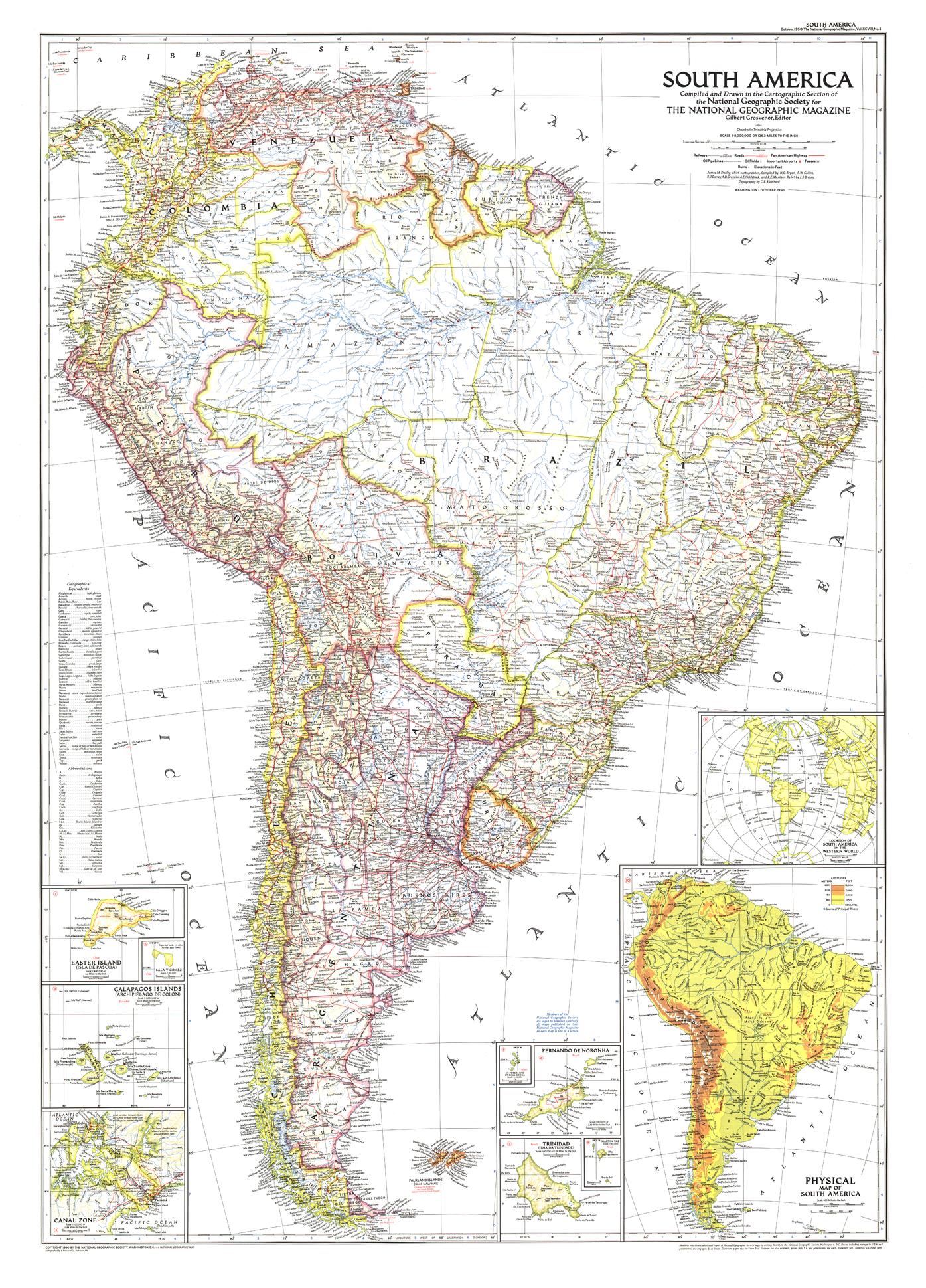
South America Wall Map - Published 1950 by National Geographic
$69.95
or make 4 interest-free payments of
$17.49 AUD
fortnightly with
![]() More info
More info
Size: 738 × 1026 mm | Scale: 1:8,000,000 | Published: 1950 | Made in Australia
🌍 South America at the Dawn of the Jet Age
Step back to October 1950, when National Geographic unveiled this richly detailed political and physical map of South America—a continent on the cusp of transformative change. Accompanying three major feature articles, including the evocative "Peru, Homeland of the Warlike Inca", this edition marked a milestone in the Society’s cartography: it was the first map of the continent to depict airports, signalling the arrival of a new era in aviation and connectivity.
Beyond the skies, the map captures a South America where roads and railways were expanding, with new routes under construction linking distant regions for the first time. This was a moment when ancient cultures, colonial legacies, and modern ambitions intertwined—perfectly reflected in the careful artistry and accuracy of National Geographic’s mid-century cartographers.
📐 Cartographic Highlights
-
First Appearance of Airports – A pioneering inclusion, marking the continent’s growing air infrastructure.
-
Transport in Transition – Railways, major roads, and routes under construction meticulously marked.
-
Physical & Political Clarity – Countries in distinct colours with clear international borders.
-
Inset Details – Geographic insets offering deeper context to key areas.
-
Classic 1950 National Geographic Styling – Rich colouration and detailed relief shading.
🖌 Premium Print & Display Options
| Format | Description |
|---|---|
| Paper (160 gsm) | Heavyweight matte-coated paper – ideal for archival framing under glass. |
| Laminated | Fully encapsulated in two sheets of 80-micron gloss laminate for outstanding durability. |
| Laminated + Hang Rails | Laminated map with smooth natural timber rails and a hanging cord – display-ready. |
| Canvas (395 gsm) | Printed on HP Professional Matte Canvas with archival pigment inks for rich texture and fade resistance. |
| Canvas + Hang Rails | Canvas map finished with natural timber hang rails for a timeless, heritage display. |
Note: Please allow up to 10 working days for delivery of hang-railed maps, as each is professionally mounted by our framer.
🎯 Ideal For
-
Collectors – Own an authentic reproduction of a pivotal 20th-century National Geographic map.
-
Aviation Enthusiasts – See the continent at the birth of its commercial air travel era.
-
Educators & Historians – A resource for teaching the political, cultural, and infrastructural history of South America.
-
Decorators – A striking centrepiece for libraries, studies, offices, or travel-inspired spaces.
🌟 Why Choose This Map?
-
Historic Significance – First South America map to feature airports, capturing a moment of global connectivity.
-
Meticulous Detail – Every route, border, and topographical feature rendered with precision.
-
Enduring Quality – Printed in Australia to professional archival standards.
-
Display Versatility – Available in paper, laminated, and premium canvas formats.
Bring the South America of 1950 into your home, office, or classroom—a continent poised between its storied past and a rapidly modernising future. This National Geographic original blends artistry, geography, and history into one unforgettable wall map.
📍 Order yours today and own a museum-quality reproduction of one of National Geographic’s most historically significant South American maps.
Frequently Asked Questions
What are the dimensions of the South America Wall Map - Published 1950 by National Geographic?
Mapworld wall maps range from standard 700×1000mm to large-format 1000×1430mm Supermaps. The exact dimensions for this map are shown in the product title. Where multiple sizes are available, select your preferred size when adding to cart.
Is this wall map available laminated?
Many Mapworld wall maps are available in paper, laminated, or framed finishes. Check the product options when adding to cart. Laminated maps are wipe-clean and more durable.
Is this the latest edition?
Mapworld stocks the most current editions available from all publishers. Edition year is shown in the product title where applicable. Mapworld updates its catalogue as new editions are released.
Can I write on or pin this wall map?
Laminated wall maps can be written on with whiteboard markers and wiped clean. Paper maps can be pinned on a corkboard. Choose a laminated option for a writeable surface.
Does Mapworld ship the South America Wall Map - Published 1950 by National Geographic across Australia?
Yes, Mapworld ships Australia-wide. Standard shipping is a flat $7 rate, with free standard shipping on orders over $75. Express options are available at checkout. Most orders placed before 2pm AEST on weekdays are dispatched same day.
Related Items


© 2026 Mapworld. Website designed by Genie Media
X