- Australia ▾
- Topographic
▾
- Australia AUSTopo 250k (2025)
- Australia 50k Geoscience maps
- Australia 100k Geoscience maps
- Australia 250k Geoscience maps
- Australia 1:1m Geoscience maps
- New Zealand 50k maps
- New Zealand 250k maps
- New South Wales 25k maps
- New South Wales 50k maps
- New South Wales 100k maps
- Queensland 10k maps
- Queensland 25k maps
- Queensland 50k maps
- Queensland 100k maps
- Western Australia 25k maps
- Western Australia 50k maps
- Western Australia 100k maps
- Compasses
- Software
- GPS Systems
- International ▾
- Wall Maps
▾
- World
- Australia & New Zealand
- Countries, Continents & Regions
- Historical
- Vintage National Geographic
- Australian Capital Territory
- New South Wales
- Northern Territory
- Queensland
- South Australia
- Tasmania
- Victoria
- Western Australia
- Celestial
- Children's
- Mining & Resources
- Wine Maps
- Healthcare
- Postcode Maps
- Electoral Maps
- Nautical ▾
- Flags
▾
- Australian Flag Sets & Banners
- Flag Bunting
- Handwavers
- Australian National Flags
- Aboriginal Flags
- Torres Strait Islander Flags
- International Flags
- Flagpoles & Accessories
- Australian Capital Territory Flags
- New South Wales Flags
- Northern Territory Flags
- Queensland Flags
- South Australia Flags
- Tasmania Flags
- Victoria Flags
- Western Australia Flags
- Gifts ▾
- Globes ▾
Dear valued customer. Please note that our checkout is not supported by old browsers. Please use a recent browser to access all checkout capabilities


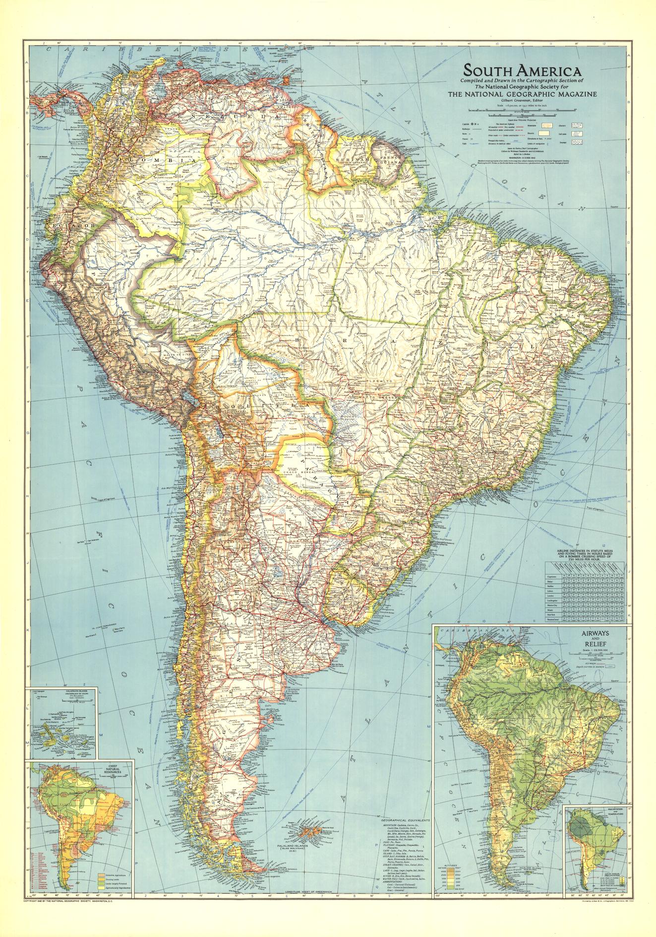
South America Wall Map - Published 1942 by National Geographic
$69.95
or make 4 interest-free payments of
$17.49 AUD
fortnightly with
![]() More info
More info
Scale: 1:8,500,000 | Published: 1942 | Made in Australia
🌎 South America in a World at War
When National Geographic released this 1942 edition of its South America wall map, the world was deep in the midst of the Second World War. While much of the northern hemisphere was engulfed in conflict, South America remained a largely untouched expanse of roadless interiors, uncharted river systems, and vast, wild landscapes.
This map captures the continent at a critical historical moment — a region of immense natural resources and strategic importance, yet still home to remote frontiers. The vibrant colours and fine cartography typical of National Geographic of the era bring to life both the political divisions and the physical grandeur of the land.
Detailed insets of the Galapagos Islands, along with climate and precipitation data, airway routes, and shaded relief, offer a richly layered geographic and environmental picture. This is not just a political map — it is a visual record of South America’s place in the world during one of the most defining decades of the 20th century.
📜 Historical Significance
-
Wartime Cartography – Produced during WWII, reflecting both scientific precision and geopolitical awareness.
-
Comprehensive Insets – Galapagos Islands, climate charts, airways, and relief data for a multi-dimensional view.
-
Pre-Modern Transport Era – Before the continent’s vast highway networks were built.
📐 Map Specifications
-
Scale: 1:8,500,000
-
Size: 700 mm (wide) x 999 mm (high)
-
Projection: Balanced for clarity and geographic accuracy.
-
Reproduction Quality: Faithful to the original 1942 printing with every line and colour detail preserved.
🖌 Premium Finishing Options
| Format | Description |
|---|---|
| Paper (160 gsm) | Heavyweight matte-coated paper — perfect for framing under glass. |
| Laminated | Encapsulated in 80-micron gloss laminate for durability and easy cleaning. |
| Laminated + Hang Rails | Ready-to-hang with natural timber rails and cord for instant display. |
| Canvas (395 gsm) | Museum-grade matte canvas with archival pigment inks for exceptional texture and fade resistance. |
| Canvas + Hang Rails | Canvas with timber hang rails for a warm, heritage-style presentation. |
Framing Note: Please allow up to 10 working days for hang-railed maps, as they are custom-mounted by our framer.
🎯 Ideal For
-
Historians & Collectors – A wartime geographic record of South America.
-
Educators – An engaging teaching tool for history, geography, and world affairs.
-
Travel Enthusiasts – A snapshot of the continent before modern development.
-
Decor & Display – Adds depth, heritage, and intrigue to libraries, offices, or study spaces.
🌟 Why Choose This Map?
-
Captures South America at a pivotal moment in global history.
-
Blends artistry, cartography, and historical context.
-
Available in multiple premium display formats.
-
Made in Australia using archival-quality materials.
Add a rare and historically rich piece of cartographic art to your wall. This National Geographic 1942 South America map is more than a map — it’s a time capsule of an extraordinary era.
🛒 Order now and preserve a piece of history in your home, office, or classroom.
Frequently Asked Questions
What are the dimensions of the South America Wall Map - Published 1942 by National Geographic?
Mapworld wall maps range from standard 700×1000mm to large-format 1000×1430mm Supermaps. The exact dimensions for this map are shown in the product title. Where multiple sizes are available, select your preferred size when adding to cart.
Is this wall map available laminated?
Many Mapworld wall maps are available in paper, laminated, or framed finishes. Check the product options when adding to cart. Laminated maps are wipe-clean and more durable.
Is this the latest edition?
Mapworld stocks the most current editions available from all publishers. Edition year is shown in the product title where applicable. Mapworld updates its catalogue as new editions are released.
Can I write on or pin this wall map?
Laminated wall maps can be written on with whiteboard markers and wiped clean. Paper maps can be pinned on a corkboard. Choose a laminated option for a writeable surface.
Does Mapworld ship the South America Wall Map - Published 1942 by National Geographic across Australia?
Yes, Mapworld ships Australia-wide. Standard shipping is a flat $7 rate, with free standard shipping on orders over $75. Express options are available at checkout. Most orders placed before 2pm AEST on weekdays are dispatched same day.
Related Items


© 2026 Mapworld. Website designed by Genie Media
X