- Australia ▾
- Topographic
▾
- Australia AUSTopo 250k (2025)
- Australia 50k Geoscience maps
- Australia 100k Geoscience maps
- Australia 250k Geoscience maps
- Australia 1:1m Geoscience maps
- New Zealand 50k maps
- New Zealand 250k maps
- New South Wales 25k maps
- New South Wales 50k maps
- New South Wales 100k maps
- Queensland 10k maps
- Queensland 25k maps
- Queensland 50k maps
- Queensland 100k maps
- Compasses
- Software
- GPS Systems
- Orienteering
- International ▾
- Wall Maps
▾
- World
- Australia & New Zealand
- Countries, Continents & Regions
- Historical
- Vintage National Geographic
- Australian Capital Territory
- New South Wales
- Northern Territory
- Queensland
- South Australia
- Tasmania
- Victoria
- Western Australia
- Celestial
- Children's
- Mining & Resources
- Wine Maps
- Healthcare
- Postcode Maps
- Electoral Maps
- Nautical ▾
- Flags
▾
- Australian Flag Sets & Banners
- Flag Bunting
- Handwavers
- Australian National Flags
- Aboriginal Flags
- Torres Strait Islander Flags
- International Flags
- Flagpoles & Accessories
- Australian Capital Territory Flags
- New South Wales Flags
- Northern Territory Flags
- Queensland Flags
- South Australia Flags
- Tasmania Flags
- Victoria Flags
- Western Australia Flags
- Gifts ▾
- Globes ▾
Dear valued customer. Please note that our checkout is not supported by old browsers. Please use a recent browser to access all checkout capabilities
Children's Physical Map of South America 668 x 905mm
$59.95
or make 4 interest-free payments of
$14.99 AUD
fortnightly with
![]() More info
More info
Scale: 1:8,400,000 | Size: 668 × 905 mm | Published: 2019 | Made in Australia
🌎 A Map Every Child Can Enjoy and Understand
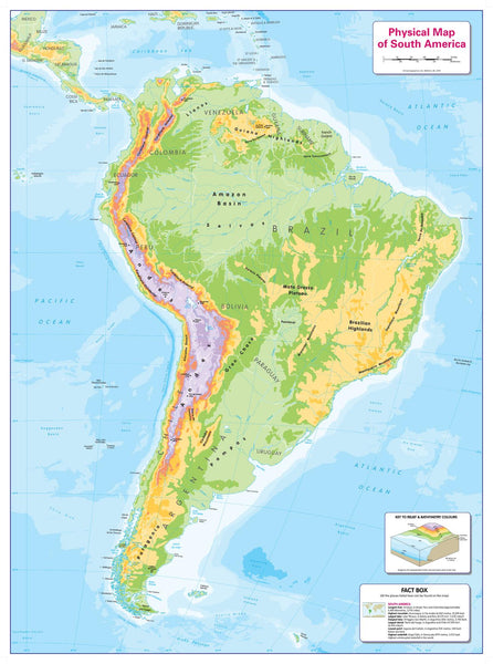
Every classroom should have maps that all students can use and enjoy — regardless of visual ability. This Children’s Physical Map of South America has been specially designed to be fully accessible to children with any form of colour blindness.
Its clear, high-contrast colours and thoughtful design ensure that no child is excluded from engaging with geography. Major physical features are beautifully illustrated — from the towering Andes Mountains and the lush Amazon Basin to the Patagonian steppes and surrounding seas. Even the seabed is depicted, helping children understand the connection between land and ocean geography.
A handy facts box provides quick, engaging information about South America, making it perfect for stimulating curiosity in both home and classroom settings.
📐 Map Specifications
-
Scale: 1:8,400,000
-
Size: 668 mm (wide) × 905 mm (high)
-
Content: Major physical features, ocean floor relief, key facts for learning.
-
Accessibility: Fully colour blind–friendly design.
-
Publication Year: 2019
-
Made in Australia
🖌 Premium Finishing Options
| Format | Description |
|---|---|
| Paper (160 gsm) | Heavyweight matte-coated paper — perfect for framing under glass. |
| Laminated | Encapsulated in 80-micron gloss laminate for long-lasting durability. |
| Laminated + Hang Rails | Ready-to-hang with natural timber rails and cord for instant display. |
| Canvas (395 gsm) | Museum-grade matte canvas with archival pigment inks for exceptional colour and fade resistance. |
| Canvas + Hang Rails | Canvas with natural timber hang rails for a warm, heritage look. |
Framing Note: Please allow up to 10 working days for hang-railed maps, as they are professionally mounted by our framer.
🎯 Perfect For
-
Classrooms – Supports inclusive teaching and visual learning for all students.
-
Home Learning – Encourages curiosity and independent study.
-
Educational Gifts – A thoughtful and practical present for geography-loving children.
-
Decor – Bright and engaging, ideal for playrooms and study areas.
🌟 Why This Map Stands Out
-
Inclusive by Design – Crafted so children with any form of colour blindness can read it easily.
-
Visually Engaging – Striking colours and simple labelling for young learners.
-
Educational & Fun – Combines physical geography with fascinating facts.
-
Built to Last – Premium materials for years of enjoyment and study.
Bring South America’s landscapes, mountains, and rivers to life for every child — in a format they can all enjoy and learn from.
Order today and make geography truly inclusive in your home or classroom.


