- Australia ▾
- Topographic
▾
- Australia AUSTopo 250k (2024)
- Australia 50k Geoscience maps
- Australia 100k Geoscience maps
- Australia 250k Geoscience maps
- Australia 1.1m Geoscience maps
- New Zealand 50k maps
- New Zealand 250k maps
- New South Wales 25k maps
- New South Wales 50k maps
- New South Wales 100k maps
- Queensland 10k maps
- Queensland 25k maps
- Queensland 50k maps
- Queensland 100k maps
- Compasses
- Software
- GPS Systems
- Orienteering
- International ▾
- Wall Maps
▾
- World
- Australia & New Zealand
- Countries, Continents & Regions
- Historical
- Vintage National Geographic
- Australian Capital Territory
- New South Wales
- Northern Territory
- Queensland
- South Australia
- Tasmania
- Victoria
- Western Australia
- Celestial
- Children's
- Mining & Resources
- Wine Maps
- Healthcare
- Postcode Maps
- Electoral Maps
- Nautical ▾
- Flags
▾
- Australian Flag Sets & Banners
- Flag Bunting
- Handwavers
- Australian National Flags
- Aboriginal Flags
- Torres Strait Islander Flags
- International Flags
- Flagpoles & Accessories
- Australian Capital Territory Flags
- New South Wales Flags
- Northern Territory Flags
- Queensland Flags
- South Australia Flags
- Tasmania Flags
- Victoria Flags
- Western Australia Flags
- Gifts ▾
- Globes ▾
Dear valued customer. Please note that our checkout is not supported by old browsers. Please use a recent browser to access all checkout capabilities
Sydney & Region Hema 700 x 1000mm Paper Wall Map
$89.95
or make 4 interest-free payments of
$22.49 AUD
fortnightly with
![]() More info
More info
Size: 700 mm (W) x 1000 mm (H) | Scale: 1:100,000
Detailed paper wall map for business, education, logistics, and planning
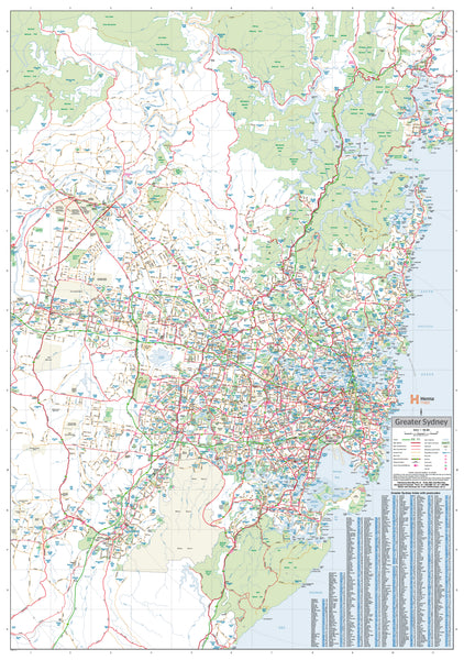
Explore Australia’s largest metropolitan area in striking detail with the Sydney & Region Wall Map by Hema Maps. Covering the full extent of Greater Sydney, this map reaches from Gosford on the Central Coast in the north to Sutherland Shire in the south, and as far west as Penrith—capturing key transport corridors, natural landmarks, and postcode boundaries in one clear, comprehensive view.
Perfect for planners, educators, local councils, real estate professionals, and businesses needing postcode and road network visibility, this wall map balances functionality with clarity. Whether you’re identifying logistics zones, planning customer outreach, or teaching regional geography, this Hema map provides an accessible and authoritative visual reference.
✅ Key Features
-
Full Greater Sydney Coverage
Includes Central Coast (Gosford), Blue Mountains (Penrith), Sutherland, and everything in between. -
Road Network Clarity
All major and secondary roads are clearly shown, including:-
Metroad numbers
-
State and national route markings
-
Existing and planned freeways
-
-
Postcode Boundaries
Clearly outlined postcodes make this map invaluable for:-
Sales and service territory planning
-
Courier and logistics operations
-
Urban and regional analysis
-
-
Urban Planning Insights
An excellent overview for understanding Sydney’s spatial structure—from the CBD to suburban growth corridors.
🖨️ Print & Material Specifications
-
Printed on Premium 160 gsm Satin Art Paper
Sturdy yet refined, this heavyweight paper is perfect for framing under glass or using directly on walls. -
Pigment-Based Fade-Resistant Inks
Printed with long-lasting, archival-quality Hewlett-Packard pigment inks that resist fading over time. -
Crisp Cartographic Detailing
Created by Hema Maps, one of Australia’s most trusted map publishers, known for accuracy and readability.
📐 Technical Details
| Specification | Detail |
|---|---|
| Title | Sydney & Region Map |
| Publisher | Hema Maps |
| Scale | 1:100,000 |
| Size | 700 mm (W) × 1000 mm (H) |
| Material | 160 gsm Satin Art Paper |
| Ink | HP Pigment-Based, Fade-Resistant |
| Format | Flat (Unfolded) Wall Map |
| Country of Origin | Made in Australia |
🏢 Who Is This Map For?
-
Business Owners & Service Providers – plot delivery zones, clients, or regional offices
-
Educators & Students – great for geography, history, and civic planning
-
Councils & Urban Planners – for regional development and infrastructure projects
-
Real Estate Agents – visualise and explain regional coverage and postcode zones to clients
-
Retail & Sales Teams – ideal for sales rep territories and regional coverage maps
Optional Finishing Formats
If you’d like this map in a more durable or display-ready format, we can also provide:
-
Laminated version – allows whiteboard markers and map dots, perfect for interactive use
-
Canvas version (395 gsm HP Matte Canvas) – printed with archival pigment ink for museum-quality presentation
-
Canvas with Hang Rails – supplied with natural timber battening and a hanging cord, ready to display
Bring Sydney into focus—plan smarter, teach clearer, and make decisions with confidence using this clear, precise, and up-to-date Sydney & Region Hema Wall Map. A practical and professional addition to any office, classroom, or operations centre.


