- Australia ▾
- Topographic
▾
- Australia AUSTopo 250k (2025)
- Australia 50k Geoscience maps
- Australia 100k Geoscience maps
- Australia 250k Geoscience maps
- Australia 1:1m Geoscience maps
- New Zealand 50k maps
- New Zealand 250k maps
- New South Wales 25k maps
- New South Wales 50k maps
- New South Wales 100k maps
- Queensland 10k maps
- Queensland 25k maps
- Queensland 50k maps
- Queensland 100k maps
- Western Australia 25k maps
- Western Australia 50k maps
- Western Australia 100k maps
- Compasses
- Software
- GPS Systems
- International ▾
- Wall Maps
▾
- World
- Australia & New Zealand
- Countries, Continents & Regions
- Historical
- Vintage National Geographic
- Australian Capital Territory
- New South Wales
- Northern Territory
- Queensland
- South Australia
- Tasmania
- Victoria
- Western Australia
- Celestial
- Children's
- Mining & Resources
- Wine Maps
- Healthcare
- Postcode Maps
- Electoral Maps
- Nautical ▾
- Flags
▾
- Australian Flag Sets & Banners
- Flag Bunting
- Handwavers
- Australian National Flags
- Aboriginal Flags
- Torres Strait Islander Flags
- International Flags
- Flagpoles & Accessories
- Australian Capital Territory Flags
- New South Wales Flags
- Northern Territory Flags
- Queensland Flags
- South Australia Flags
- Tasmania Flags
- Victoria Flags
- Western Australia Flags
- Gifts ▾
- Globes ▾
Dear valued customer. Please note that our checkout is not supported by old browsers. Please use a recent browser to access all checkout capabilities


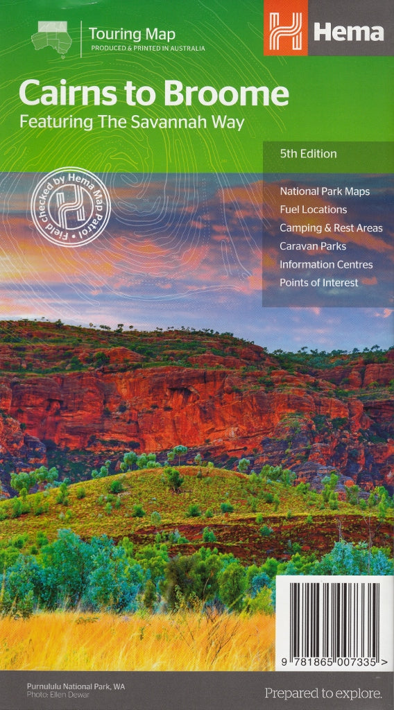
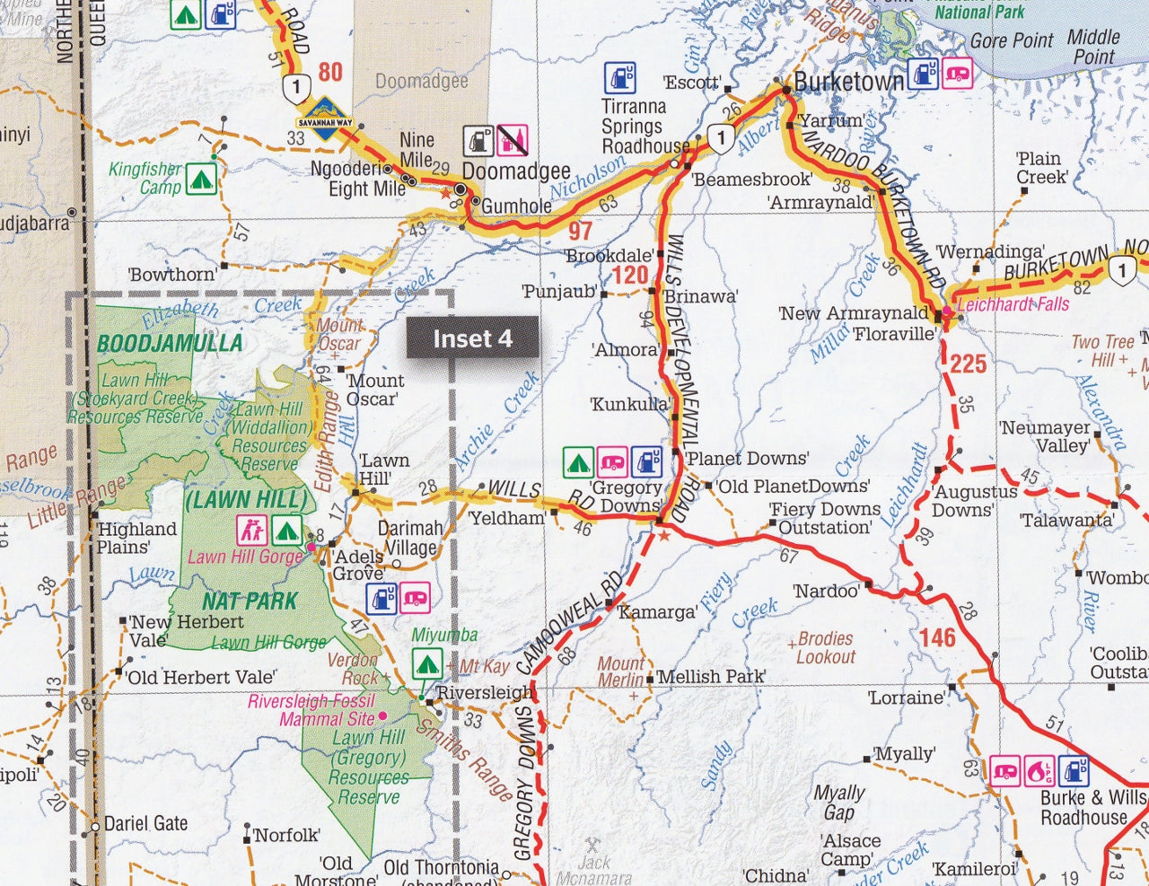
Savannah Way Cairns to Broome Hema Map 5th Edition
$14.95 $15.95
Afterpay is only available for orders between $50.00 and $1000.00 More info
Your essential guide to the legendary 3,700 km outback adventure across Australia's Top End.
The Savannah Way Cairns to Broome Map (5th Edition) by Hema Maps is the definitive map for one of Australia’s greatest overland journeys. Stretching from the tropical coastline of Cairns in Queensland to the remote pearling town of Broome in Western Australia, the Savannah Way traverses five major bioregions, countless national parks, historic outposts, ancient gorges, and pristine wilderness—much of it accessible only via 4WD routes and adventurous detours.
This map is tailor-made for 4WD travellers, caravanners, campers, and long-distance explorers, and is packed with up-to-date touring information, detailed topographic references, and extensive resources for planning and navigating safely across northern Australia.
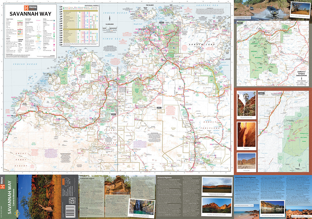
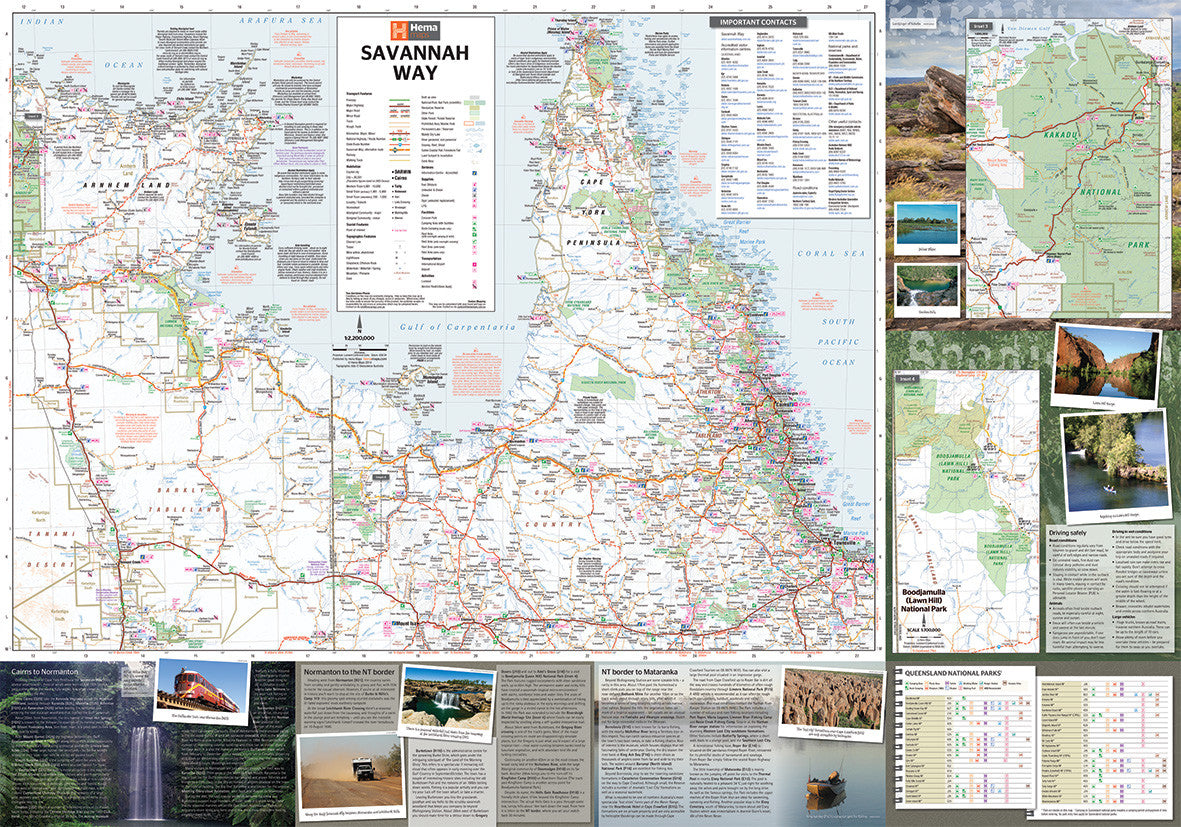
🗺️ Area Coverage
-
Start Point: Cairns, QLD
-
End Point: Broome, WA
-
Passes Through:
-
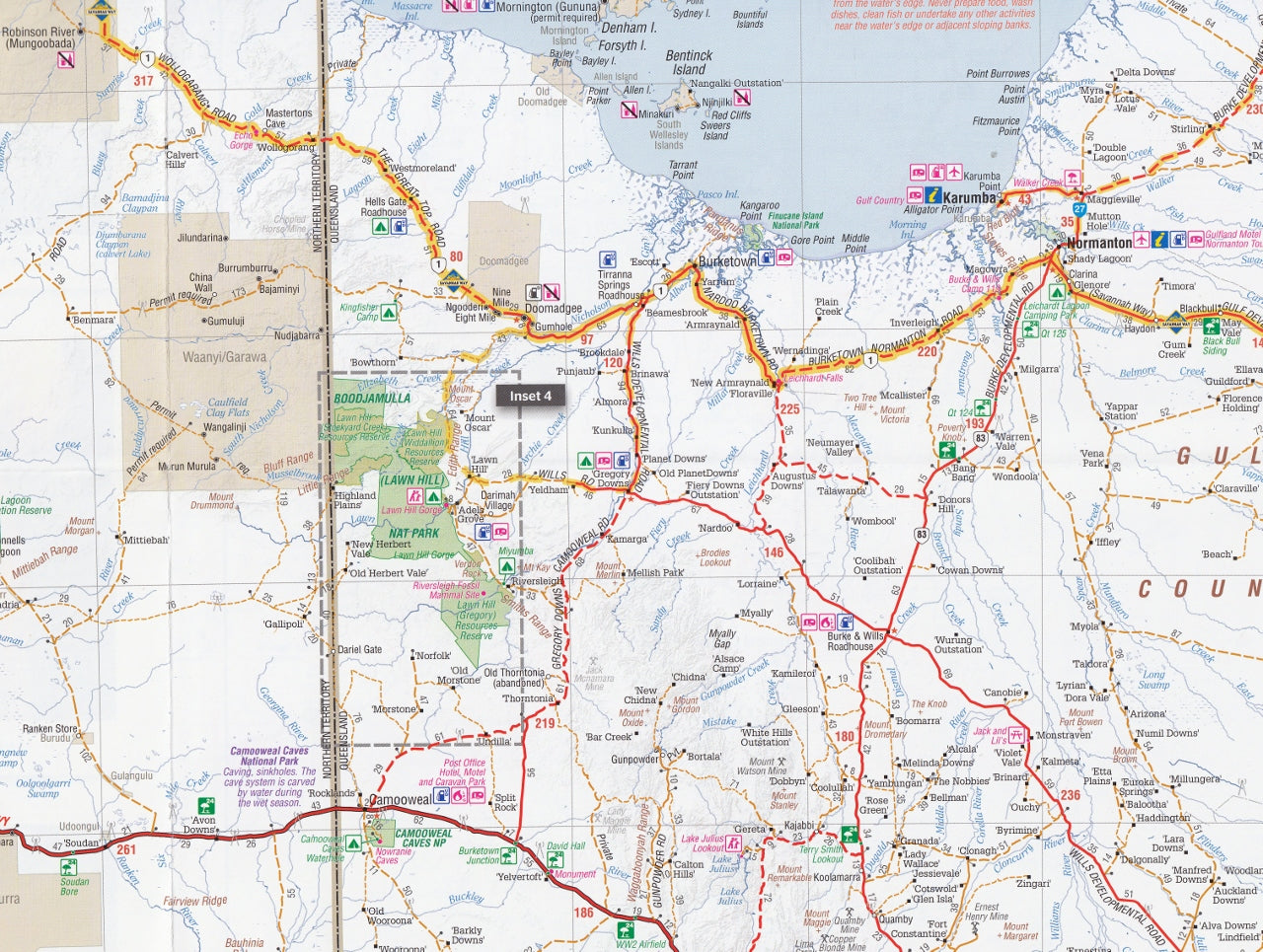
Gulf Country and Boodjamulla (Lawn Hill) National Park
-
Katherine, Mataranka, and the Bitter Springs
-
The extraordinary wetlands of Kakadu National Park
-
Timber Creek and the Victoria River District
-
The Kimberley region, including Lake Argyle, Purnululu (Bungle Bungles), Halls Creek, Fitzroy Crossing, and finally Broome
-
This journey crosses three time zones and some of the most spectacular outback landscapes in Australia.
🧭 Map Features
-
Scale: 1:2,200,000 – ideal for route planning with regional context
-
Detailed route mapping of the entire Savannah Way, including sealed roads, unsealed roads, and major detours
-
Inset National Park maps:
-
Kakadu National Park
-
Boodjamulla (Lawn Hill)
-
Judbarra/Gregory National Park
-
Purnululu National Park (Bungle Bungles)
-
-
Camping and Accommodation Symbols:
-
Caravan parks
-
National park campsites
-
Roadside rest areas
-
Fuel stops and roadhouses
-
24-hour and remote fuel availability
-
Visitor Information Centres with contact details
-
-
Points of Interest: Hot springs, waterfalls, lookout points, Aboriginal rock art sites, gorges, and river crossings
-
Distance Chart: Includes driving distances between key towns and service points
-
Touring Facilities: Rest stops, LPG refuelling, dump points, and mechanical assistance
🧾 Map Specifications
-
Edition: 5th Edition
-
Publication Date: 2014
-
Publisher: Hema Maps
-
Unfolded Size: 700 mm x 1000 mm
-
Folded Size: 140 mm x 250 mm
-
Weight: Approx. 90 grams
-
ISBN: 9781865007335
-
Format: Single-sided, folded map on quality paper stock (not laminated)
🚙 Who Is This Map For?
-
4WD adventurers exploring Australia’s far north via off-road tracks
-
Long-distance caravanners and motorhomers planning cross-country journeys
-
Self-drive tourists navigating Queensland’s Gulf Country and the Kimberley
-
Eco-travellers and nature lovers looking for remote wildlife-rich landscapes
-
Expedition planners and road-tripping families seeking detailed logistical info
-
Grey nomads, backpackers, and overlanders making the most of the dry season loop
🌿 Why Travel the Savannah Way?
-
Cultural experiences: Engage with Aboriginal communities and historic outback towns
-
Natural beauty: Explore World Heritage sites, waterfalls, wildlife reserves, and gorges
-
Diverse ecosystems: Traverse monsoonal rainforests, open savannahs, escarpments, and arid deserts
-
True adventure: Ideal for well-equipped 4WDs and experienced travellers looking for the road less travelled
🔍 Summary
The Savannah Way Cairns to Broome Map (5th Edition) by Hema is the most trusted and comprehensive guide to one of Australia’s greatest overland journeys. With detailed routing, points of interest, and essential planning tools, this map ensures you’re not just getting from point A to B—you’re experiencing every remarkable moment in between.
Unplug. Head west. Let the Savannah Way unfold.
Plan it right. Drive it safely. Discover it all—with Hema.
This map is also available as a laminated map encapsulated in high-quality plastic.
Frequently Asked Questions
Where can I buy the Savannah Way Cairns to Broome Hema Map 5th Edition?
The Savannah Way Cairns to Broome Hema Map 5th Edition is available to buy online from Mapworld, Australia's largest map and geographic product retailer, with fast shipping Australia-wide.
Is the Savannah Way Cairns to Broome Hema Map 5th Edition in stock at Mapworld?
Mapworld maintains extensive stock across its map range and aims for fast dispatch. Orders placed before 2pm AEST on business days are typically dispatched the same day, with standard and express Australia-wide delivery options available.
What is Mapworld's returns policy?
Mapworld accepts returns on undamaged items in original condition. Contact Mapworld within 90 days of purchase to arrange a return or exchange.
Does Mapworld ship the Savannah Way Cairns to Broome Hema Map 5th Edition across Australia?
Yes, Mapworld ships Australia-wide. Standard shipping is a flat $7 rate, with free standard shipping on orders over $75. Express options are available at checkout. Most orders placed before 2pm AEST on weekdays are dispatched same day.
Related Items


© 2026 Mapworld. Website designed by Genie Media
X