- Australia ▾
- Topographic
▾
- Australia AUSTopo 250k (2024)
- Australia 50k Geoscience maps
- Australia 100k Geoscience maps
- Australia 250k Geoscience maps
- Australia 1.1m Geoscience maps
- New Zealand 50k maps
- New Zealand 250k maps
- New South Wales 25k maps
- New South Wales 50k maps
- New South Wales 100k maps
- Queensland 10k maps
- Queensland 25k maps
- Queensland 50k maps
- Queensland 100k maps
- Compasses
- Software
- GPS Systems
- Orienteering
- International ▾
- Wall Maps
▾
- World
- Australia & New Zealand
- Countries, Continents & Regions
- Historical
- Vintage National Geographic
- Australian Capital Territory
- New South Wales
- Northern Territory
- Queensland
- South Australia
- Tasmania
- Victoria
- Western Australia
- Celestial
- Children's
- Mining & Resources
- Wine Maps
- Healthcare
- Postcode Maps
- Electoral Maps
- Nautical ▾
- Flags
▾
- Australian Flag Sets & Banners
- Flag Bunting
- Handwavers
- Australian National Flags
- Aboriginal Flags
- Torres Strait Islander Flags
- International Flags
- Flagpoles & Accessories
- Australian Capital Territory Flags
- New South Wales Flags
- Northern Territory Flags
- Queensland Flags
- South Australia Flags
- Tasmania Flags
- Victoria Flags
- Western Australia Flags
- Gifts ▾
- Globes ▾
Dear valued customer. Please note that our checkout is not supported by old browsers. Please use a recent browser to access all checkout capabilities
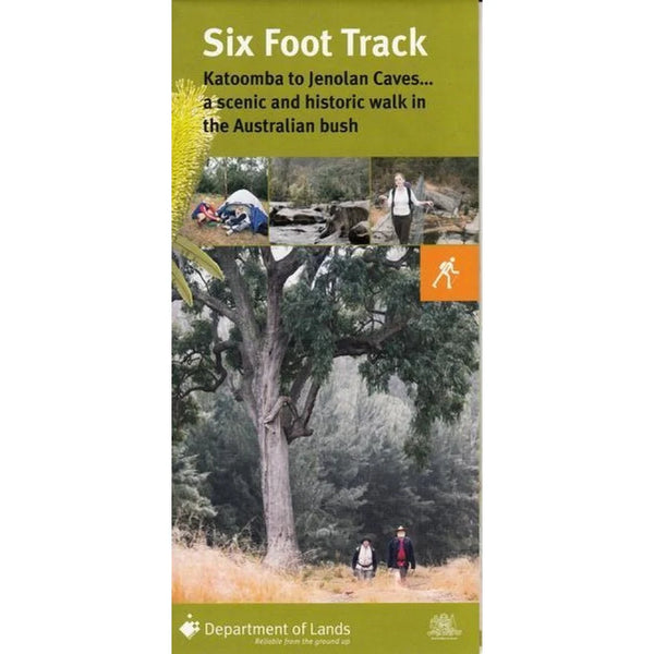
Six Foot Track Map DPE
$14.95
Afterpay is only available for orders between $50.00 and $1000.00 More info
Six Foot Track Map — DPE Official Topographic Walking Map
Katoomba → Jenolan Caves • 42 km • 3 Days • 1:25,000 Scale
🥾 Walk One of Australia’s Classic Trails
Follow in the footsteps of 19th-century explorers with the Six Foot Track, a legendary 42 km heritage trail linking Katoomba in the Blue Mountains to the Jenolan Caves.
This official DPE (NSW Department of Planning and Environment) topographic map is the definitive navigation guide for tackling the entire route — whether you’re planning a full multi-day trek or exploring shorter day sections through the Megalong Valley and Cox’s River.
🗺 Trail Overview
-
Start: Explorer’s Tree, Great Western Highway, Katoomba
-
Route:
-
Descend Nellie’s Glen to the Megalong Valley
-
Cross Cox’s River (noted for its swing bridge and camp area)
-
Climb the Mini Mini Range and Black Range
-
Finish by descending Binoomea Ridge to Jenolan Caves
-
-
Distance: 42 km
-
Duration: 3 days (average pace)
-
Total Elevation: 1,200 m down → 300 m up
-
Trail Type: Fire trail and single-track
-
Recommended Direction: East–West (Katoomba to Jenolan)
⛺️ Campsites & Overnight Stops
Primitive camping is available along the route at:
-
Cox’s River Campground
-
Alum Creek Campground
-
Black Range Campground
All campsites are marked on the map with topographic accuracy, including access points, elevation contours, and watercourses.
⚙️ Trail Difficulty & Surface
-
Grade: Hard – Technical
-
Surface: Rocky, gravel, and clay (varies by section)
-
Trail Type: Fire trail & single-track
-
Best Seasons: Spring & Autumn (mild temperatures and clear conditions)
🌤 Seasonal Conditions
| Season | Average Temp (°C) | Rainfall (mm) |
|---|---|---|
| Summer | 12 – 23 °C | 120 – 175 mm |
| Autumn | 6 – 20 °C | 105 – 165 mm |
| Winter | 3 – 11 °C | 83 – 120 mm |
| Spring | 5 – 20 °C | 70 – 100 mm |
Plan for cooler temperatures at elevation and sudden weather changes, especially during winter months.
🚗 Access & Transport
-
By Car: From Sydney, take the M4 Motorway to the Great Western Highway, then follow Jenolan Caves Road.
-
By Train & Bike: Take a train to Mt Victoria, then cycle along Black Range Road to connect with the track.
-
Parking: Off-street parking available at Black Range Road trailhead.
🚵 Suitable For
-
Hikers — multi-day treks or shorter sections
-
Mountain bikers — selected fire trails only (technical sections)
-
Outdoor educators and adventure guides — topographic-grade reference
🧭 Maps & Navigation
-
Topographic Maps Used:
-
Jenolan – 8930-3N
-
Hampton – 8930-4S
-
Katoomba – 8930-1S
-
LPI Six Foot Track Map (Official)
-
-
Elevation Gain: 1,200 m to 300 m
-
Recommended Gear: compass, topographic map, GPS device, PLB (Personal Locator Beacon)
⚠️ Safety & Leave No Trace
-
Wear appropriate clothing and sturdy hiking footwear.
-
Carry sufficient food and at least 3–4 litres of water per day.
-
Stay on marked trails; respect private property boundaries.
-
Take all rubbish out with you.
-
Bury human waste well away from campsites and streams.
-
Inform a responsible person of your itinerary and expected return.
🛒 Local Services & Support
-
Nearest Bike Shops:
-
Katoomba Bikes, 7 Katoomba St — (02) 4782 5032
-
Velo Nova, 182 Katoomba St — (02) 4782 2800
-
-
Food & Supplies: Available at Hartley and Jenolan Caves villages.
🌿 Things to Do Nearby
-
Hiking and bushwalking
-
Caving and guided tours at Jenolan
-
Camping and photography
-
Horse riding trails
-
Local markets and Blue Mountains lookouts
🧾 Product Specifications
| Feature | Detail |
|---|---|
| Title | Six Foot Track Map – DPE Official Edition |
| Publisher | NSW Department of Planning & Environment |
| Scale | 1 : 25,000 |
| Coverage | Katoomba to Jenolan Caves |
| Trail Length | 42 km |
| Printed Size | 700 mm × 1000 mm |
| Finish | Folded Map |
| Material | 120 gsm matte paper (fade-resistant pigment inks) |
| Origin | Printed in Australia |
🧭 Your Essential Blue Mountains Trekking Companion
Perfect for walkers, adventure travellers, and outdoor educators, the Six Foot Track Topographic Map combines precision, durability, and local expertise.
Plan your hike. Track your ascent. Discover a trail that connects the heart of the Blue Mountains with the spirit of adventure.


