- Australia ▾
- Topographic
▾
- Australia AUSTopo 250k (2025)
- Australia 50k Geoscience maps
- Australia 100k Geoscience maps
- Australia 250k Geoscience maps
- Australia 1:1m Geoscience maps
- New Zealand 50k maps
- New Zealand 250k maps
- New South Wales 25k maps
- New South Wales 50k maps
- New South Wales 100k maps
- Queensland 10k maps
- Queensland 25k maps
- Queensland 50k maps
- Queensland 100k maps
- Western Australia 25k maps
- Western Australia 50k maps
- Western Australia 100k maps
- Compasses
- Software
- GPS Systems
- International ▾
- Wall Maps
▾
- World
- Australia & New Zealand
- Countries, Continents & Regions
- Historical
- Vintage National Geographic
- Australian Capital Territory
- New South Wales
- Northern Territory
- Queensland
- South Australia
- Tasmania
- Victoria
- Western Australia
- Celestial
- Children's
- Mining & Resources
- Wine Maps
- Healthcare
- Postcode Maps
- Electoral Maps
- Nautical ▾
- Flags
▾
- Australian Flag Sets & Banners
- Flag Bunting
- Handwavers
- Australian National Flags
- Aboriginal Flags
- Torres Strait Islander Flags
- International Flags
- Flagpoles & Accessories
- Australian Capital Territory Flags
- New South Wales Flags
- Northern Territory Flags
- Queensland Flags
- South Australia Flags
- Tasmania Flags
- Victoria Flags
- Western Australia Flags
- Gifts ▾
- Globes ▾
Dear valued customer. Please note that our checkout is not supported by old browsers. Please use a recent browser to access all checkout capabilities


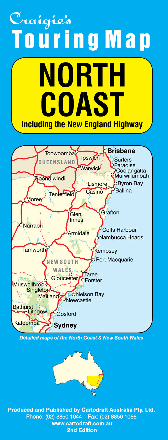
North Coast Craigies Map
$14.95
Afterpay is only available for orders between $50.00 and $1000.00 More info
North Coast Map – Craigies Edition
Your Trusted Guide from Brisbane to Wollongong, Including the Scenic New England Highway
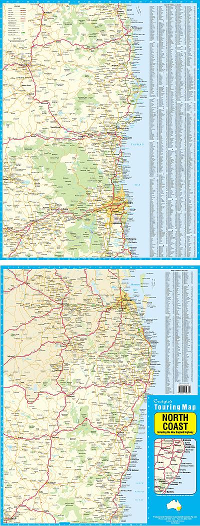
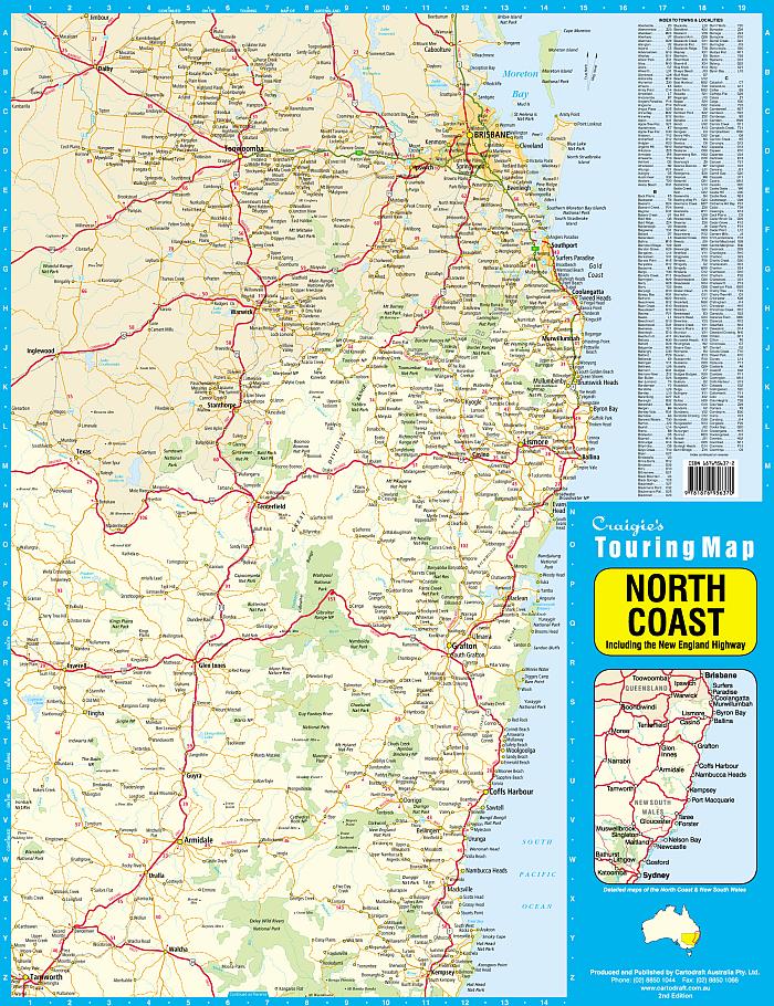
Explore the vibrant landscapes, pristine coastlines, and charming towns of eastern Australia with the Craigies North Coast Map — a large-format, easy-to-read touring map designed for travellers, campers, and professional drivers navigating the iconic corridor between Brisbane and Wollongong.
Stretching across two states and showcasing both the Pacific Highway and New England Highway routes, this map is an ideal companion for holidaymakers taking the scenic route, caravaners planning overnight stays, or locals exploring regional New South Wales and southern Queensland.
🌏 Coverage Area
This comprehensive map extends:
-
North: From Brisbane and the Gold Coast Hinterland
-
South: All the way to Wollongong and the Illawarra region
-
Inland: Incorporating the New England Highway, a favourite for inland travellers and grey nomads
Along the way, it covers key cities, towns, and attractions including:
-
Byron Bay, Ballina, Lismore & Grafton
-
Coffs Harbour, Port Macquarie, Forster & Taree
-
Newcastle, the Central Coast & Sydney
-
Wollongong & the Illawarra Escarpment
-
Armidale, Tamworth, and Glen Innes via the New England inland route
🧭 Map Features
-
✔️ Full Road Network – Including highways, sealed secondary roads, and major tourist drives
-
✔️ New England Highway Coverage – Ideal for alternative touring through the tablelands
-
✔️ National Parks and Forests – Highlighting key areas for hiking, camping, and sightseeing
-
✔️ Towns and Localities – Clearly marked for planning fuel stops, accommodation, and detours
-
✔️ Points of Interest – Lookouts, waterfalls, heritage towns, wineries, and surf beaches
-
✔️ Tourist Icons – Beaches, rest areas, picnic grounds, caravan parks, and more
-
✔️ Distance Indicators – Useful reference points for route planning and travel time estimation
📐 Map Specifications
| Detail | Specification |
|---|---|
| Scale | 1:880,000 |
| Coverage | Brisbane to Wollongong, including inland routes |
| Map Type | Folded Touring Map |
| Style | Full-colour with legend and symbol guide |
| Format | Folded paper – lightweight and easy to use |
🎯 Perfect For:
-
🧭 Tourists exploring Australia’s east coast or inland highways
-
🚐 Caravanners and grey nomads travelling from QLD to NSW
-
🏖️ Beach lovers and surfers seeking hidden gems and main surf breaks
-
🌳 Nature enthusiasts visiting national parks and scenic lookouts
-
🚗 Families planning holiday road trips and regional escapes
-
📦 Drivers and delivery professionals needing clear route guidance
-
🗺️ Anyone needing a regional overview for business or recreation
🌟 Why Choose the Craigies North Coast Map?
Craigies Maps are locally made and trusted by travellers, educators, councils, and tourism operators across Australia. Known for exceptional cartographic accuracy and clarity, this map offers:
-
Smart layout with intuitive navigation and easy-fold handling
-
Legible fonts and symbology for clear reading at a glance
-
Reliable, practical coverage of both coast and inland travel corridors
-
A perfect balance of detail and overview for trip planning or daily use
Plan the Journey. Discover the Coast. Travel with Confidence.
From coastal surf towns and rainforest hinterlands to quiet inland plains and highland towns, the North Coast Craigies Map connects you to the best of eastern Australia. Whether you're cruising the Pacific or winding through the New England tablelands, this map is your essential companion.
Adventure starts with the right map — take Craigies with you.
Frequently Asked Questions
Where can I buy the North Coast Craigies Map?
The North Coast Craigies Map is available to buy online from Mapworld, Australia's largest map and geographic product retailer, with fast shipping Australia-wide.
Is the North Coast Craigies Map in stock at Mapworld?
Mapworld maintains extensive stock across its map range and aims for fast dispatch. Orders placed before 2pm AEST on business days are typically dispatched the same day, with standard and express Australia-wide delivery options available.
What is Mapworld's returns policy?
Mapworld accepts returns on undamaged items in original condition. Contact Mapworld within 90 days of purchase to arrange a return or exchange.
Does Mapworld ship the North Coast Craigies Map across Australia?
Yes, Mapworld ships Australia-wide. Standard shipping is a flat $7 rate, with free standard shipping on orders over $75. Express options are available at checkout. Most orders placed before 2pm AEST on weekdays are dispatched same day.
Related Items


© 2026 Mapworld. Website designed by Genie Media
X