- Australia ▾
- Topographic
▾
- Australia AUSTopo 250k (2024)
- Australia 50k Geoscience maps
- Australia 100k Geoscience maps
- Australia 250k Geoscience maps
- Australia 1.1m Geoscience maps
- New Zealand 50k maps
- New Zealand 250k maps
- New South Wales 25k maps
- New South Wales 50k maps
- New South Wales 100k maps
- Queensland 10k maps
- Queensland 25k maps
- Queensland 50k maps
- Queensland 100k maps
- Compasses
- Software
- GPS Systems
- Orienteering
- International ▾
- Wall Maps
▾
- World
- Australia & New Zealand
- Countries, Continents & Regions
- Historical
- Vintage National Geographic
- Australian Capital Territory
- New South Wales
- Northern Territory
- Queensland
- South Australia
- Tasmania
- Victoria
- Western Australia
- Celestial
- Children's
- Mining & Resources
- Wine Maps
- Healthcare
- Postcode Maps
- Electoral Maps
- Nautical ▾
- Flags
▾
- Australian Flag Sets & Banners
- Flag Bunting
- Handwavers
- Australian National Flags
- Aboriginal Flags
- Torres Strait Islander Flags
- International Flags
- Flagpoles & Accessories
- Australian Capital Territory Flags
- New South Wales Flags
- Northern Territory Flags
- Queensland Flags
- South Australia Flags
- Tasmania Flags
- Victoria Flags
- Western Australia Flags
- Gifts ▾
- Globes ▾
Dear valued customer. Please note that our checkout is not supported by old browsers. Please use a recent browser to access all checkout capabilities
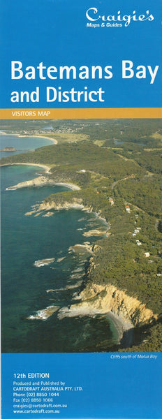
Batemans Bay & District Craigies Map
$14.95
Afterpay is only available for orders between $50.00 and $1000.00 More info
Batemans Bay & District Map by Craigies
Your essential guide to the Eurobodalla Coast — from coastal villages to hinterland hamlets
Discover one of the most spectacular stretches of New South Wales' South Coast with the Craigies Batemans Bay & District Map — a richly detailed and easy-to-use reference for locals, travellers, and outdoor explorers alike. Covering an expansive area from Tabourie Lake in the north to Moruya in the south, this map helps you unlock the charm, history, and beauty of the Eurobodalla region with confidence.
Whether you're planning a coastal getaway, scouting out real estate, managing local services, or simply exploring the region’s natural wonders, this map provides all the clarity and detail you need.
📍 Coverage Area
The map features comprehensive regional and street-level detail, extending across:
-
Northern boundary: Tabourie Lake
-
Southern boundary: Moruya
-
Key towns and villages: Batemans Bay, Mogo, Nelligen, Broulee, Malua Bay, Surf Beach, and many more
From surf beaches and estuaries to bushland retreats and heritage towns, this map covers the full spectrum of the region’s geography and communities.
🧭 Detailed Street Maps Included
On the reverse side, you’ll find clearly labelled street maps for over 20 localities, including:
-
Batemans Bay
-
Batehaven
-
Catalina
-
Denhams Beach
-
Durras & Durras Lake
-
Guerilla Bay
-
Lilli Pilli
-
Long Beach
-
Maloneys Beach
-
Malua Bay
-
Mogo
-
Moruya & Moruya Heads
-
Nelligen
-
Rosedale
-
Sunshine Bay
-
Surf Beach
-
Mossy Point
-
Broulee
-
Bringing you a complete street-level perspective ideal for navigation, planning, and locating local services or holiday spots.
🛣️ Map Scales & Dimensions
| Map Type | Scale | Description |
|---|---|---|
| District Map | 1:110,000 | Ideal for route planning & regional overview |
| Street Maps | 1:30,000 | Perfect for detailed urban navigation |
This dual-scale approach makes it easy to plan your journey across the entire region while also zooming in on key town centres.
🏞️ Features & Highlights
-
✔️ Complete road network, from major highways to minor rural roads
-
✔️ Street grids with labelled street names, parks, and facilities
-
✔️ Beaches, headlands, rivers, and natural landmarks
-
✔️ Local services, including schools, shopping areas, and emergency services
-
✔️ National Parks and State Forest boundaries, including Murramarang and Deua
-
✔️ Tourist highlights such as scenic lookouts, picnic areas, and coastal walks
-
✔️ Waterways and boat access points, including Clyde River and Durras Lake
-
✔️ Neighbouring towns and travel distances between key destinations
🎯 Who Is This Map For?
-
🧳 Holidaymakers and road trippers discovering NSW’s South Coast
-
🚗 Day-trippers and weekenders exploring beaches, markets, or bushwalks
-
🏘️ Local homeowners and real estate professionals needing accurate street-level views
-
🧭 Delivery drivers, tradespeople, and local services operating across the region
-
🧒 Schools, community centres, and tourism operators looking for reliable regional references
-
🏕️ Campers, anglers, and outdoor enthusiasts seeking off-the-beaten-path access
📝 Product Details
| Specification | Description |
|---|---|
| Title | Batemans Bay & District Map |
| Publisher | Craigies Maps |
| Map Coverage | From Tabourie Lake to Moruya |
| Street Maps | Included for 20+ local towns |
| District Map Scale | 1:110,000 |
| Street Map Scale | 1:30,000 |
| Format | Folded paper map |
| Flat Size | Approx. 700 mm (W) × 1000 mm (H) |
| Edition | Latest available |
| Printed in | Australia |
🌿 Explore Eurobodalla Your Way
From the tranquil waters of Broulee and the rugged forest trails near Mogo to the bustling cafes of Batemans Bay and the sleepy shores of Durras Lake, this map helps you make the most of every corner of the region.
Plan your route, find your destination, and experience the magic of the South Coast with the Craigies Batemans Bay & District Map — made for travellers, locals, and adventurers alike.
Get oriented. Stay informed. Travel smarter — with Craigies.


