- Australia ▾
- Topographic
▾
- Australia AUSTopo 250k (2025)
- Australia 50k Geoscience maps
- Australia 100k Geoscience maps
- Australia 250k Geoscience maps
- Australia 1:1m Geoscience maps
- New Zealand 50k maps
- New Zealand 250k maps
- New South Wales 25k maps
- New South Wales 50k maps
- New South Wales 100k maps
- Queensland 10k maps
- Queensland 25k maps
- Queensland 50k maps
- Queensland 100k maps
- Western Australia 25k maps
- Western Australia 50k maps
- Western Australia 100k maps
- Compasses
- Software
- GPS Systems
- International ▾
- Wall Maps
▾
- World
- Australia & New Zealand
- Countries, Continents & Regions
- Historical
- Vintage National Geographic
- Australian Capital Territory
- New South Wales
- Northern Territory
- Queensland
- South Australia
- Tasmania
- Victoria
- Western Australia
- Celestial
- Children's
- Mining & Resources
- Wine Maps
- Healthcare
- Postcode Maps
- Electoral Maps
- Nautical ▾
- Flags
▾
- Australian Flag Sets & Banners
- Flag Bunting
- Handwavers
- Australian National Flags
- Aboriginal Flags
- Torres Strait Islander Flags
- International Flags
- Flagpoles & Accessories
- Australian Capital Territory Flags
- New South Wales Flags
- Northern Territory Flags
- Queensland Flags
- South Australia Flags
- Tasmania Flags
- Victoria Flags
- Western Australia Flags
- Gifts ▾
- Globes ▾
Dear valued customer. Please note that our checkout is not supported by old browsers. Please use a recent browser to access all checkout capabilities


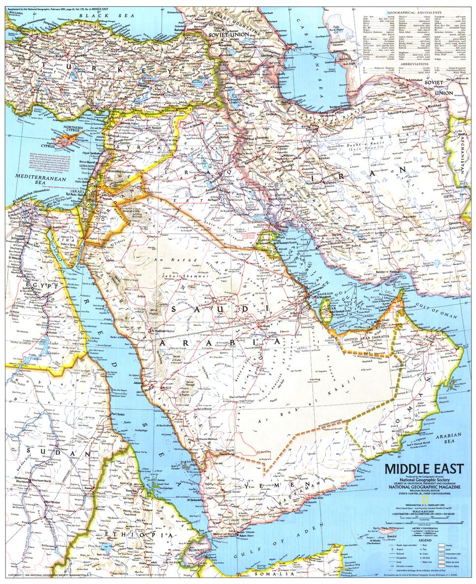
Middle East Wall Map - Published 1991 by National Geographic
$49.95
Afterpay is only available for orders between $50.00 and $1000.00 More info
🌍 Middle East Wall Map – National Geographic
Scale 1:5,877,000 | Published February 1991 | Gulf War Historical Context
Published in February 1991 by National Geographic, this Middle East Wall Map offers an exceptionally detailed look at one of the world’s most strategically important regions during a pivotal moment in modern history — the Gulf War.
The map presents clear political boundaries alongside a wealth of geographic and thematic detail, including:
-
Locations of ruins and archaeological sites
-
Extensive transportation networks, including roads, railways, and shipping routes
-
Oil fields and related infrastructure
-
Cities, towns, and physical landforms
Created as a companion to National Geographic’s The Middle East: States in Turmoil, this map combines accurate cartography with timely geopolitical relevance, making it both a valuable educational tool and a collector’s item.
🗺️ Map Features
-
Political & Geographic Detail – Countries, capitals, major cities, and natural features.
-
Economic & Cultural Highlights – Oil fields, ruins, and key infrastructure.
-
Transport Networks – Roads, railways, ports, and pipelines.
-
Historical Context – Published during the Gulf War for a unique period perspective.
-
National Geographic Quality – Accuracy, readability, and beautiful design.
✨ Available Finishes
| Format | Description |
|---|---|
| 🖨️ Paper (160 gsm) | Heavyweight matte-coated paper — ideal for framing under glass. |
| 🧼 Laminated (Encapsulated) | Fully sealed between two sheets of 80-micron gloss laminate. Wipe-clean, tear-resistant, and durable. |
| 🪵 Laminated with Wooden Hang Rails | Laminated map mounted with natural lacquered timber rails (top and bottom) and a hanging cord — ready to hang. |
| 🖼️ Canvas (395 gsm) | HP Professional Matte Canvas with archival pigment-based inks. Rich texture, fade-resistant, and gallery-quality. |
| 🪵 Canvas with Wooden Hang Rails | Same premium canvas finish, mounted with natural timber rails and a hanging cord for a timeless, ready-to-display look. |
🔨 Please allow up to 10 working days for delivery of hang-railed maps, as these are professionally mounted by our custom framer.
📐 Specifications
| Feature | Detail |
|---|---|
| Title | Middle East Wall Map |
| Publisher | National Geographic |
| Published | February 1991 |
| Scale | 1:5,877,000 |
| Dimensions | 512 mm (W) x 627 mm (H) |
| Materials | 160 gsm paper / 80-micron gloss laminate / 395 gsm HP Matte Canvas |
| Origin | Printed and professionally finished in Australia |
💡 Why You’ll Love This Map
✔️ Captures the Middle East during the Gulf War — a moment of global significance
✔️ Detailed coverage of ruins, oil fields, and transport networks
✔️ Companion to The Middle East: States in Turmoil map for deeper insight
✔️ Available in five premium finishes — from frame-ready paper to ready-to-hang canvas
✔️ Fade-resistant inks and quality materials for decades of clarity
🎯 Perfect For
-
Educational Institutions – Political geography, economics, and history classrooms
-
Libraries & Archives – A historical record from 1991
-
Corporate & Government Offices – Reference for strategic and economic analysis
-
Collectors – A preserved National Geographic map from the Gulf War era
-
Home Display – For history lovers and geography enthusiasts
🚚 Delivery
-
Paper, Laminated, Canvas: Ships within 1–2 business days
-
Hang-railed Maps (Laminated or Canvas): Ships within 10 working days (custom-mounted)
-
Packaging: Rolled in a heavy-duty postal tube for safe arrival
This 1991 Middle East Wall Map is more than a geographic reference — it’s a visual record of a region in the midst of historic change, created with the enduring quality and authority of National Geographic.
👉 Order today to own a cartographic work that blends precision, history, and beauty.
Frequently Asked Questions
What are the dimensions of the Middle East Wall Map - Published 1991 by National Geographic?
Mapworld wall maps range from standard 700×1000mm to large-format 1000×1430mm Supermaps. The exact dimensions for this map are shown in the product title. Where multiple sizes are available, select your preferred size when adding to cart.
Is this wall map available laminated?
Many Mapworld wall maps are available in paper, laminated, or framed finishes. Check the product options when adding to cart. Laminated maps are wipe-clean and more durable.
Is this the latest edition?
Mapworld stocks the most current editions available from all publishers. Edition year is shown in the product title where applicable. Mapworld updates its catalogue as new editions are released.
Can I write on or pin this wall map?
Laminated wall maps can be written on with whiteboard markers and wiped clean. Paper maps can be pinned on a corkboard. Choose a laminated option for a writeable surface.
Does Mapworld ship the Middle East Wall Map - Published 1991 by National Geographic across Australia?
Yes, Mapworld ships Australia-wide. Standard shipping is a flat $7 rate, with free standard shipping on orders over $75. Express options are available at checkout. Most orders placed before 2pm AEST on weekdays are dispatched same day.
Related Items


© 2026 Mapworld. Website designed by Genie Media
X