- Australia ▾
- Topographic
▾
- Australia AUSTopo 250k (2025)
- Australia 50k Geoscience maps
- Australia 100k Geoscience maps
- Australia 250k Geoscience maps
- Australia 1:1m Geoscience maps
- New Zealand 50k maps
- New Zealand 250k maps
- New South Wales 25k maps
- New South Wales 50k maps
- New South Wales 100k maps
- Queensland 10k maps
- Queensland 25k maps
- Queensland 50k maps
- Queensland 100k maps
- Western Australia 25k maps
- Western Australia 50k maps
- Western Australia 100k maps
- Compasses
- Software
- GPS Systems
- International ▾
- Wall Maps
▾
- World
- Australia & New Zealand
- Countries, Continents & Regions
- Historical
- Vintage National Geographic
- Australian Capital Territory
- New South Wales
- Northern Territory
- Queensland
- South Australia
- Tasmania
- Victoria
- Western Australia
- Celestial
- Children's
- Mining & Resources
- Wine Maps
- Healthcare
- Postcode Maps
- Electoral Maps
- Nautical ▾
- Flags
▾
- Australian Flag Sets & Banners
- Flag Bunting
- Handwavers
- Australian National Flags
- Aboriginal Flags
- Torres Strait Islander Flags
- International Flags
- Flagpoles & Accessories
- Australian Capital Territory Flags
- New South Wales Flags
- Northern Territory Flags
- Queensland Flags
- South Australia Flags
- Tasmania Flags
- Victoria Flags
- Western Australia Flags
- Gifts ▾
- Globes ▾
Dear valued customer. Please note that our checkout is not supported by old browsers. Please use a recent browser to access all checkout capabilities


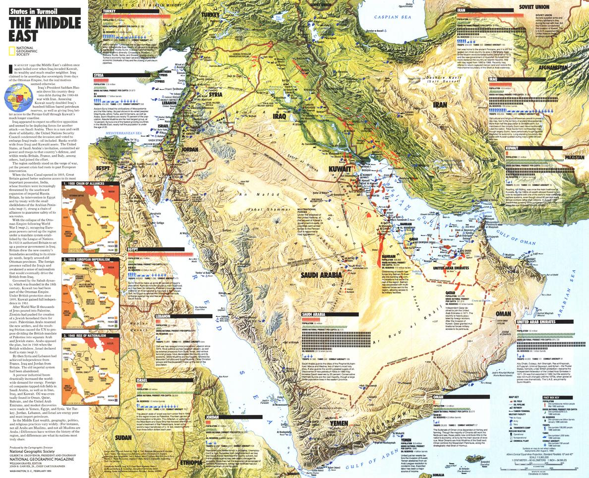
Middle East, States in Turmoil Wall Map - Published 1991 by National Geographic
$49.95
Afterpay is only available for orders between $50.00 and $1000.00 More info
🌍 Middle East, States in Turmoil Wall Map – National Geographic
Scale 1:5,963,000 | Published February 1991 | Gulf War Historical Context
Published in February 1991 by National Geographic, the Middle East, States in Turmoil Wall Map offers a detailed and timely view of the region during one of the most critical geopolitical periods of the late 20th century — the Gulf War.
Designed as a political and thematic reference, this map goes beyond borders and place names, presenting a wealth of country-by-country data, including:
-
Military facilities and troop numbers
-
Oil reserves and production
-
Population statistics
-
Gross national product (GNP)
-
Strategic locations and infrastructure
An overview of the Gulf War is also included, providing essential historical context. Originally issued as a supplement to National Geographic’s The Middle East wall map, this edition is both an educational resource and a collectible historical record.
🗺️ Map Features
-
Political Boundaries – Countries, capitals, major cities, and key borders as of 1991.
-
Thematic Data – Military, economic, and demographic information for each nation.
-
Gulf War Overview – Summary of events, alliances, and outcomes.
-
Strategic Infrastructure – Military bases, oil fields, and transport routes.
-
National Geographic Cartography – Accuracy, clarity, and visually engaging design.
✨ Available Finishes
| Format | Description |
|---|---|
| 🖨️ Paper (160 gsm) | Heavyweight matte-coated paper — perfect for framing under glass. |
| 🧼 Laminated (Encapsulated) | Sealed between two sheets of 80-micron gloss laminate for a wipe-clean, tear-resistant finish. |
| 🪵 Laminated with Wooden Hang Rails | Laminated map mounted with natural lacquered timber rails (top and bottom) and a hanging cord — ready to hang. |
| 🖼️ Canvas (395 gsm) | HP Professional Matte Canvas with archival pigment-based inks. Rich in texture, fade-resistant, and gallery-quality. |
| 🪵 Canvas with Wooden Hang Rails | Canvas mounted with natural timber rails and a hanging cord for a timeless, display-ready look. |
🔨 Please allow up to 10 working days for delivery of hang-railed maps, as these are professionally mounted by our custom framer.
📐 Specifications
| Feature | Detail |
|---|---|
| Title | Middle East, States in Turmoil Wall Map |
| Publisher | National Geographic |
| Published | February 1991 |
| Scale | 1:5,963,000 |
| Dimensions | 629 mm (W) x 510 mm (H) |
| Materials | 160 gsm paper / 80-micron gloss laminate / 395 gsm HP Matte Canvas |
| Origin | Printed and professionally finished in Australia |
💡 Why You’ll Love This Map
✔️ Captures the Middle East during the Gulf War — a pivotal moment in recent history
✔️ Rich in military, economic, and demographic data
✔️ National Geographic design and accuracy
✔️ Available in five premium finishes — from frame-ready to instant wall display
✔️ Printed with fade-resistant inks for decades of clarity
🎯 Perfect For
-
Educational Institutions – Political science, history, and geography classrooms
-
Libraries & Archives – A historical record of the early 1990s Middle East
-
Corporate & Government Offices – Strategic and historical reference
-
Collectors – A preserved National Geographic Gulf War-era map
-
Home Display – For history enthusiasts and geopolitical scholars
🚚 Delivery
-
Paper, Laminated, Canvas: Ships within 1–2 business days
-
Hang-railed Maps (Laminated or Canvas): Ships within 10 working days (custom-mounted)
-
Packaging: Rolled in a heavy-duty postal tube for safe arrival
This Middle East, States in Turmoil Wall Map is both a historical artefact and an informative reference, capturing the political and military realities of the region at the height of the Gulf War.
👉 Order today to own a cartographic record of a defining moment in modern Middle Eastern history.
Frequently Asked Questions
What are the dimensions of the Middle East, States in Turmoil Wall Map - Published 1991 by National G?
Mapworld wall maps range from standard 700×1000mm to large-format 1000×1430mm Supermaps. The exact dimensions for this map are shown in the product title. Where multiple sizes are available, select your preferred size when adding to cart.
Is this wall map available laminated?
Many Mapworld wall maps are available in paper, laminated, or framed finishes. Check the product options when adding to cart. Laminated maps are wipe-clean and more durable.
Is this the latest edition?
Mapworld stocks the most current editions available from all publishers. Edition year is shown in the product title where applicable. Mapworld updates its catalogue as new editions are released.
Can I write on or pin this wall map?
Laminated wall maps can be written on with whiteboard markers and wiped clean. Paper maps can be pinned on a corkboard. Choose a laminated option for a writeable surface.
Does Mapworld ship the Middle East, States in Turmoil Wall Map - Published 1991 by National G across Australia?
Yes, Mapworld ships Australia-wide. Standard shipping is a flat $7 rate, with free standard shipping on orders over $75. Express options are available at checkout. Most orders placed before 2pm AEST on weekdays are dispatched same day.
Related Items


© 2026 Mapworld. Website designed by Genie Media
X