- Australia ▾
- Topographic
▾
- Australia AUSTopo 250k (2025)
- Australia 50k Geoscience maps
- Australia 100k Geoscience maps
- Australia 250k Geoscience maps
- Australia 1:1m Geoscience maps
- New Zealand 50k maps
- New Zealand 250k maps
- New South Wales 25k maps
- New South Wales 50k maps
- New South Wales 100k maps
- Queensland 10k maps
- Queensland 25k maps
- Queensland 50k maps
- Queensland 100k maps
- Western Australia 25k maps
- Western Australia 50k maps
- Western Australia 100k maps
- Compasses
- Software
- GPS Systems
- International ▾
- Wall Maps
▾
- World
- Australia & New Zealand
- Countries, Continents & Regions
- Historical
- Vintage National Geographic
- Australian Capital Territory
- New South Wales
- Northern Territory
- Queensland
- South Australia
- Tasmania
- Victoria
- Western Australia
- Celestial
- Children's
- Mining & Resources
- Wine Maps
- Healthcare
- Postcode Maps
- Electoral Maps
- Nautical ▾
- Flags
▾
- Australian Flag Sets & Banners
- Flag Bunting
- Handwavers
- Australian National Flags
- Aboriginal Flags
- Torres Strait Islander Flags
- International Flags
- Flagpoles & Accessories
- Australian Capital Territory Flags
- New South Wales Flags
- Northern Territory Flags
- Queensland Flags
- South Australia Flags
- Tasmania Flags
- Victoria Flags
- Western Australia Flags
- Gifts ▾
- Globes ▾
Dear valued customer. Please note that our checkout is not supported by old browsers. Please use a recent browser to access all checkout capabilities


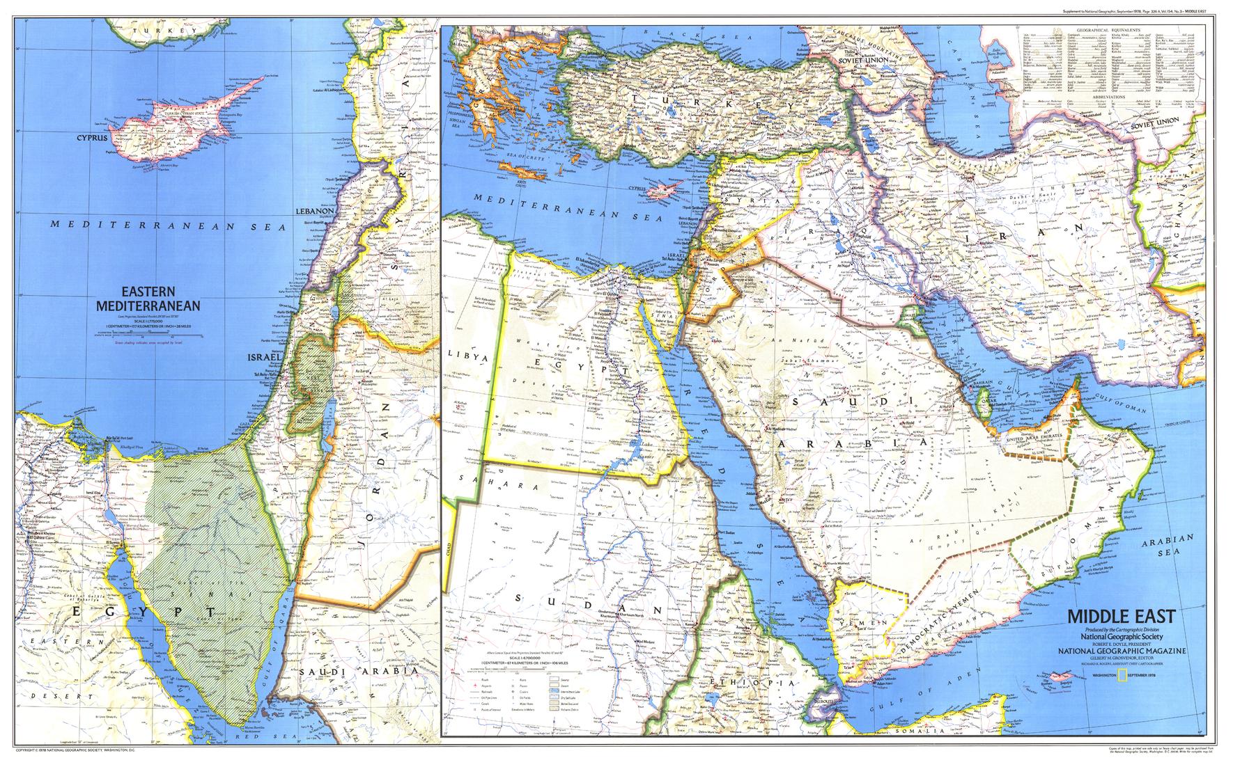
Middle East Wall Map - Published 1978 by National Geographic
$69.95
or make 4 interest-free payments of
$17.49 AUD
fortnightly with
![]() More info
More info
🌍 Middle East Wall Map – National Geographic
Scale 1:6,700,000 | Published September 1978 | Historical & Political Context
Published in September 1978 by National Geographic, this Middle East Wall Map offers a detailed geographic and political snapshot of the region at a crucial moment in modern history.
When the map was created, Israel had occupied the West Bank, Sinai Peninsula, and Golan Heights for over a decade following the Six-Day War of 1967. Just six months after its publication, the Israel–Egypt Peace Treaty was signed, marking Israel’s withdrawal from the Sinai Peninsula and the evacuation of settlements established there in the 1970s.
This map was originally issued as a companion to National Geographic’s historical map "Early Civilizations in the Middle East", combining the publisher’s cartographic precision with the political realities of the time. Today, it stands as both a historical record and a collectible reference for students of Middle Eastern history.
🗺️ Map Features
-
Detailed Political Boundaries – Countries, capitals, major cities, and key transport routes.
-
Regional Context – Covers the Middle East in its entirety with accurate 1978 political borders.
-
Historical Significance – Captures a critical pre-treaty moment in Middle Eastern geopolitics.
-
National Geographic Quality – Clarity, accuracy, and aesthetic appeal in equal measure.
✨ Available Finishes
| Format | Description |
|---|---|
| 🖨️ Paper (160 gsm) | Heavyweight matte-coated paper — perfect for framing under glass. |
| 🧼 Laminated (Encapsulated) | Sealed between two sheets of 80-micron gloss laminate. Wipe-clean, tear-resistant, and durable. |
| 🪵 Laminated with Wooden Hang Rails | Laminated map mounted with natural lacquered timber rails (top and bottom) and a hanging cord — ready to hang. |
| 🖼️ Canvas (395 gsm) | HP Professional Matte Canvas with archival pigment-based inks. Rich texture, fade-resistant, and gallery-quality. |
| 🪵 Canvas with Wooden Hang Rails | Same premium canvas finish, mounted with lacquered timber rails and a hanging cord for a timeless, display-ready look. |
🔨 Please allow up to 10 working days for delivery of hang-railed maps, as each is professionally mounted by our custom framer.
📐 Specifications
| Feature | Detail |
|---|---|
| Title | Middle East Wall Map |
| Publisher | National Geographic |
| Published | September 1978 |
| Scale | 1:6,700,000 |
| Dimensions | 937 mm (W) x 578 mm (H) |
| Materials | 160 gsm paper / 80-micron gloss laminate / 395 gsm HP Matte Canvas |
| Origin | Printed and professionally finished in Australia |
💡 Why You’ll Love This Map
✔️ Historical 1978 edition capturing the political reality before the Israel–Egypt Peace Treaty
✔️ Companion to the Early Civilizations in the Middle East map for richer context
✔️ Five premium finishes — from frame-ready paper to ready-to-hang canvas
✔️ Fade-resistant printing and robust materials for long-term enjoyment
✔️ Ideal for collectors, educators, and those with a passion for Middle Eastern history
🎯 Perfect For
-
Educational Institutions – Political history, geography, and Middle Eastern studies
-
Corporate & Government Offices – Strategic reference and display
-
Collectors & Archivists – A preserved political map from a pivotal year
-
Home Display – A decorative piece with meaningful historical context
🚚 Delivery
-
Paper, Laminated, Canvas: Ships within 1–2 business days
-
Hang-railed Maps (Laminated or Canvas): Ships within 10 working days (custom-mounted)
-
Packaging: Rolled in a heavy-duty postal tube for safe arrival
This 1978 Middle East Wall Map is more than a geographic reference — it is a visual record of a region on the brink of historic change, crafted with the enduring quality of National Geographic.
👉 Order today and bring a piece of Middle Eastern history to your wall.
Frequently Asked Questions
What are the dimensions of the Middle East Wall Map - Published 1978 by National Geographic?
Mapworld wall maps range from standard 700×1000mm to large-format 1000×1430mm Supermaps. The exact dimensions for this map are shown in the product title. Where multiple sizes are available, select your preferred size when adding to cart.
Is this wall map available laminated?
Many Mapworld wall maps are available in paper, laminated, or framed finishes. Check the product options when adding to cart. Laminated maps are wipe-clean and more durable.
Is this the latest edition?
Mapworld stocks the most current editions available from all publishers. Edition year is shown in the product title where applicable. Mapworld updates its catalogue as new editions are released.
Can I write on or pin this wall map?
Laminated wall maps can be written on with whiteboard markers and wiped clean. Paper maps can be pinned on a corkboard. Choose a laminated option for a writeable surface.
Does Mapworld ship the Middle East Wall Map - Published 1978 by National Geographic across Australia?
Yes, Mapworld ships Australia-wide. Standard shipping is a flat $7 rate, with free standard shipping on orders over $75. Express options are available at checkout. Most orders placed before 2pm AEST on weekdays are dispatched same day.
Related Items


© 2026 Mapworld. Website designed by Genie Media
X