- Australia ▾
- Topographic
▾
- Australia AUSTopo 250k (2025)
- Australia 50k Geoscience maps
- Australia 100k Geoscience maps
- Australia 250k Geoscience maps
- Australia 1:1m Geoscience maps
- New Zealand 50k maps
- New Zealand 250k maps
- New South Wales 25k maps
- New South Wales 50k maps
- New South Wales 100k maps
- Queensland 10k maps
- Queensland 25k maps
- Queensland 50k maps
- Queensland 100k maps
- Western Australia 25k maps
- Western Australia 50k maps
- Western Australia 100k maps
- Compasses
- Software
- GPS Systems
- International ▾
- Wall Maps
▾
- World
- Australia & New Zealand
- Countries, Continents & Regions
- Historical
- Vintage National Geographic
- Australian Capital Territory
- New South Wales
- Northern Territory
- Queensland
- South Australia
- Tasmania
- Victoria
- Western Australia
- Celestial
- Children's
- Mining & Resources
- Wine Maps
- Healthcare
- Postcode Maps
- Electoral Maps
- Nautical ▾
- Flags
▾
- Australian Flag Sets & Banners
- Flag Bunting
- Handwavers
- Australian National Flags
- Aboriginal Flags
- Torres Strait Islander Flags
- International Flags
- Flagpoles & Accessories
- Australian Capital Territory Flags
- New South Wales Flags
- Northern Territory Flags
- Queensland Flags
- South Australia Flags
- Tasmania Flags
- Victoria Flags
- Western Australia Flags
- Gifts ▾
- Globes ▾
Dear valued customer. Please note that our checkout is not supported by old browsers. Please use a recent browser to access all checkout capabilities


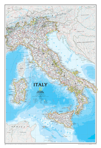
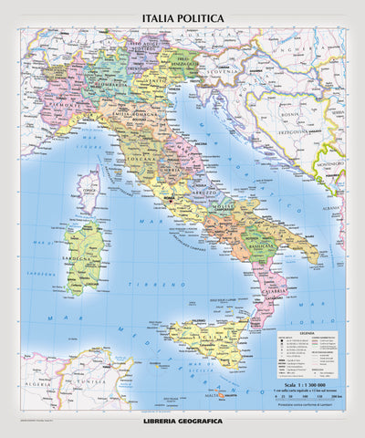
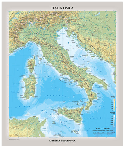
Italy Atlas of the World, 11th Edition, National Geographic Wall Map
$69.95
or make 4 interest-free payments of
$17.49 AUD
fortnightly with
![]() More info
More info
🇮🇹 Italy Wall Map – National Geographic
Atlas of the World, 11th Edition (2019)
Sizes: Standard – 798 × 610 mm | Supermap – 915 × 1197 mm
🗺️ A timeless celebration of Italy’s beauty, culture, and geography.
From the snow-capped Alps to the sun-drenched coasts of Sicily, this exquisite wall map of Italy reveals the full majesty of the Bel Paese. Originally featured in National Geographic’s prestigious 11th Edition Atlas of the World, this standalone map blends physical and political features into a breathtaking and practical reference.
Whether you're a teacher, a traveller, a historian, or a lover of all things Italian — this map offers an extraordinary window into one of the world’s most captivating countries.
✨ Why You'll Love This Map
✅ Cartographic Authority – From National Geographic, trusted worldwide for over 120 years.
✅ Detailed & Distinctive – Clearly marks cities, regional borders, rivers, mountain ranges, roads, and surrounding seas.
✅ Breathtaking Terrain Relief – See the Apennines rise, the Po Valley stretch, and the Mediterranean shimmer.
✅ Inspiring & Informative – Ideal for learning, teaching, decorating, or planning your next Italian adventure.
🧭 Key Map Features
-
🗺️ Physical & Political Boundaries: Italian regions, neighbouring countries, and natural features.
-
🏞️ Shaded Relief: Topography brought to life — mountain ranges, rivers, and coastlines in vivid detail.
-
🌊 Surrounding Waters: Adriatic, Ionian, Tyrrhenian, and Ligurian Seas beautifully rendered.
-
🧭 Projection: Albers Conic Equal-Area — reduces distortion across Italy’s vertical expanse.
-
🏛️ Major Cities Included: Rome, Milan, Naples, Florence, Venice, Bologna, Palermo, Turin, and more.
-
🏞️ Additional Highlights: Island territories (Sardinia and Sicily), bordering nations, and neighbouring seas.
📐 Specifications at a Glance
| Feature | Details |
|---|---|
| Map Title | Italy – National Geographic Atlas of the World, 11th Edition |
| Published | 2019 |
| Cartographer | National Geographic Society |
| Projection | Albers Conic Equal-Area |
| Languages | English |
| Scale | Regional detail suitable for educational, decorative, or professional use |
🖨️ Format & Material Options
| Format | Material | Benefits |
|---|---|---|
| 🗺️ Paper (Unlaminated) | 160 gsm Premium Matte-Coated Paper | Ideal for framing behind glass – smooth and glare-free |
| 💧 Laminated | Dual-sided 80-micron Gloss Laminate | Durable, water-resistant, and wipeable – great for classrooms |
| 🖼️ Canvas | 395 gsm HP Professional Matte Canvas | Fade-resistant, gallery-grade – rich texture and vivid ink |
| 🪵 Canvas + Timber Rails | Canvas + Top & Bottom Natural Timber Rails | Ready to hang – adds warmth and style to your space |
| 🪵 Laminated + Timber Rails | Laminated + Wooden Rails | Sturdy, stylish, and easily wall-mounted |
📏 Available Sizes
| Size | Dimensions (W × H) | Recommended For |
|---|---|---|
| Standard | 798 × 610 mm | Compact display – perfect for desks, nooks, or classrooms |
| Supermap | 915 × 1197 mm | Full-size feature – ideal for living rooms or offices |
🛠️ Hanging & Framing
-
Canvas & Laminated Maps can be supplied with timber hang rails, top and bottom, in a natural lacquer finish.
-
The top rail includes a hanging cord, so installation is as simple as placing a hook in your wall.
-
Please allow 10 working days for delivery of hang-railed maps, as each piece is hand-finished by our professional framer in Australia.
🌍 Who Is This Map For?
-
Teachers wanting to explore Italy’s geography in classrooms.
-
Travellers planning road trips through Tuscany or coastal journeys along the Amalfi.
-
Italian families and expats celebrating their heritage.
-
History buffs following the traces of Rome, Florence, and Venice.
-
Interior decorators seeking timeless, intelligent wall art.
Bring the soul of Italy into your space — from the Alpine north to the volcanic south — with this extraordinary National Geographic map.
🛒 Add to your collection today and let the beauty of Italy guide your next journey.
Frequently Asked Questions
What does the Italy Atlas of the World, 11th Edition, National Geographic Wall Map cover?
This atlas covers the geographic region indicated in the product title, including roads, towns, distances, and key travel information. Mapworld stocks atlases for Australian states and territories, 4WD regions, and international destinations.
Is this the latest edition?
Yes, this is the 11th Edition. Mapworld stocks the most current editions available from publishers.
Is this atlas or guide spiral bound?
Spiral binding is indicated in the product title where applicable. Spiral-bound atlases and guides lay flat when open, making them ideal for use in vehicles or on a table without needing to hold pages open.
Is the Italy Atlas of the World, 11th Edition, National Geographic Wall Map in stock at Mapworld?
Mapworld maintains extensive stock across its map range and aims for fast dispatch. Orders placed before 2pm AEST on business days are typically dispatched the same day, with standard and express Australia-wide delivery options available.
Does Mapworld ship the Italy Atlas of the World, 11th Edition, National Geographic Wall Map across Australia?
Yes, Mapworld ships Australia-wide. Standard shipping is a flat $7 rate, with free standard shipping on orders over $75. Express options are available at checkout. Most orders placed before 2pm AEST on weekdays are dispatched same day.
Related Items
© 2026 Mapworld. Website designed by Genie Media
X