- Australia ▾
- Topographic
▾
- Australia AUSTopo 250k (2025)
- Australia 50k Geoscience maps
- Australia 100k Geoscience maps
- Australia 250k Geoscience maps
- Australia 1:1m Geoscience maps
- New Zealand 50k maps
- New Zealand 250k maps
- New South Wales 25k maps
- New South Wales 50k maps
- New South Wales 100k maps
- Queensland 10k maps
- Queensland 25k maps
- Queensland 50k maps
- Queensland 100k maps
- Western Australia 25k maps
- Western Australia 50k maps
- Western Australia 100k maps
- Compasses
- Software
- GPS Systems
- International ▾
- Wall Maps
▾
- World
- Australia & New Zealand
- Countries, Continents & Regions
- Historical
- Vintage National Geographic
- Australian Capital Territory
- New South Wales
- Northern Territory
- Queensland
- South Australia
- Tasmania
- Victoria
- Western Australia
- Celestial
- Children's
- Mining & Resources
- Wine Maps
- Healthcare
- Postcode Maps
- Electoral Maps
- Nautical ▾
- Flags
▾
- Australian Flag Sets & Banners
- Flag Bunting
- Handwavers
- Australian National Flags
- Aboriginal Flags
- Torres Strait Islander Flags
- International Flags
- Flagpoles & Accessories
- Australian Capital Territory Flags
- New South Wales Flags
- Northern Territory Flags
- Queensland Flags
- South Australia Flags
- Tasmania Flags
- Victoria Flags
- Western Australia Flags
- Gifts ▾
- Globes ▾
Dear valued customer. Please note that our checkout is not supported by old browsers. Please use a recent browser to access all checkout capabilities


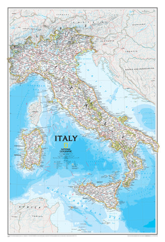
Italy National Geographic 591 x 867mm Wall Map
$59.95
or make 4 interest-free payments of
$14.99 AUD
fortnightly with
![]() More info
More info
🇮🇹 Italy Wall Map – National Geographic
Classic Political Map | Detailed Terrain & Infrastructure | Premium Display Options
Celebrate the beauty, complexity, and history of Italy with this Classic National Geographic Wall Map, the most detailed and visually stunning overview of the country available. From the Alps to the Amalfi Coast, this map captures Italy’s rich geography, vibrant cities, and iconic islands with exceptional clarity and artistry.
Whether you're planning your next trip, decorating a study, or teaching the intricacies of Italian geography, this map offers both function and finesse.
🗺️ A Comprehensive Map of Italy & Its Islands
This map includes:
-
🏛️ Thousands of place names, including cities, towns, and heritage sites
-
🌍 Accurate political boundaries and provincial borders
-
🛤️ Infrastructure details: roads, aqueducts, railways, ferry routes, canals, and airports
-
🏞️ Shaded relief and bathymetric contours, providing a true sense of terrain and coastal features
-
🏔️ Elevation markings for major peaks (in feet) and depth soundings (in fathoms)
-
🏝️ Outlying islands featured: Sardinia, Sicily, Corsica, Elba, Lipari, Isola di Pantelleria, Isola San Domino, Isola di Ustica, and the Isole Eolie
Rendered in National Geographic’s classic cartographic style, this map combines timeless design with meticulous detail—perfect for homes, libraries, offices, and classrooms.
🖼️ Premium Finishes Available
Choose the ideal format to suit your space and style:
| Format | Description |
|---|---|
| 📜 Paper (170 gsm) | Printed on high-quality heavyweight matte-coated paper. Ideal for framing under glass with a clean, archival finish. |
| 🧼 Laminated (Encapsulated) | Sealed between two layers of 80-micron gloss laminate. Wipe-clean, durable, and perfect for classrooms or frequent handling. |
| 🪵 Laminated with Wooden Hang Rails | Laminated and professionally mounted with natural timber hang rails and a hanging cord. A practical and elegant ready-to-hang option. |
| 🖼️ Canvas (395 gsm) | Printed on HP Professional Matte Canvas using pigment-based archival inks. Gallery-quality texture and fade resistance for long-term display. |
| 🪵 Canvas with Wooden Hang Rails | The premium presentation. Canvas map mounted with lacquered timber rails (top and bottom) and a strong hanging cord. Sophisticated and timeless. |
🔨 Please allow up to 10 working days for delivery of hang-railed maps, as each one is professionally mounted by our framer.
📐 Specifications
| Feature | Detail |
|---|---|
| Title | Italy Wall Map |
| Publisher | National Geographic |
| Map Style | Classic Political with Physical Relief |
| Dimensions | 591 mm (W) x 867 mm (H) |
| Scale | Approx. 1:2,000,000 |
| Material Options | Paper, Laminated, Canvas, With or Without Timber Rails |
| Printed & Mounted In | Australia |
💡 Why You'll Love This Map
✔️ National Geographic’s most detailed wall map of Italy
✔️ Beautifully shaded relief and depth contours for geographic realism
✔️ Includes all major islands and maritime routes
✔️ Ideal for planning, teaching, or décor
✔️ High-quality, archival materials for lasting beauty
✔️ Printed and finished in Australia
🎁 A Thoughtful Gift for...
-
Italian heritage families and travellers
-
Teachers and language instructors
-
Travel planners and tour operators
-
Lovers of European geography and history
-
Interior decorators seeking a meaningful centrepiece
🚚 Shipping & Production Notes
-
Paper, laminated, and rolled canvas versions ship within 1–2 business days
-
Hang-railed formats require up to 10 working days for professional mounting
-
All items are shipped from Australia with secure, protective packaging
🗺️ Bring Italy’s Rich Landscape to Life
From Rome’s ancient ruins to the alpine peaks and island coastlines, this National Geographic Classic Map of Italy is a timeless tribute to one of the world’s most enchanting countries.
👉 Order yours today—and add a touch of Italian elegance to your wall.
Frequently Asked Questions
What are the dimensions of the Italy National Geographic 591 x 867mm Wall Map?
Mapworld wall maps range from standard 700×1000mm to large-format 1000×1430mm Supermaps. The exact dimensions for this map are shown in the product title. Where multiple sizes are available, select your preferred size when adding to cart.
Is this wall map available laminated?
Many Mapworld wall maps are available in paper, laminated, or framed finishes. Check the product options when adding to cart. Laminated maps are wipe-clean and more durable.
Is this the latest edition?
Mapworld stocks the most current editions available from all publishers. Edition year is shown in the product title where applicable. Mapworld updates its catalogue as new editions are released.
Can I write on or pin this wall map?
Laminated wall maps can be written on with whiteboard markers and wiped clean. Paper maps can be pinned on a corkboard. Choose a laminated option for a writeable surface.
Does Mapworld ship the Italy National Geographic 591 x 867mm Wall Map across Australia?
Yes, Mapworld ships Australia-wide. Standard shipping is a flat $7 rate, with free standard shipping on orders over $75. Express options are available at checkout. Most orders placed before 2pm AEST on weekdays are dispatched same day.
Related Items

© 2026 Mapworld. Website designed by Genie Media
X