- Australia ▾
- Topographic
▾
- Australia AUSTopo 250k (2025)
- Australia 50k Geoscience maps
- Australia 100k Geoscience maps
- Australia 250k Geoscience maps
- Australia 1:1m Geoscience maps
- New Zealand 50k maps
- New Zealand 250k maps
- New South Wales 25k maps
- New South Wales 50k maps
- New South Wales 100k maps
- Queensland 10k maps
- Queensland 25k maps
- Queensland 50k maps
- Queensland 100k maps
- Western Australia 25k maps
- Western Australia 50k maps
- Western Australia 100k maps
- Compasses
- Software
- GPS Systems
- International ▾
- Wall Maps
▾
- World
- Australia & New Zealand
- Countries, Continents & Regions
- Historical
- Vintage National Geographic
- Australian Capital Territory
- New South Wales
- Northern Territory
- Queensland
- South Australia
- Tasmania
- Victoria
- Western Australia
- Celestial
- Children's
- Mining & Resources
- Wine Maps
- Healthcare
- Postcode Maps
- Electoral Maps
- Nautical ▾
- Flags
▾
- Australian Flag Sets & Banners
- Flag Bunting
- Handwavers
- Australian National Flags
- Aboriginal Flags
- Torres Strait Islander Flags
- International Flags
- Flagpoles & Accessories
- Australian Capital Territory Flags
- New South Wales Flags
- Northern Territory Flags
- Queensland Flags
- South Australia Flags
- Tasmania Flags
- Victoria Flags
- Western Australia Flags
- Gifts ▾
- Globes ▾
Dear valued customer. Please note that our checkout is not supported by old browsers. Please use a recent browser to access all checkout capabilities


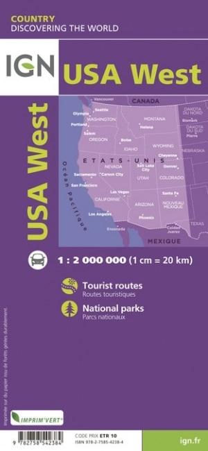
USA West IGN Folded Map
$19.95
Afterpay is only available for orders between $50.00 and $1000.00 More info
Detailed Road Coverage from Mexico to Canada
Folded Map | Scale 1:2,000,000
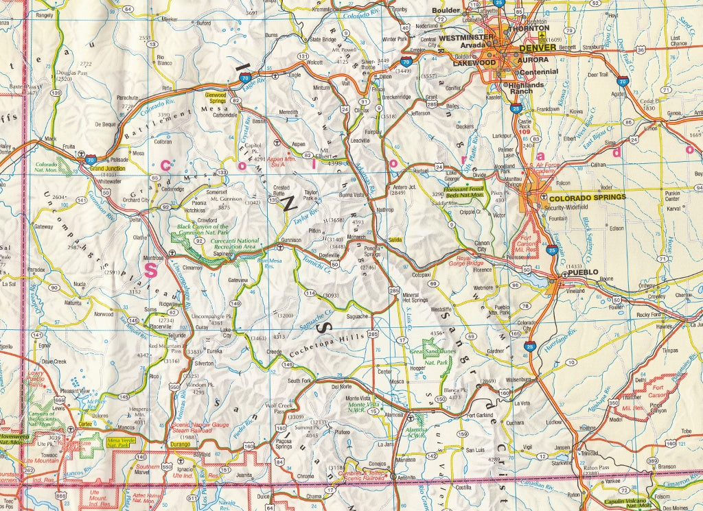
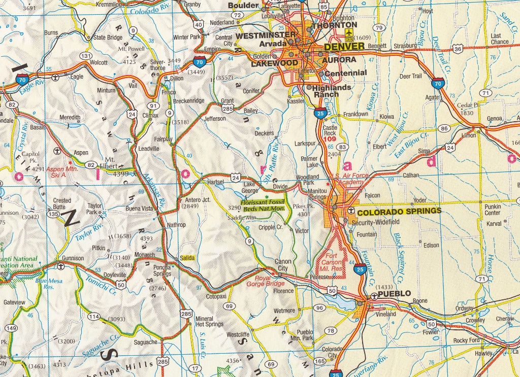
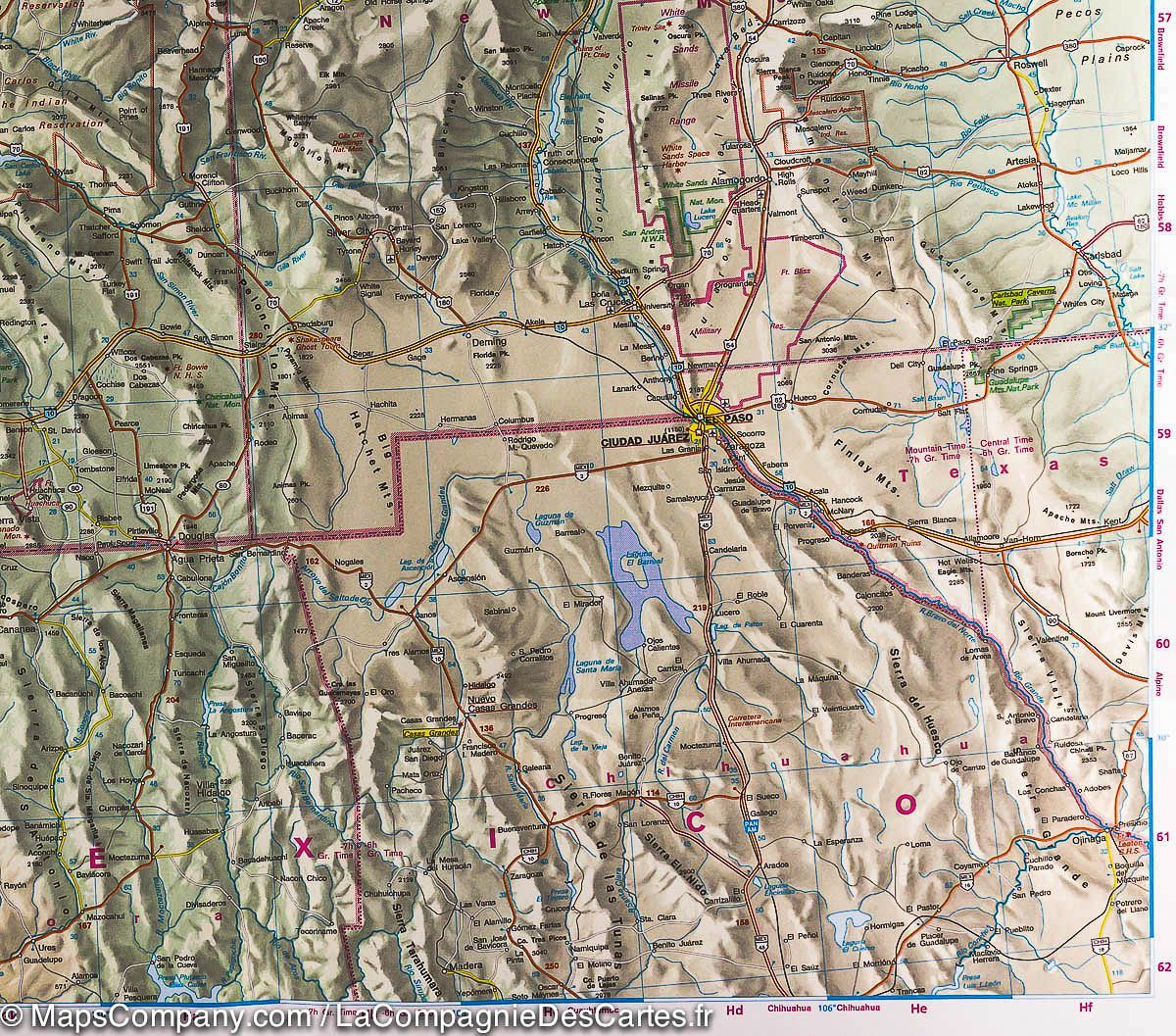
Explore the expansive western half of the United States with this high-quality folded road map from IGN (Institut Géographique National)—France’s national mapping authority renowned for cartographic precision.
Whether you're planning a road trip along the Pacific Coast, heading for the Grand Canyon, or venturing through Rocky Mountain territory, this map is the perfect companion for navigating the American West.
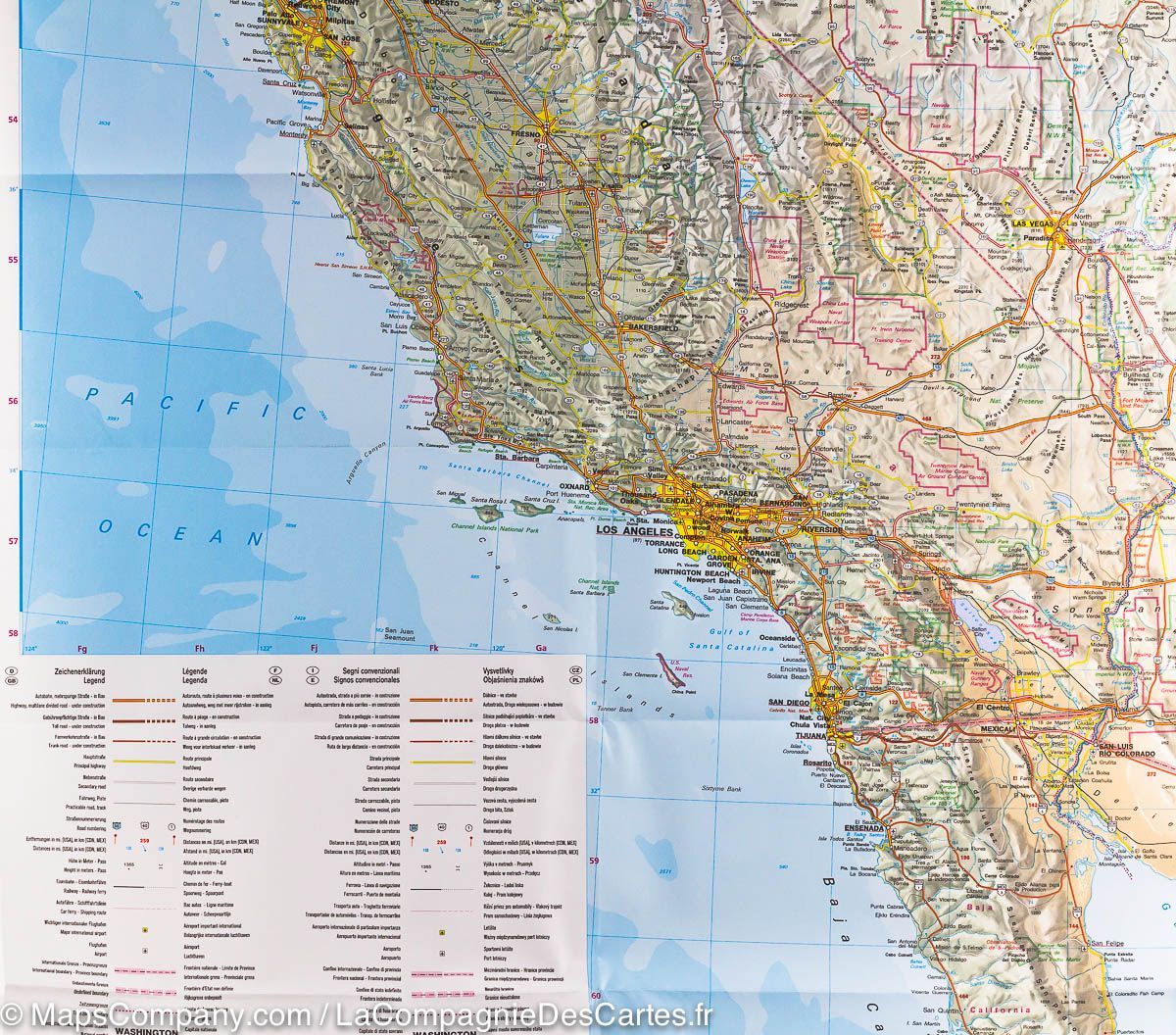
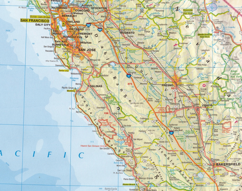
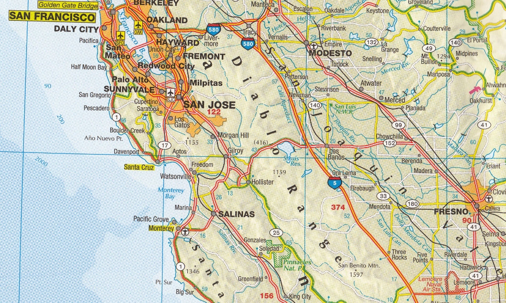
Extensive Geographic Coverage
This is one of the most comprehensive maps of the Western USA available in a portable folded format. It covers:
-
Southern USA, including parts of Texas, Arizona, and New Mexico
-
Extends northwards to the Canadian border, capturing Montana, Washington, and North Dakota
-
Includes California, Nevada, Utah, Colorado, Oregon, Idaho, and more
Perfectly scaled at 1:2,000,000, it strikes the ideal balance between broad coverage and legible detail.
Features & Highlights
-
Full road network, including:
-
Major highways, interstates, national and regional roads
-
Scenic byways and key transit corridors
-
-
Cities and towns clearly marked, from major metropolitan centres to remote townships
-
State boundaries and national parks outlined
-
Useful for route planning, backcountry navigation, or simply as a visual reference while travelling
Why Choose IGN?
IGN maps are known for their clean layout, precise detail, and durability. With decades of cartographic expertise, IGN produces international standard maps that are easy to read and trusted by travellers and professionals alike.
📐 Specifications
| Feature | Detail |
|---|---|
| Title | USA West Road Map |
| Publisher | IGN (Institut Géographique National) |
| Map Type | Folded, double-sided |
| Scale | 1:2,000,000 |
| Coverage Area | Southern border to Northern US, West Coast to the Rockies |
| Printed in | France |
Perfect For:
-
Road trippers exploring Route 66, the Pacific Coast Highway, or the Great American West
-
Outdoor adventurers heading into Yosemite, Yellowstone, or Zion
-
Educators and students looking for a broad reference map of the western U.S.
-
Visitors planning cross-border travel from Mexico to Canada
A practical and beautifully designed folded map for travellers who want to see it all—from deserts and canyons to mountains and coastlines.
Frequently Asked Questions
What area does the USA West IGN Folded Map cover?
The USA West IGN Folded Map provides road coverage of the region named in the product title. The map covers major cities, highways, towns, and regional roads, with inset city maps for key urban centres where applicable.
Is the USA West IGN Folded Map up to date?
Yes, this is the current edition. Mapworld stocks the most current editions from all major publishers, updated to reflect new roads and infrastructure.
What size is this map when unfolded?
Folded maps from Mapworld's range are compact and portable. Most standard folded road or travel maps open to between A1 (594 × 841mm) and A0 (841 × 1189mm) when fully unfolded, and fold down to approximately A4 or smaller for easy storage in a glove box, bag, or backpack.
Is the USA West IGN Folded Map in stock at Mapworld?
Mapworld maintains extensive stock across its map range and aims for fast dispatch. Orders placed before 2pm AEST on business days are typically dispatched the same day, with standard and express Australia-wide delivery options available.
Does Mapworld ship the USA West IGN Folded Map across Australia?
Yes, Mapworld ships Australia-wide. Standard shipping is a flat $7 rate, with free standard shipping on orders over $75. Express options are available at checkout. Most orders placed before 2pm AEST on weekdays are dispatched same day.
Related Items


© 2026 Mapworld. Website designed by Genie Media
X