- Australia ▾
- Topographic
▾
- Australia AUSTopo 250k (2024)
- Australia 50k Geoscience maps
- Australia 100k Geoscience maps
- Australia 250k Geoscience maps
- Australia 1.1m Geoscience maps
- New Zealand 50k maps
- New Zealand 250k maps
- New South Wales 25k maps
- New South Wales 50k maps
- New South Wales 100k maps
- Queensland 10k maps
- Queensland 25k maps
- Queensland 50k maps
- Queensland 100k maps
- Compasses
- Software
- GPS Systems
- Orienteering
- International ▾
- Wall Maps
▾
- World
- Australia & New Zealand
- Countries, Continents & Regions
- Historical
- Vintage National Geographic
- Australian Capital Territory
- New South Wales
- Northern Territory
- Queensland
- South Australia
- Tasmania
- Victoria
- Western Australia
- Celestial
- Children's
- Mining & Resources
- Wine Maps
- Healthcare
- Postcode Maps
- Electoral Maps
- Nautical ▾
- Flags
▾
- Australian Flag Sets & Banners
- Flag Bunting
- Handwavers
- Australian National Flags
- Aboriginal Flags
- Torres Strait Islander Flags
- International Flags
- Flagpoles & Accessories
- Australian Capital Territory Flags
- New South Wales Flags
- Northern Territory Flags
- Queensland Flags
- South Australia Flags
- Tasmania Flags
- Victoria Flags
- Western Australia Flags
- Gifts ▾
- Globes ▾
Dear valued customer. Please note that our checkout is not supported by old browsers. Please use a recent browser to access all checkout capabilities


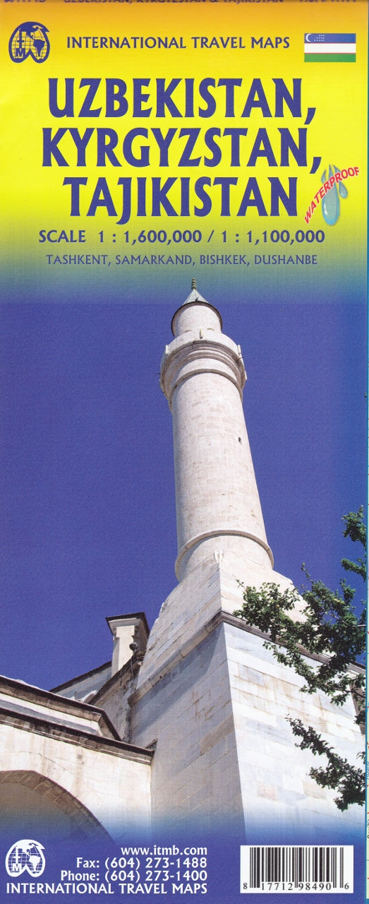
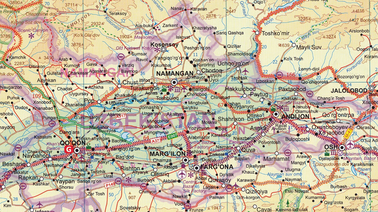
Uzbekistan,Tajikistan & Kyrgystan ITMB Map
$24.95
Afterpay is only available for orders between $50.00 and $1000.00 More info
Double-Sided Country Map | Scale: 1:350,000 / 1:1,100,000
Size: 690 mm × 1000 mm
🌏 Explore the Heart of Central Asia – Three Nations, One Map
This meticulously crafted map by International Travel Maps (ITMB) offers detailed coverage of three fascinating and culturally rich countries at the heart of Central Asia: Uzbekistan, Tajikistan, and Kyrgyzstan. It is a landmark in cartographic publishing, representing the first time these newly independent nations have been presented together in such depth and clarity on a standalone travel map.
Printed on both sides for maximum detail and usability, this map is an indispensable planning tool for travellers, researchers, and adventurers alike.
What’s Included
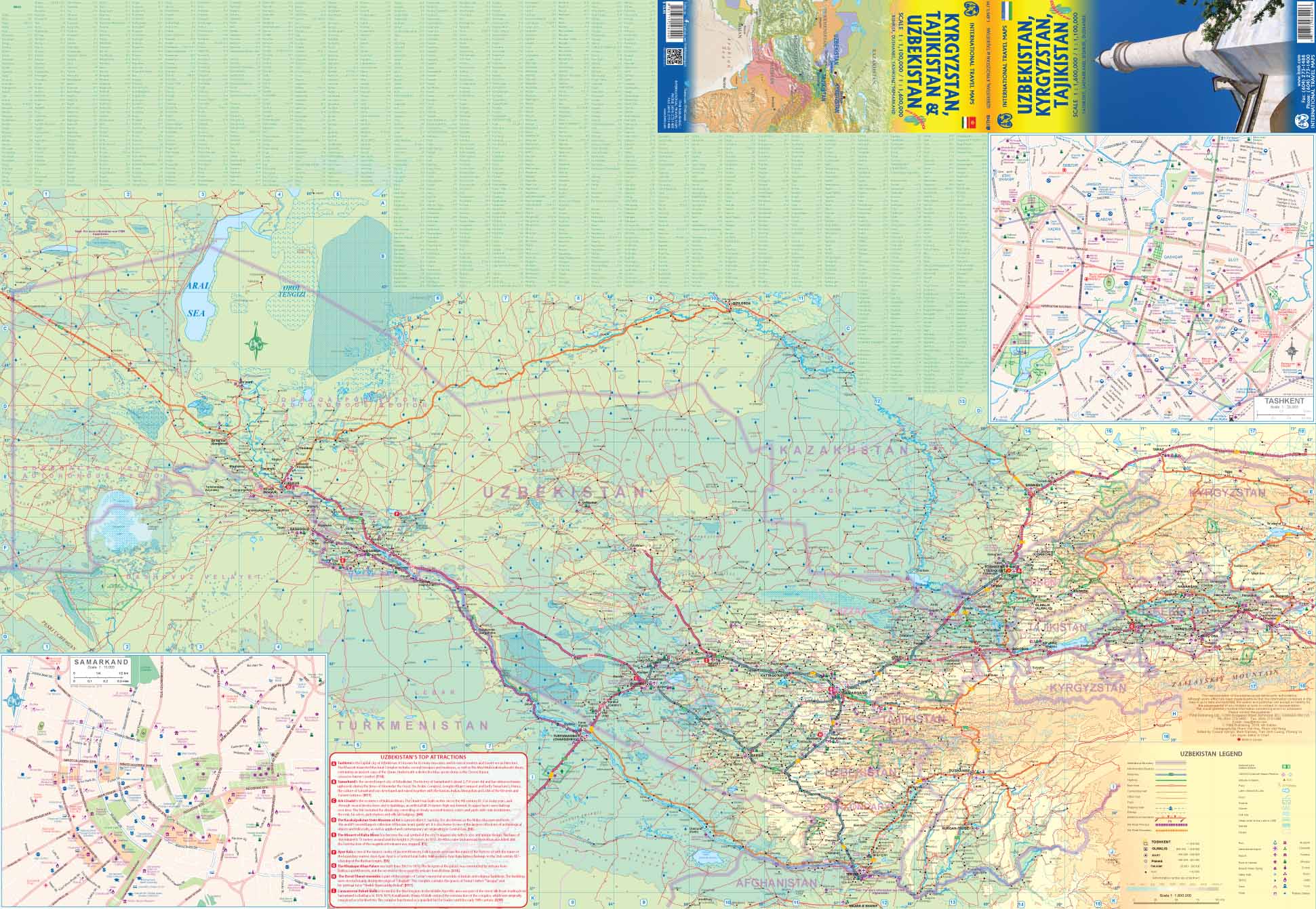
Side 1: Uzbekistan
-
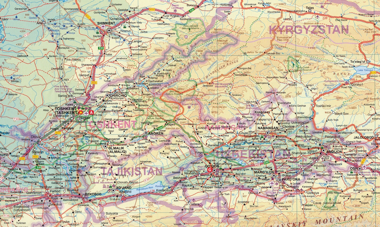
Coverage of the full country, including road networks, cities, and topographic detail
-
Excellent inset map of Tashkent, the vibrant Uzbek capital
-
Highlights historical cities like Samarkand, Bukhara, and Khiva
-
Road connections, airports, lakes, and rail lines clearly marked
-
Tourist icons for monuments, UNESCO World Heritage Sites, and key attractions
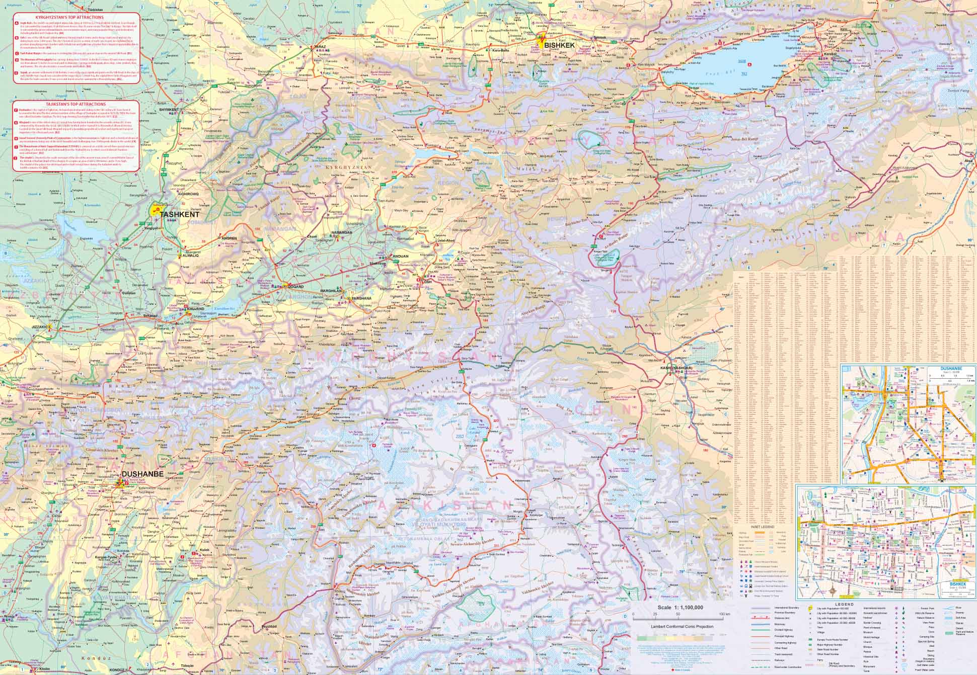
Side 2: Tajikistan & Kyrgyzstan
-
Full coverage of both nations, including remote mountain regions and major highways
-
Inset map of Bishkek, capital of Kyrgyzstan
-
Important towns, rivers, borders, and mountain passes marked
-
Includes part of the Pamir Highway, one of the world’s great overland routes
-
Borders with China, Pakistan, and Afghanistan are also shown for context
🏞️ Why This Map Stands Out
-
First-of-its-kind publication covering these countries in full detail as independent states
-
Ideal for overland travellers, cultural explorers, and expedition planners
-
Combines both political boundaries and natural terrain
-
Updated cartographic information reflecting modern infrastructure improvements
📐 Product Details
| Feature | Specification |
|---|---|
| Map Type | Folded, double-sided paper map |
| Publisher | International Travel Maps (ITMB) |
| Uzbekistan Scale | 1:350,000 |
| Tajikistan & Kyrgyzstan Scale | 1:1,100,000 |
| Size | 690 mm × 1000 mm |
| Edition | Most recent update |
🛡️ Optional Lamination Service
Upgrade your map to a laminated version for added protection and usability. Laminated maps are ideal for use with whiteboard markers and map dots, making them perfect for:
-
Travel planning
-
Classroom use
-
Fieldwork
-
Display in offices or libraries
Laminated maps are created by flattening the folded sheet and encapsulating it between two sheets of 80-micron gloss laminate. (Note: slight fold lines may still be visible due to the map’s original format.)
Perfect For:
-
Travellers planning routes through Central Asia
-
Educators and students studying the Silk Road, Soviet history, or modern geopolitics
-
Businesses working in logistics, energy, or regional development
-
Adventure seekers heading for the Tien Shan or Pamir Mountains
Discover a region few maps explore so well.
The Uzbekistan, Tajikistan & Kyrgyzstan ITMB Map opens a gateway to Central Asia with the detail, depth, and quality only ITMB can deliver.


