- Australia ▾
- Topographic
▾
- Australia AUSTopo 250k (2025)
- Australia 50k Geoscience maps
- Australia 100k Geoscience maps
- Australia 250k Geoscience maps
- Australia 1:1m Geoscience maps
- New Zealand 50k maps
- New Zealand 250k maps
- New South Wales 25k maps
- New South Wales 50k maps
- New South Wales 100k maps
- Queensland 10k maps
- Queensland 25k maps
- Queensland 50k maps
- Queensland 100k maps
- Western Australia 25k maps
- Western Australia 50k maps
- Western Australia 100k maps
- Compasses
- Software
- GPS Systems
- International ▾
- Wall Maps
▾
- World
- Australia & New Zealand
- Countries, Continents & Regions
- Historical
- Vintage National Geographic
- Australian Capital Territory
- New South Wales
- Northern Territory
- Queensland
- South Australia
- Tasmania
- Victoria
- Western Australia
- Celestial
- Children's
- Mining & Resources
- Wine Maps
- Healthcare
- Postcode Maps
- Electoral Maps
- Nautical ▾
- Flags
▾
- Australian Flag Sets & Banners
- Flag Bunting
- Handwavers
- Australian National Flags
- Aboriginal Flags
- Torres Strait Islander Flags
- International Flags
- Flagpoles & Accessories
- Australian Capital Territory Flags
- New South Wales Flags
- Northern Territory Flags
- Queensland Flags
- South Australia Flags
- Tasmania Flags
- Victoria Flags
- Western Australia Flags
- Gifts ▾
- Globes ▾
Dear valued customer. Please note that our checkout is not supported by old browsers. Please use a recent browser to access all checkout capabilities


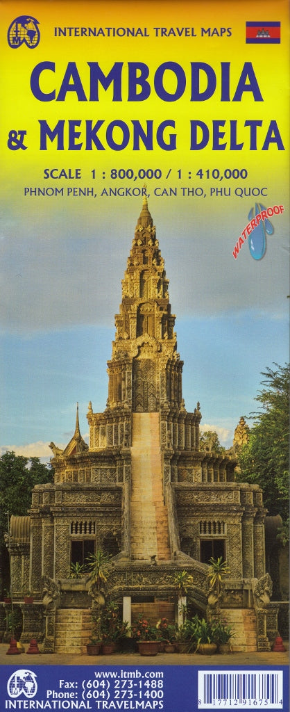
Cambodia & Mekong Delta ITMB Map
$24.95
Afterpay is only available for orders between $50.00 and $1000.00 More info
Scale: 1:410,000 (Cambodia) / 1:800,000 (Mekong Delta)
Size: 690 mm (W) x 1000 mm (H)
Format: Double-sided paper map (optional lamination available)
Publisher: International Travel Maps (ITMB)
Edition: Latest edition
🌏 Explore Two Countries on One Map: Cambodia & Vietnam’s Mekong Delta
This comprehensive double-sided travel map offers in-depth coverage of Cambodia and Vietnam’s Mekong Delta, making it the perfect companion for overland travellers, backpackers, educators, and cultural explorers. Whether you’re navigating ancient temples, floating villages, or bustling border towns, this map equips you with the accuracy and detail needed for confident travel.
🧭 Key Map Features
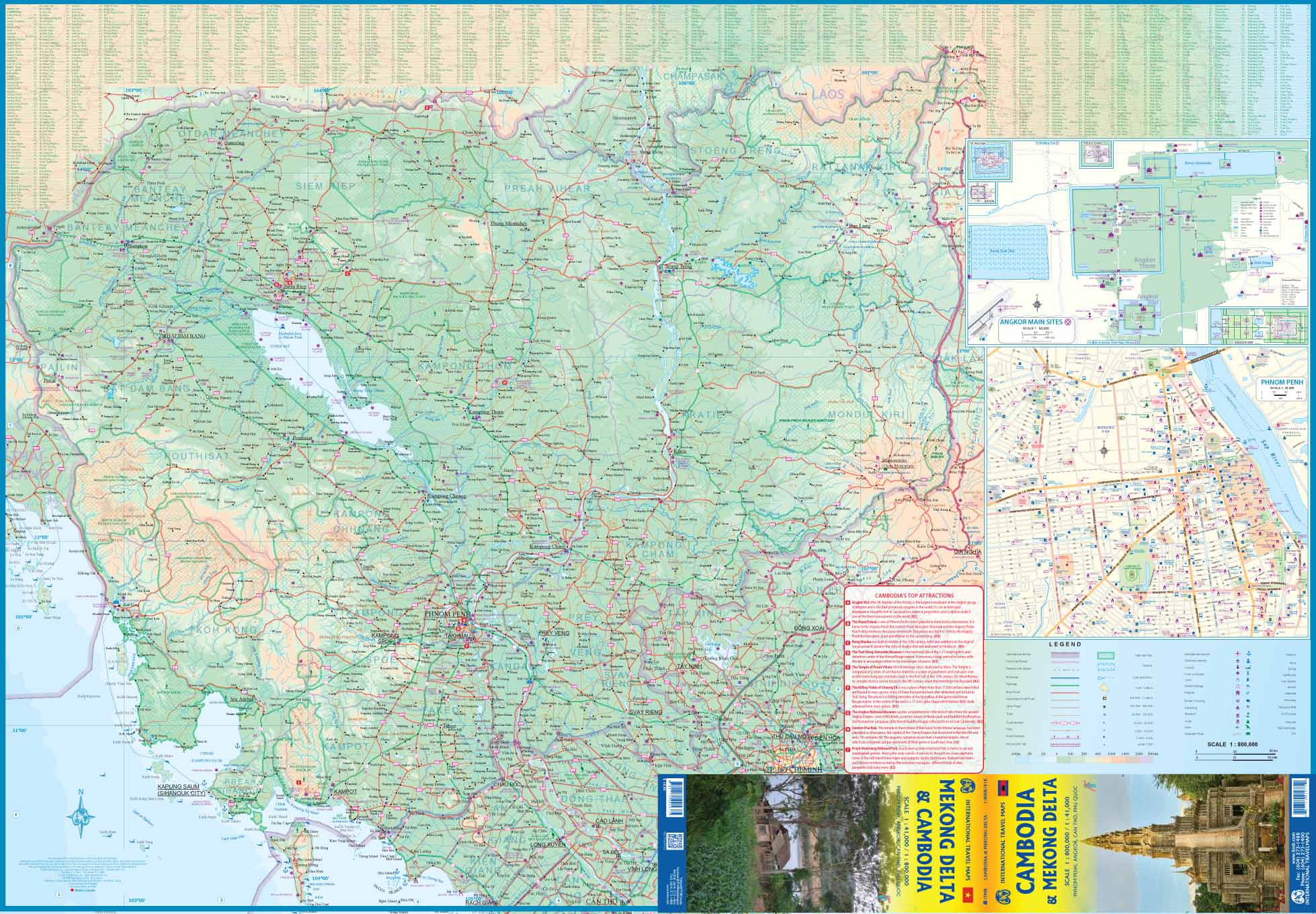
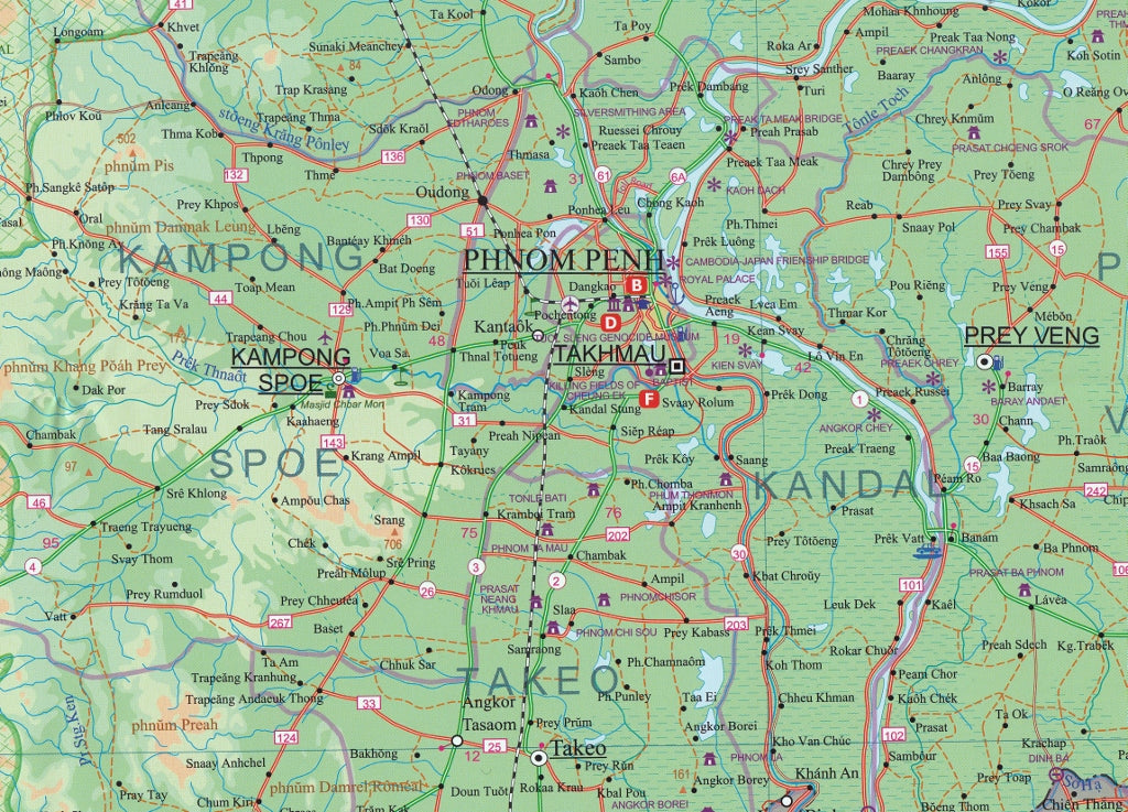
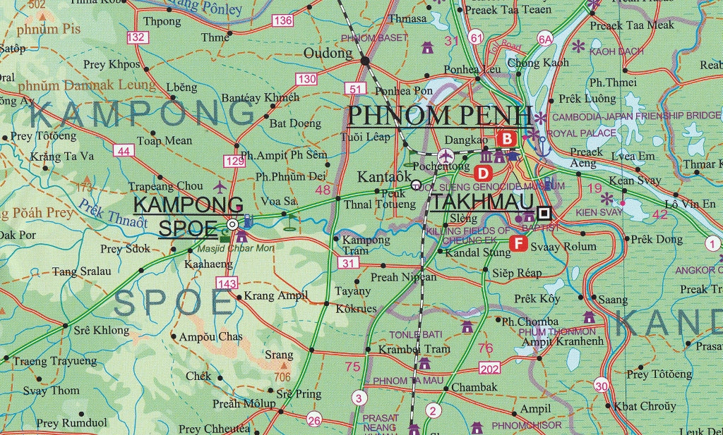
🧳 Side 1 – Cambodia (Scale 1:410,000)
-
Road and rail networks, including border crossings and ferry routes
-
National parks, rivers, lakes, and mountainous areas
-
Clearly marked provincial boundaries and regional capitals
-
Inset map of Phnom Penh with points of interest, transport routes, and key landmarks
-
Inset map of Angkor Main Sites, including Angkor Wat, Bayon, and Ta Prohm
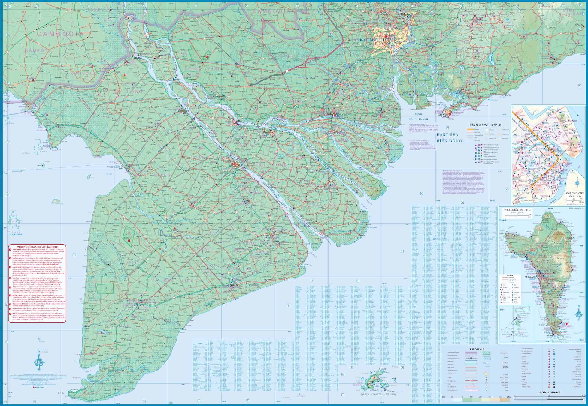
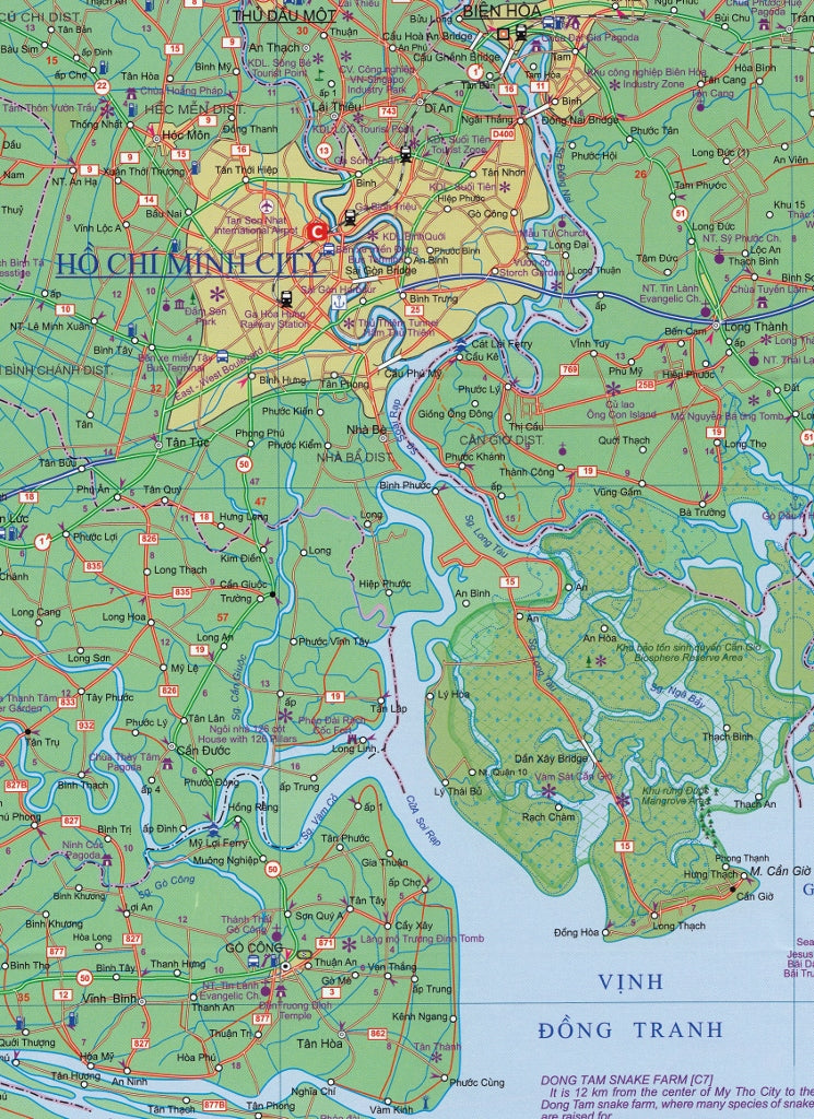
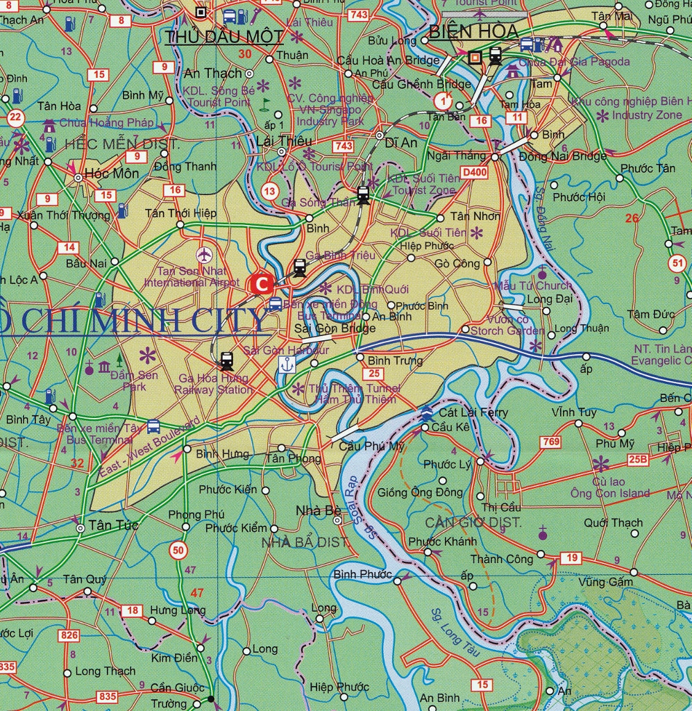
🌿 Side 2 – Mekong Delta, Vietnam (Scale 1:800,000)
-
Detailed mapping of the Mekong’s vast river network
-
Road access across provinces like An Giang, Dong Thap, and Vinh Long
-
Inset maps of:
-
Can Tho City – the economic and cultural heart of the Delta
-
Phu Quoc Island – known for pristine beaches and nature reserves
-
🗺️ Additional Details:
-
Extensive place name index for both countries
-
Tourist icons for cultural sites, temples, ruins, accommodations, transport hubs, and nature reserves
-
Ideal for planning regional travel itineraries and exploring both well-known and off-the-beaten-path destinations
♻️ Optional Lamination Upgrade
For rugged travellers, educators, and repeat use:
-
✅ Writeable surface – draw routes or highlight destinations with a whiteboard marker
-
✅ Waterproof and tear-resistant – perfect for tropical climates or fieldwork
-
✅ Durable construction – withstands folding, packing, and rough handling
Laminated maps are made by flattening and encapsulating the folded version in high-grade 80-micron laminate. Please note: minor fold lines may remain visible.
📌 Why Buy This Map?
| ✔ Feature | 🎯 Benefit |
|---|---|
| Covers two key regions | Plan seamlessly between Cambodia and southern Vietnam |
| Detailed insets | Zoom into hotspots like Angkor, Phnom Penh, and Can Tho |
| Cultural & geographical accuracy | Ideal for travellers, educators, and researchers |
| Compact and foldable | Easy to carry in a daypack or travel folder |
| Lamination option | Increases longevity and versatility on the road |
| Great value | Two maps in one – no need to purchase separate titles |
🌍 Who’s It For?
-
Adventure travellers exploring Cambodia and Vietnam overland
-
Cultural tourists visiting temples, ruins, and historical towns
-
Travel planners and tour operators needing cross-border navigation aids
-
Students and educators studying Southeast Asian geography or planning fieldwork
-
Gap year backpackers seeking a durable, all-in-one regional map
✅ Summary
The Cambodia & Mekong Delta ITMB Map is a versatile, travel-tested map designed for explorers who want more than just the basics. Whether you're tracing the temples of Angkor, cruising the Mekong, or navigating border crossings on a grand Indochina journey, this map is your essential guide.
Frequently Asked Questions
Where can I buy the Cambodia & Mekong Delta ITMB Map?
The Cambodia & Mekong Delta ITMB Map is available to buy online from Mapworld, Australia's largest map and geographic product retailer, with fast shipping Australia-wide.
Is the Cambodia & Mekong Delta ITMB Map in stock at Mapworld?
Mapworld maintains extensive stock across its map range and aims for fast dispatch. Orders placed before 2pm AEST on business days are typically dispatched the same day, with standard and express Australia-wide delivery options available.
What is Mapworld's returns policy?
Mapworld accepts returns on undamaged items in original condition. Contact Mapworld within 90 days of purchase to arrange a return or exchange.
Does Mapworld ship the Cambodia & Mekong Delta ITMB Map across Australia?
Yes, Mapworld ships Australia-wide. Standard shipping is a flat $7 rate, with free standard shipping on orders over $75. Express options are available at checkout. Most orders placed before 2pm AEST on weekdays are dispatched same day.
Related Items


© 2026 Mapworld. Website designed by Genie Media
X