- Australia ▾
- Topographic
▾
- Australia AUSTopo 250k (2025)
- Australia 50k Geoscience maps
- Australia 100k Geoscience maps
- Australia 250k Geoscience maps
- Australia 1:1m Geoscience maps
- New Zealand 50k maps
- New Zealand 250k maps
- New South Wales 25k maps
- New South Wales 50k maps
- New South Wales 100k maps
- Queensland 10k maps
- Queensland 25k maps
- Queensland 50k maps
- Queensland 100k maps
- Western Australia 25k maps
- Western Australia 50k maps
- Western Australia 100k maps
- Compasses
- Software
- GPS Systems
- International ▾
- Wall Maps
▾
- World
- Australia & New Zealand
- Countries, Continents & Regions
- Historical
- Vintage National Geographic
- Australian Capital Territory
- New South Wales
- Northern Territory
- Queensland
- South Australia
- Tasmania
- Victoria
- Western Australia
- Celestial
- Children's
- Mining & Resources
- Wine Maps
- Healthcare
- Postcode Maps
- Electoral Maps
- Nautical ▾
- Flags
▾
- Australian Flag Sets & Banners
- Flag Bunting
- Handwavers
- Australian National Flags
- Aboriginal Flags
- Torres Strait Islander Flags
- International Flags
- Flagpoles & Accessories
- Australian Capital Territory Flags
- New South Wales Flags
- Northern Territory Flags
- Queensland Flags
- South Australia Flags
- Tasmania Flags
- Victoria Flags
- Western Australia Flags
- Gifts ▾
- Globes ▾
Dear valued customer. Please note that our checkout is not supported by old browsers. Please use a recent browser to access all checkout capabilities


Chad ITMB Map
$24.95
Afterpay is only available for orders between $50.00 and $1000.00 More info
🇹🇩 Chad ITMB Folded Travel Map
Double-Sided | 1st Edition | Scale 1:1,500,000
Sheet Size: 680 mm (w) x 990 mm (h)
Optional Lamination Available
🗺️ Explore One of Africa's Least-Known Frontiers
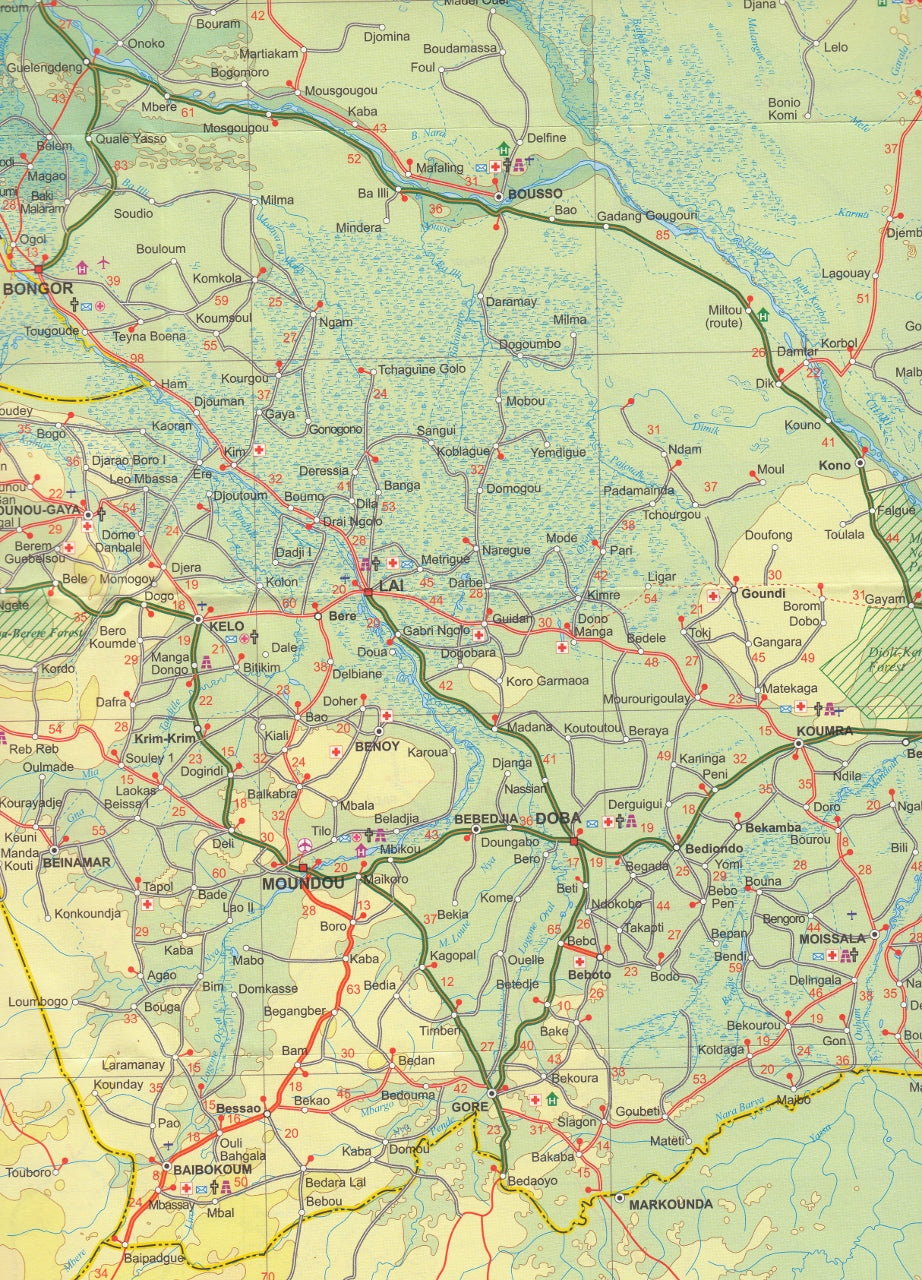
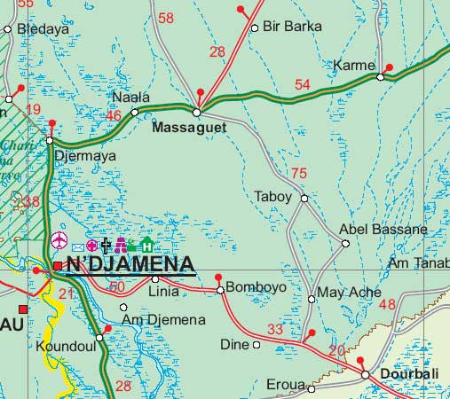
This highly detailed double-sided map of Chad from International Travel Maps (ITMB) offers an in-depth look at one of Central Africa's most geographically and historically fascinating countries. Once part of French Equatorial Africa, Chad boasts a rich cultural heritage and strategic wartime legacy. It served as the launch point for General Leclerc’s legendary Free French march across the Sahara to Tunisia during WWII.
Today, Chad continues to intrigue travelers with its vast desert landscapes, nomadic cultures, and the ever-shrinking Lake Chad—once one of the largest lakes on the continent.
🧭 Map Features
| 🗂️ Feature | 📍 Description |
|---|---|
| Scale | 1:1,500,000 – provides excellent detail while covering the entire country |
| Double-sided format | Maximizes legibility and includes expanded cartographic data |
| Inset Map | Detailed city inset of N'Djamena, Chad's capital and largest city |
| Topographical Detail | Shows elevation, rivers, lakes (including Lake Chad), and desert regions |
| Road Network | Shows national highways, secondary roads, and tracks for overland travel |
| Points of Interest | Cultural landmarks, towns, regional boundaries, borders and more |
💡 Why Buy This Map?
-
✅ Essential for travellers, researchers, and aid workers heading into remote areas of Chad
-
✅ Covers an under-mapped region with valuable on-the-ground travel information
-
✅ Ideal for educational use, NGOs, and those working in humanitarian logistics or geopolitics
-
✅ Historically rich – learn about the WWII-era routes and the region’s colonial past
-
✅ Includes detailed capital city inset of N’Djamena for local navigation
🛡️ Optional Lamination Upgrade
We can supply this map fully laminated with a tough, glossy finish:
-
🖊️ Draw on it with whiteboard markers or apply map dots without leaving permanent marks
-
💧 Water-resistant and tear-proof – ideal for field work or rough travel
-
♻️ Encapsulated in two sheets of 80-micron laminate after being carefully flattened – please note that original fold lines may still be faintly visible
📦 Specifications
| Specification | Details |
|---|---|
| Publisher | International Travel Maps (ITMB) |
| Edition | Latest edition (see product options) |
| Format | Folded map (laminated or paper) |
| Printed on | Durable, high-quality stock |
| Unfolded Size | 680 mm (w) x 990 mm (h) |
| Scale | 1:1,500,000 |
| Language | English |
🌍 Ideal For:
-
✈️ Adventure travellers and expedition planners
-
🏕️ Overlanders exploring the Sahara and Sahel
-
📚 Academics and students of geography, history, or African studies
-
🏢 NGOs and humanitarian logistics teams
-
🧭 Cartography collectors seeking rare regional maps
Note: This is an order-on-demand item. Please allow up to 10 working days for delivery.
Frequently Asked Questions
Where can I buy the Chad ITMB Map?
The Chad ITMB Map is available to buy online from Mapworld, Australia's largest map and geographic product retailer, with fast shipping Australia-wide.
Is the Chad ITMB Map in stock at Mapworld?
Mapworld maintains extensive stock across its map range and aims for fast dispatch. Orders placed before 2pm AEST on business days are typically dispatched the same day, with standard and express Australia-wide delivery options available.
What is Mapworld's returns policy?
Mapworld accepts returns on undamaged items in original condition. Contact Mapworld within 90 days of purchase to arrange a return or exchange.
Does Mapworld ship the Chad ITMB Map across Australia?
Yes, Mapworld ships Australia-wide. Standard shipping is a flat $7 rate, with free standard shipping on orders over $75. Express options are available at checkout. Most orders placed before 2pm AEST on weekdays are dispatched same day.
Related Items


© 2026 Mapworld. Website designed by Genie Media
X