- Australia ▾
- Topographic
▾
- Australia AUSTopo 250k (2025)
- Australia 50k Geoscience maps
- Australia 100k Geoscience maps
- Australia 250k Geoscience maps
- Australia 1:1m Geoscience maps
- New Zealand 50k maps
- New Zealand 250k maps
- New South Wales 25k maps
- New South Wales 50k maps
- New South Wales 100k maps
- Queensland 10k maps
- Queensland 25k maps
- Queensland 50k maps
- Queensland 100k maps
- Western Australia 25k maps
- Western Australia 50k maps
- Western Australia 100k maps
- Compasses
- Software
- GPS Systems
- International ▾
- Wall Maps
▾
- World
- Australia & New Zealand
- Countries, Continents & Regions
- Historical
- Vintage National Geographic
- Australian Capital Territory
- New South Wales
- Northern Territory
- Queensland
- South Australia
- Tasmania
- Victoria
- Western Australia
- Celestial
- Children's
- Mining & Resources
- Wine Maps
- Healthcare
- Postcode Maps
- Electoral Maps
- Nautical ▾
- Flags
▾
- Australian Flag Sets & Banners
- Flag Bunting
- Handwavers
- Australian National Flags
- Aboriginal Flags
- Torres Strait Islander Flags
- International Flags
- Flagpoles & Accessories
- Australian Capital Territory Flags
- New South Wales Flags
- Northern Territory Flags
- Queensland Flags
- South Australia Flags
- Tasmania Flags
- Victoria Flags
- Western Australia Flags
- Gifts ▾
- Globes ▾
Dear valued customer. Please note that our checkout is not supported by old browsers. Please use a recent browser to access all checkout capabilities


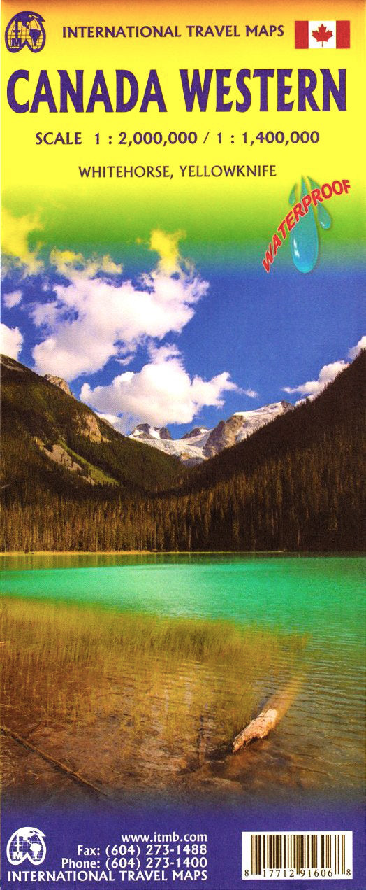
Canada Western ITMB Map
$24.95
Afterpay is only available for orders between $50.00 and $1000.00 More info
🏔️ Western Canada ITMB Map – 3rd Edition
British Columbia, Alberta & Yukon + Road Network in the Northwest Territories
Scale: 1:1,400,000 / 1:2,000,000
Map Size: 690 mm x 990 mm
🌲 A Vast & Rugged Landscape, Mapped with Precision
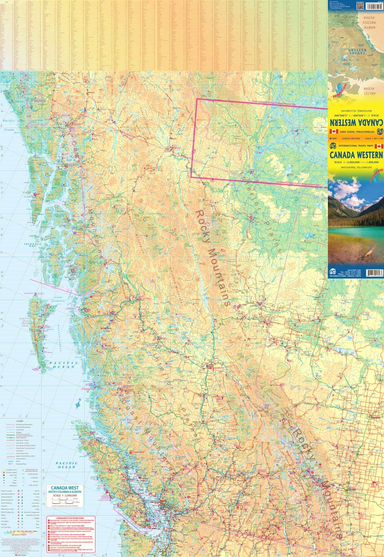
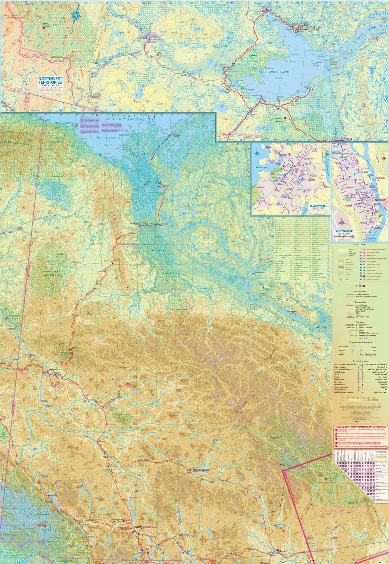
The Western Canada ITMB Map offers a detailed cartographic portrait of one of the most geographically spectacular regions in the world. From the windswept Pacific coastline of British Columbia to the high alpine passes of Alberta’s Rockies and the untamed wilderness of the Yukon, this double-sided map provides extensive coverage of Canada’s western frontier—one of the most remote and beautiful travel regions on the planet.
This edition is a completely reworked and digitally updated map, with significantly improved scale and clarity compared to earlier releases. It represents British Columbia, Alberta, and the Yukon Territory at 1:1,400,000, while the road-accessible portion of the Northwest Territories is included at 1:2,000,000. This is a practical solution for travelers exploring real-world routes across some of the most remote drivable terrain in North America.
🧭 Key Features
-
Double-sided map design:
-
Side A: British Columbia & Alberta
-
Side B: Yukon & road-accessible Northwest Territories
-
-
Extensive road coverage:
-
All major highways, paved and unpaved secondary roads, ferry routes, scenic byways
-
Winter roads and routes under construction (e.g. north of Inuvik)
-
-
Clear topographical shading:
-
Mountains, rivers, lakes, national parks, and geographic features easily identifiable
-
-
Urban and rural detail:
-
Cities, towns, and remote settlements labeled with legible type
-
Indigenous reserves and important landmarks included
-
-
Updated ferry crossings and tourism routes:
-
Includes key access points for road trippers and overlanders exploring the Alaska Highway, Icefields Parkway, and Cassiar Highway
-
📏 Specifications
| Attribute | Details |
|---|---|
| Publisher | ITMB Publishing |
| Edition | 3rd Edition |
| Scale | 1:1,400,000 (BC/Alberta/Yukon) 1:2,000,000 (NWT) |
| Map Size | 690 mm x 990 mm |
| Format | Double-sided, folded map |
| Optional | Available laminated for durability |
Why Buy This Map?
| ✅ Feature | 🌟 Benefit |
|---|---|
| 📍 Focused regional coverage | Ideal for travelers focusing on Western Canada’s best-known provinces |
| 🧭 Updated and precise scale | Better detail than older pan-Canada maps; easy navigation and planning |
| ❄️ Winter road notations | Includes roads under development like the all-season Arctic Ocean route |
| 🚐 Perfect for overlanders & RVers | Highlights driveable terrain from Vancouver to the tundra |
| 🧳 Folded or laminated | Choose a format that suits your travel style — folded for compact storage, laminated for durability and planning |
| 🌍 Off-the-beaten-path explorer tool | Get insight into vast, remote territories beyond tourist brochures |
Who's This Map For?
-
🚗 Overland adventurers exploring routes from the Rockies to the Arctic
-
🏕️ Road trippers & vanlifers seeking wilderness detours and national parks
-
📚 Teachers and students of geography or Canadian regional studies
-
✈️ Visitors and expats unfamiliar with the vast distances and unique road systems of Western Canada
-
📌 Planners and navigators looking for a real-world, practical map of this immense region
Laminated Option Available
Want to make notes, draw routes, or apply map dots without leaving marks? Opt for our laminated version, which features:
-
Write-on/wipe-off surface (compatible with whiteboard markers)
-
Protection from spills, stains, and tears
-
Flattened and encapsulated, but note that original fold lines may remain slightly visible due to the folding process
This map provides the real-world clarity and scale you need to truly understand the epic size and scope of Canada’s western wilderness. Whether you’re planning a trip from Vancouver to Dawson City, researching the Icefields Parkway, or dreaming of driving from the Arctic Ocean to the Panama Canal — this map is a must-have.
🛒 Order your copy today and explore Canada’s wild west with confidence.
Frequently Asked Questions
Where can I buy the Canada Western ITMB Map?
The Canada Western ITMB Map is available to buy online from Mapworld, Australia's largest map and geographic product retailer, with fast shipping Australia-wide.
Is the Canada Western ITMB Map in stock at Mapworld?
Mapworld maintains extensive stock across its map range and aims for fast dispatch. Orders placed before 2pm AEST on business days are typically dispatched the same day, with standard and express Australia-wide delivery options available.
What is Mapworld's returns policy?
Mapworld accepts returns on undamaged items in original condition. Contact Mapworld within 90 days of purchase to arrange a return or exchange.
Does Mapworld ship the Canada Western ITMB Map across Australia?
Yes, Mapworld ships Australia-wide. Standard shipping is a flat $7 rate, with free standard shipping on orders over $75. Express options are available at checkout. Most orders placed before 2pm AEST on weekdays are dispatched same day.
Related Items


© 2026 Mapworld. Website designed by Genie Media
X