- Australia ▾
- Topographic
▾
- Australia AUSTopo 250k (2025)
- Australia 50k Geoscience maps
- Australia 100k Geoscience maps
- Australia 250k Geoscience maps
- Australia 1:1m Geoscience maps
- New Zealand 50k maps
- New Zealand 250k maps
- New South Wales 25k maps
- New South Wales 50k maps
- New South Wales 100k maps
- Queensland 10k maps
- Queensland 25k maps
- Queensland 50k maps
- Queensland 100k maps
- Western Australia 25k maps
- Western Australia 50k maps
- Western Australia 100k maps
- Compasses
- Software
- GPS Systems
- International ▾
- Wall Maps
▾
- World
- Australia & New Zealand
- Countries, Continents & Regions
- Historical
- Vintage National Geographic
- Australian Capital Territory
- New South Wales
- Northern Territory
- Queensland
- South Australia
- Tasmania
- Victoria
- Western Australia
- Celestial
- Children's
- Mining & Resources
- Wine Maps
- Healthcare
- Postcode Maps
- Electoral Maps
- Nautical ▾
- Flags
▾
- Australian Flag Sets & Banners
- Flag Bunting
- Handwavers
- Australian National Flags
- Aboriginal Flags
- Torres Strait Islander Flags
- International Flags
- Flagpoles & Accessories
- Australian Capital Territory Flags
- New South Wales Flags
- Northern Territory Flags
- Queensland Flags
- South Australia Flags
- Tasmania Flags
- Victoria Flags
- Western Australia Flags
- Gifts ▾
- Globes ▾
Dear valued customer. Please note that our checkout is not supported by old browsers. Please use a recent browser to access all checkout capabilities


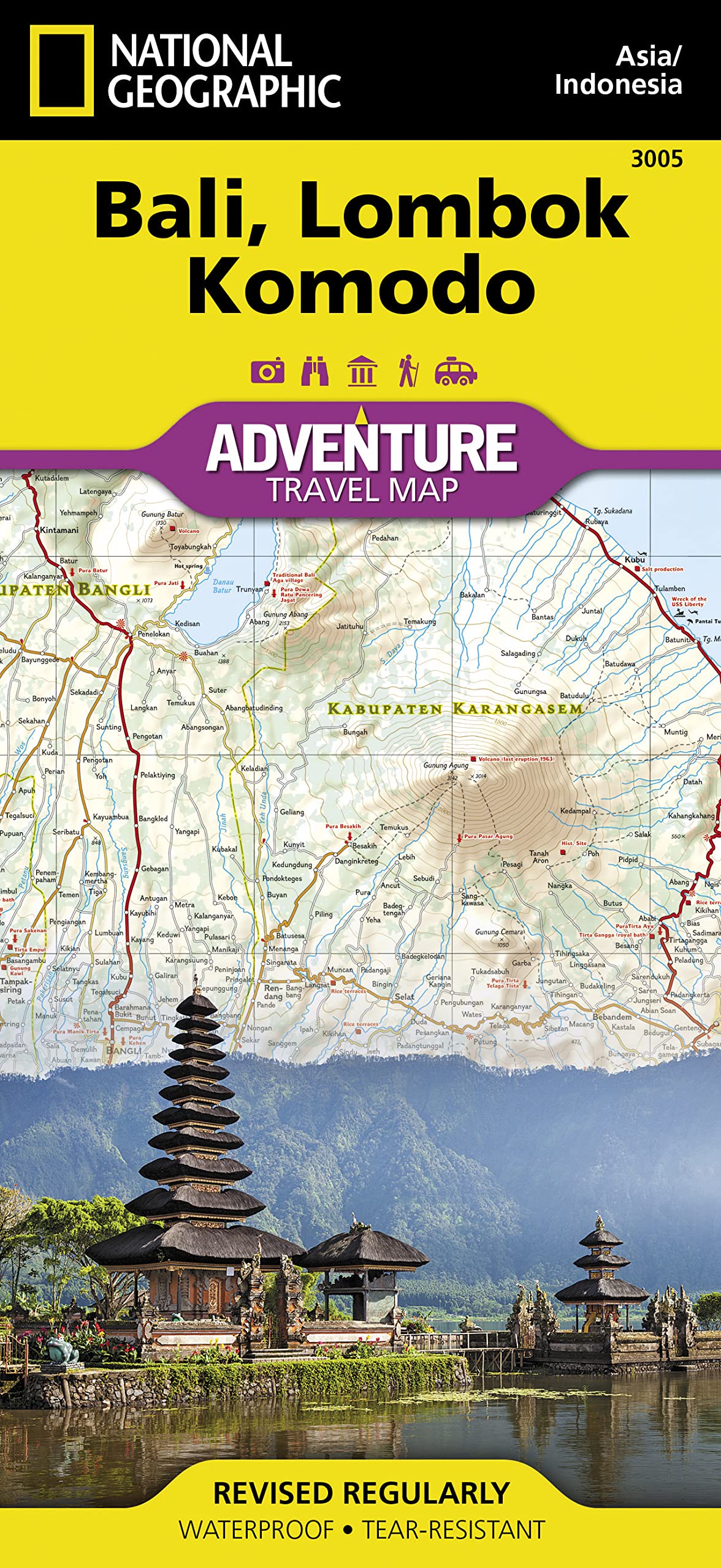
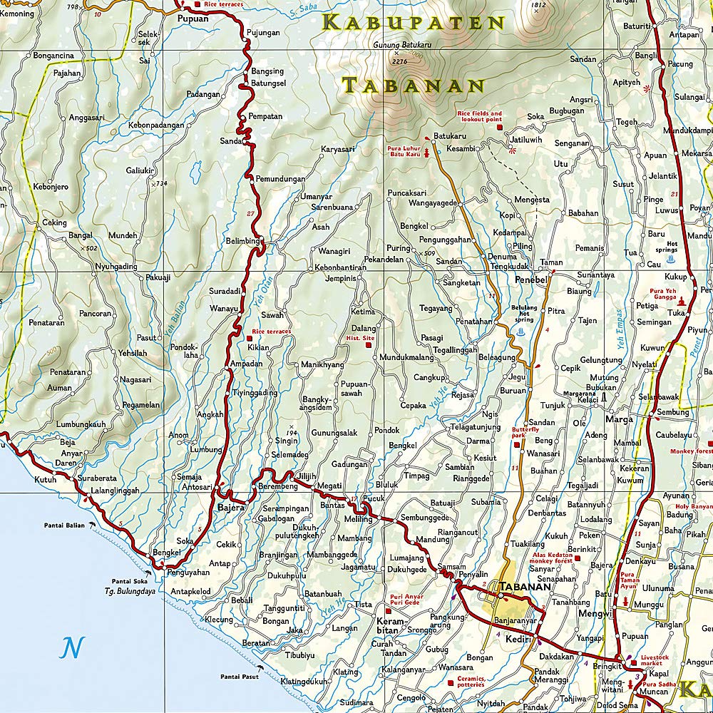
Bali Lombok Komodo National Geographic Folded Map
$27.95
Afterpay is only available for orders between $50.00 and $1000.00 More info
Explore Indonesia’s Island Paradise — From Volcanic Peaks to Coral Reefs
Unveil the wonder of Indonesia’s most iconic islands with the National Geographic Bali, Lombok & Komodo Adventure Map — the perfect companion for travellers, adventurers, and nature lovers seeking to discover this diverse archipelago. From the lush rice terraces of Bali to the volcanic spine of Lombok and the dragon-haunted hills of Komodo, this map is your essential guide to some of Southeast Asia’s most compelling landscapes.
Expertly designed for intrepid explorers and casual tourists alike, this waterproof map offers comprehensive travel detail, vibrant topography, and practical insight for every corner of your journey.
🌟 Key Features & Benefits
| ✅ | Why This Map Stands Out |
|---|---|
| 🌋 | Detailed topographic mapping of Bali, Lombok, Komodo & Nusa Penida |
| 🐉 | Explore Komodo National Park, home of the world-famous Komodo dragons |
| 🛣️ | Includes highways, roads, minor tracks, and walking trails |
| 📍 | Highlights UNESCO sites, temples, dive spots, surfing beaches, harbours, and ferry routes |
| 🧭 | Features airports, anchorages, boat routes & visitor centres |
| 💧 | Printed on durable synthetic paper – waterproof, tear-resistant, built for travel |
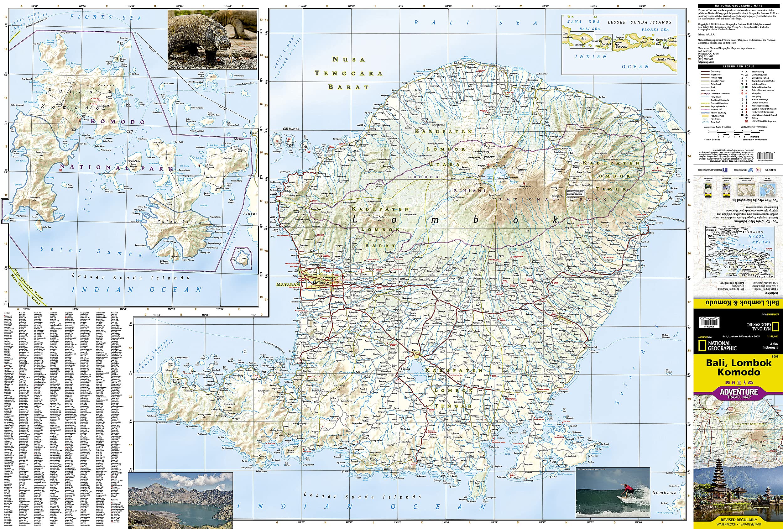
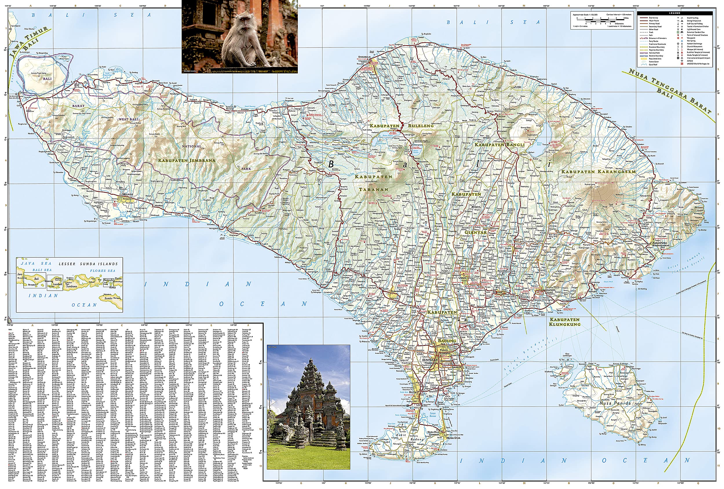
🏝️ Coverage Overview
-
Front Side:
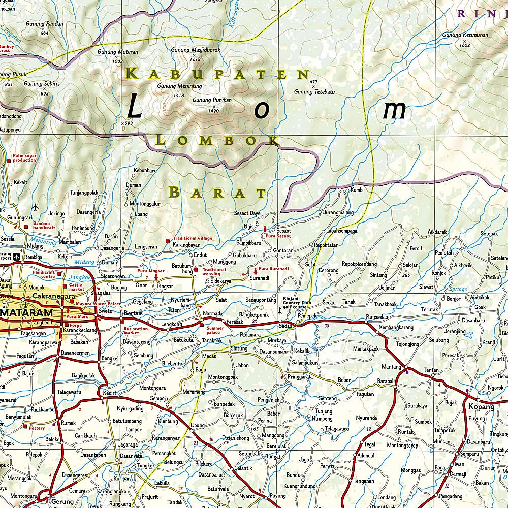
Covers Lombok and Komodo, including coastal roads, mountain tracks, ports, and dive sites.
National parks and remote villages are clearly marked, making this side ideal for outdoor exploration. -
Reverse Side:
Features Bali and Nusa Penida in high detail.
Shows major tourist centres like Ubud, Kuta, Seminyak, Sanur, and Nusa Dua, along with religious landmarks, scenic routes, and hiking trails. -
Inset Map:
A helpful overview of the Lesser Sunda Islands shows the relative location of Bali, Lombok, and Komodo within the wider archipelago.
📌 Points of Interest Included
-
🌿 UNESCO World Heritage Sites
-
🏖️ Major beaches and surfing areas
-
🤿 Diving and snorkelling locations
-
🕌 Temples, religious and cultural landmarks
-
🏞️ National parks and protected zones
-
🛳️ Ferry terminals, traditional boat routes, airports and airfields
-
🧭 Tourist information centres for in-country assistance
📐 Specifications
| Specification | Details |
|---|---|
| Map Format | Folded adventure map |
| Material | Synthetic waterproof, tear-resistant paper |
| Map Scale | 1:155,000 |
| Sheet Size | 37.75" x 25.5" (96 cm x 65 cm) |
| Folded Size | 4.25" x 9.25" (10.8 cm x 23.5 cm) |
| Publisher | National Geographic Maps |
| Map Edition | Latest available |
| ISBN | Available upon request |
🌏 Ideal For:
-
🧘 Yoga and wellness seekers in Ubud
-
🌋 Volcano hikers heading to Mt. Rinjani or Batur
-
🏝️ Island hoppers exploring the Gili Islands and Nusa Penida
-
🐉 Wildlife lovers visiting Komodo National Park
-
🧳 Independent travellers, tour planners, and researchers
-
🤿 Divers, surfers, trekkers, and eco-tourists
✈️ Built for Real-World Travel
Unlike flimsy paper maps that tear in your backpack, this Adventure Map is printed on tough synthetic material. It’s waterproof, rip-resistant, and folds down compactly – perfect for your backpack, glovebox, or travel binder.
Whether you're planning your journey or navigating it in the field, this map is designed to go the distance with you.
🛒 Add it to your travel kit today — your Indonesian adventure starts here.
Frequently Asked Questions
What area does the Bali Lombok Komodo National Geographic Folded Map cover?
The Bali Lombok Komodo National Geographic Folded Map provides road coverage of the region named in the product title. The map covers major cities, highways, towns, and regional roads, with inset city maps for key urban centres where applicable.
Is the Bali Lombok Komodo National Geographic Folded Map up to date?
Yes, this is the current edition. Mapworld stocks the most current editions from all major publishers, updated to reflect new roads and infrastructure.
What size is this map when unfolded?
Folded maps from Mapworld's range are compact and portable. Most standard folded road or travel maps open to between A1 (594 × 841mm) and A0 (841 × 1189mm) when fully unfolded, and fold down to approximately A4 or smaller for easy storage in a glove box, bag, or backpack.
Is the Bali Lombok Komodo National Geographic Folded Map in stock at Mapworld?
Mapworld maintains extensive stock across its map range and aims for fast dispatch. Orders placed before 2pm AEST on business days are typically dispatched the same day, with standard and express Australia-wide delivery options available.
Does Mapworld ship the Bali Lombok Komodo National Geographic Folded Map across Australia?
Yes, Mapworld ships Australia-wide. Standard shipping is a flat $7 rate, with free standard shipping on orders over $75. Express options are available at checkout. Most orders placed before 2pm AEST on weekdays are dispatched same day.
Related Items


© 2026 Mapworld. Website designed by Genie Media
X