- Australia ▾
- Topographic
▾
- Australia AUSTopo 250k (2025)
- Australia 50k Geoscience maps
- Australia 100k Geoscience maps
- Australia 250k Geoscience maps
- Australia 1:1m Geoscience maps
- New Zealand 50k maps
- New Zealand 250k maps
- New South Wales 25k maps
- New South Wales 50k maps
- New South Wales 100k maps
- Queensland 10k maps
- Queensland 25k maps
- Queensland 50k maps
- Queensland 100k maps
- Western Australia 25k maps
- Western Australia 50k maps
- Western Australia 100k maps
- Compasses
- Software
- GPS Systems
- International ▾
- Wall Maps
▾
- World
- Australia & New Zealand
- Countries, Continents & Regions
- Historical
- Vintage National Geographic
- Australian Capital Territory
- New South Wales
- Northern Territory
- Queensland
- South Australia
- Tasmania
- Victoria
- Western Australia
- Celestial
- Children's
- Mining & Resources
- Wine Maps
- Healthcare
- Postcode Maps
- Electoral Maps
- Nautical ▾
- Flags
▾
- Australian Flag Sets & Banners
- Flag Bunting
- Handwavers
- Australian National Flags
- Aboriginal Flags
- Torres Strait Islander Flags
- International Flags
- Flagpoles & Accessories
- Australian Capital Territory Flags
- New South Wales Flags
- Northern Territory Flags
- Queensland Flags
- South Australia Flags
- Tasmania Flags
- Victoria Flags
- Western Australia Flags
- Gifts ▾
- Globes ▾
Dear valued customer. Please note that our checkout is not supported by old browsers. Please use a recent browser to access all checkout capabilities


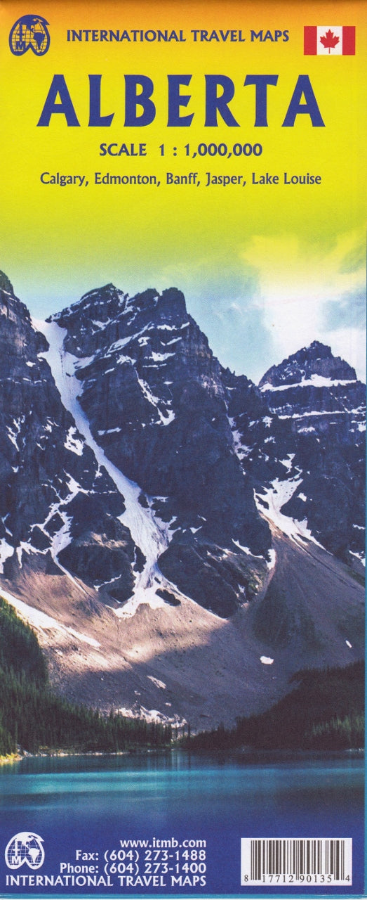
Alberta ITMB Map
$24.95
Afterpay is only available for orders between $50.00 and $1000.00 More info
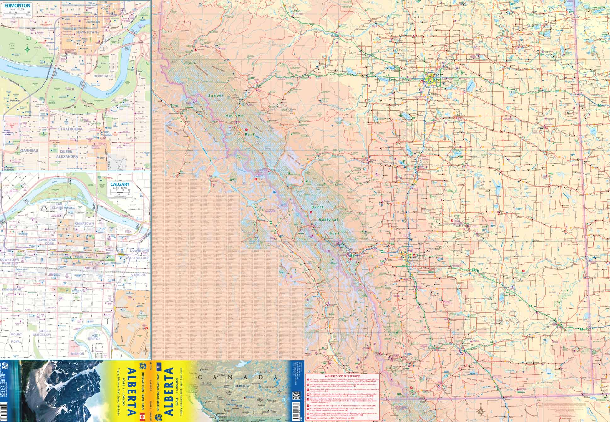
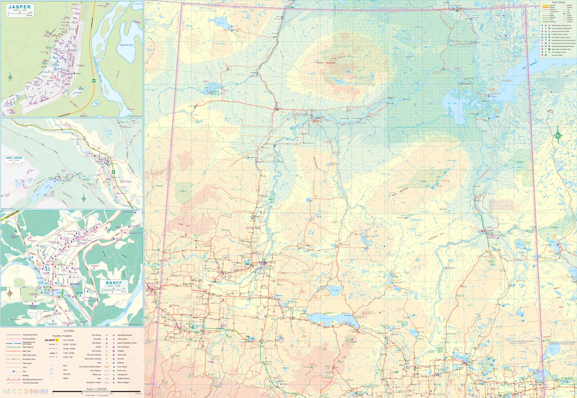
Scale: 1:1,000,000 | Size: 685 mm x 990 mm | Double-Sided | Optional Lamination
Explore the Wild Beauty of Western Canada
From the soaring peaks of the Rockies to the rolling prairies and ancient badlands, Alberta is one of Canada’s most iconic and diverse provinces. This double-sided Alberta Travel Map by ITMB (International Travel Maps) is your comprehensive guide to the province’s rugged wilderness, national parks, historic landmarks, and dynamic cities.
Whether you're venturing into Banff and Jasper, tracing dinosaur fossils in Drumheller, or road-tripping between Calgary and Edmonton, this map offers the accuracy, clarity, and scope you need for confident navigation.
🗺️ Map Highlights
| Feature | Description |
|---|---|
| Scale | 1:1,000,000 – ideal for regional planning and road trips |
| Format | Double-sided map – maximising coverage and detail |
| Coverage | Entire province of Alberta, from the Rockies to the prairies |
| Cities & Towns | Includes Calgary, Edmonton, Red Deer, Lethbridge, Medicine Hat, and more |
| Natural Attractions | Banff & Jasper National Parks, Lake Louise, Waterton Lakes, and Kananaskis |
| Historic Sites | Head-Smashed-In Buffalo Jump, Drumheller Badlands, fossil beds |
| Tourist Features | Scenic drives, parks, museums, heritage routes, and more |
| Topography | Rivers, lakes, elevation shading, and natural reserves |
🌟 Why Choose This Map?
✔️ Made for Explorers – From world-class ski resorts to quiet backroads, this map covers it all.
✔️ Tourist-Friendly – Highlights key attractions, road networks, and recreational opportunities.
✔️ Updated Road Detail – Includes major highways, regional roads, and distances between towns.
✔️ Compact and Informative – A great balance of detail and usability for both planning and on-the-go reference.
🧼 Optional Laminated Finish
Upgrade your map for durability and reusability:
🛡️ Encapsulated in twin 80-micron gloss laminate, our laminated version is:
-
Waterproof and tear-resistant
-
Writable with whiteboard markers (great for trip planning)
-
Compatible with our removable Map Dots
-
UV-protected to resist fading
📌 Note: The laminated version is produced by flattening the folded map and sealing it. Slight fold lines may still be visible beneath the laminate.
📐 Product Specifications
| Attribute | Detail |
|---|---|
| Title | Alberta Travel Map – ITMB |
| Publisher | International Travel Maps (Canada) |
| Scale | 1:1,000,000 |
| Dimensions | 685 mm (W) x 990 mm (H) |
| Format | Double-sided map |
| Finish Options | Folded paper or laminated |
| Map Type | Political / Road / Terrain |
| Printed In | Canada |
🧭 Perfect For:
-
🚗 Road-trippers and campers exploring the Alberta backcountry
-
🎒 Hikers and outdoor adventurers navigating the Rockies and national parks
-
🗺️ Teachers, classrooms, and students studying Canada’s provinces
-
🧠 Map lovers and collectors seeking high-quality cartographic art
-
📍 Travel planners and tourism professionals building itineraries across Alberta
Bring Alberta’s dramatic geography to life with this high-quality, field-researched map. Whether you’re driving the Icefields Parkway, chasing dinosaur fossils, or seeking out mountain solitude, the ITMB Alberta Map is your trusty guide through one of Canada’s most unforgettable provinces.
Frequently Asked Questions
Where can I buy the Alberta ITMB Map?
The Alberta ITMB Map is available to buy online from Mapworld, Australia's largest map and geographic product retailer, with fast shipping Australia-wide.
Is the Alberta ITMB Map in stock at Mapworld?
Mapworld maintains extensive stock across its map range and aims for fast dispatch. Orders placed before 2pm AEST on business days are typically dispatched the same day, with standard and express Australia-wide delivery options available.
What is Mapworld's returns policy?
Mapworld accepts returns on undamaged items in original condition. Contact Mapworld within 90 days of purchase to arrange a return or exchange.
Does Mapworld ship the Alberta ITMB Map across Australia?
Yes, Mapworld ships Australia-wide. Standard shipping is a flat $7 rate, with free standard shipping on orders over $75. Express options are available at checkout. Most orders placed before 2pm AEST on weekdays are dispatched same day.
Related Items


© 2026 Mapworld. Website designed by Genie Media
X