The World at a Glance — Historic Wall Map (1898)
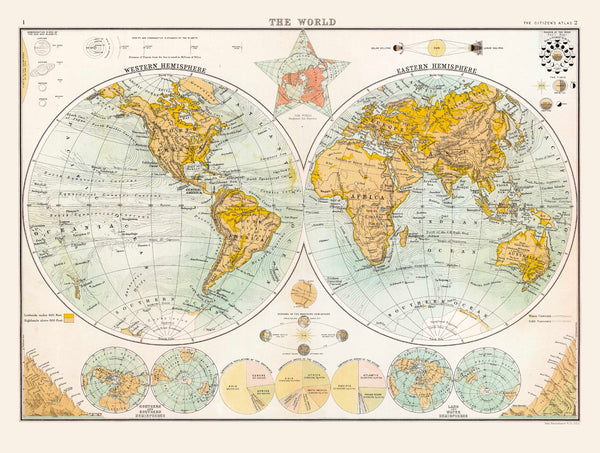
Hold the nineteenth century in two circles. First published in 1898 for The Citizen’s Atlas—engraved by John Bartholomew & Co. for Collins—this full-colour world map presents the Western and Eastern Hemispheres in poised symmetry. Continental and national borders are crisply drawn; surrounding panels set the era’s knowledge in context with astronomical diagrams, comparative charts of the world’s highest mountains, and population statistics. It’s a confident, end-of-century portrait of a world coming into focus—measured, informative, beautifully made.
More Than a Map – A Testament to History
This is not just wall art—it’s a window into how the late-Victorian world understood itself. Every boundary, label and comparative graphic reveals the priorities, curiosities and certainties of 1898. Perfect for historians, educators, collectors, designers, or anyone who loves atlas craft, this map invites study, conversation and context wherever it hangs.
Display it in classrooms, offices, museums, libraries or at home to spark reflection and discovery.
Premium Materials & Finishes
We treat history with the respect it deserves. Choose from premium formats produced with archival methods for beauty that lasts.
🌟 Archival Paper Print
Printed on heavyweight 160gsm archival-grade paper.
Smooth matte finish reduces glare and preserves engraved linework and fine labels—ideal for framing under glass.
💎 Laminated Edition
Encapsulated in two 80-micron gloss laminate sheets using true thermal bonding (not surface film).
Moisture-resistant, wipe-clean surface—perfect for schools, offices and high-traffic spaces.
Optional Natural Timber Hang Rails: lacquered rails with a fitted cord provide a polished, ready-to-hang presentation. (Please allow up to 10 working days for delivery with hang rails.)
🏆 Museum-Quality Canvas
Printed on 395gsm HP Professional Matte Canvas for rich texture and strength.
Pigment-based, fade-resistant inks deliver vibrant colour and crisp lines that endure for generations.
Optional Natural Timber Hang Rails: lacquered to enhance the grain, with a top cord for effortless hanging—timeless and elegant. (Please allow up to 10 working days for delivery with hang rails.)
Specifications
| Feature | Details |
|---|---|
| Original Publication | 1898, The Citizen’s Atlas |
| Publisher/Engraver | John Bartholomew & Co. for Collins |
| Title | Historic Map of the World (1898) |
| Format | Twin hemispheres (Western & Eastern) |
| Surrounds | Astronomical diagrams; comparative highest mountains; population charts |
| Map Size | 816 mm (W) × 624 mm (H) |
| Available Formats | Paper, Laminated, Canvas |
| Paper Weight | 160gsm archival-quality |
| Laminate | 2 × 80-micron gloss sheets (encapsulated) |
| Canvas Weight | 395gsm HP Professional Matte Canvas |
| Inks | Pigment-based, fade-resistant |
| Optional Hang Rails | Available on Laminated & Canvas versions |
| Origin | Made in Australia |
Why Choose This Map
✔ A Fin-de-Siècle Portrait: See the world as atlas makers framed it at the close of the nineteenth century.
✔ Atlas Pedigree: From Collins and John Bartholomew & Co., leaders of Victorian cartography.
✔ Clarity & Context: Twin hemispheres for instant orientation—plus comparative charts that explain the era’s worldview.
✔ Crafted to Last: Premium substrates and archival inks preserve colour and line for decades.
✔ Ready to Display: Optional hang-railed laminated or canvas editions offer a museum-quality look—no framing required.
✔ An Inspired Gift: Mark an anniversary, honour a traveller, or enrich a learning space with a true historical statement piece.
Our Commitment
We believe preserving history is as important as telling it. Every map is printed locally in Australia using state-of-the-art technology, carefully checked by hand, and packed with care. From our workshop to your wall, we ensure quality you can trust and a legacy you’ll be proud to share.
Bring this sweeping nineteenth-century worldview into your space. Order the Historic Map of the World (1898) today—a faithful record of borders, ideas and imagination at the dawn of the modern age.


