- Australia ▾
- Topographic
▾
- Australia AUSTopo 250k (2025)
- Australia 50k Geoscience maps
- Australia 100k Geoscience maps
- Australia 250k Geoscience maps
- Australia 1:1m Geoscience maps
- New Zealand 50k maps
- New Zealand 250k maps
- New South Wales 25k maps
- New South Wales 50k maps
- New South Wales 100k maps
- Queensland 10k maps
- Queensland 25k maps
- Queensland 50k maps
- Queensland 100k maps
- Western Australia 25k maps
- Western Australia 50k maps
- Western Australia 100k maps
- Compasses
- Software
- GPS Systems
- International ▾
- Wall Maps
▾
- World
- Australia & New Zealand
- Countries, Continents & Regions
- Historical
- Vintage National Geographic
- Australian Capital Territory
- New South Wales
- Northern Territory
- Queensland
- South Australia
- Tasmania
- Victoria
- Western Australia
- Celestial
- Children's
- Mining & Resources
- Wine Maps
- Healthcare
- Postcode Maps
- Electoral Maps
- Nautical ▾
- Flags
▾
- Australian Flag Sets & Banners
- Flag Bunting
- Handwavers
- Australian National Flags
- Aboriginal Flags
- Torres Strait Islander Flags
- International Flags
- Flagpoles & Accessories
- Australian Capital Territory Flags
- New South Wales Flags
- Northern Territory Flags
- Queensland Flags
- South Australia Flags
- Tasmania Flags
- Victoria Flags
- Western Australia Flags
- Gifts ▾
- Globes ▾
Dear valued customer. Please note that our checkout is not supported by old browsers. Please use a recent browser to access all checkout capabilities


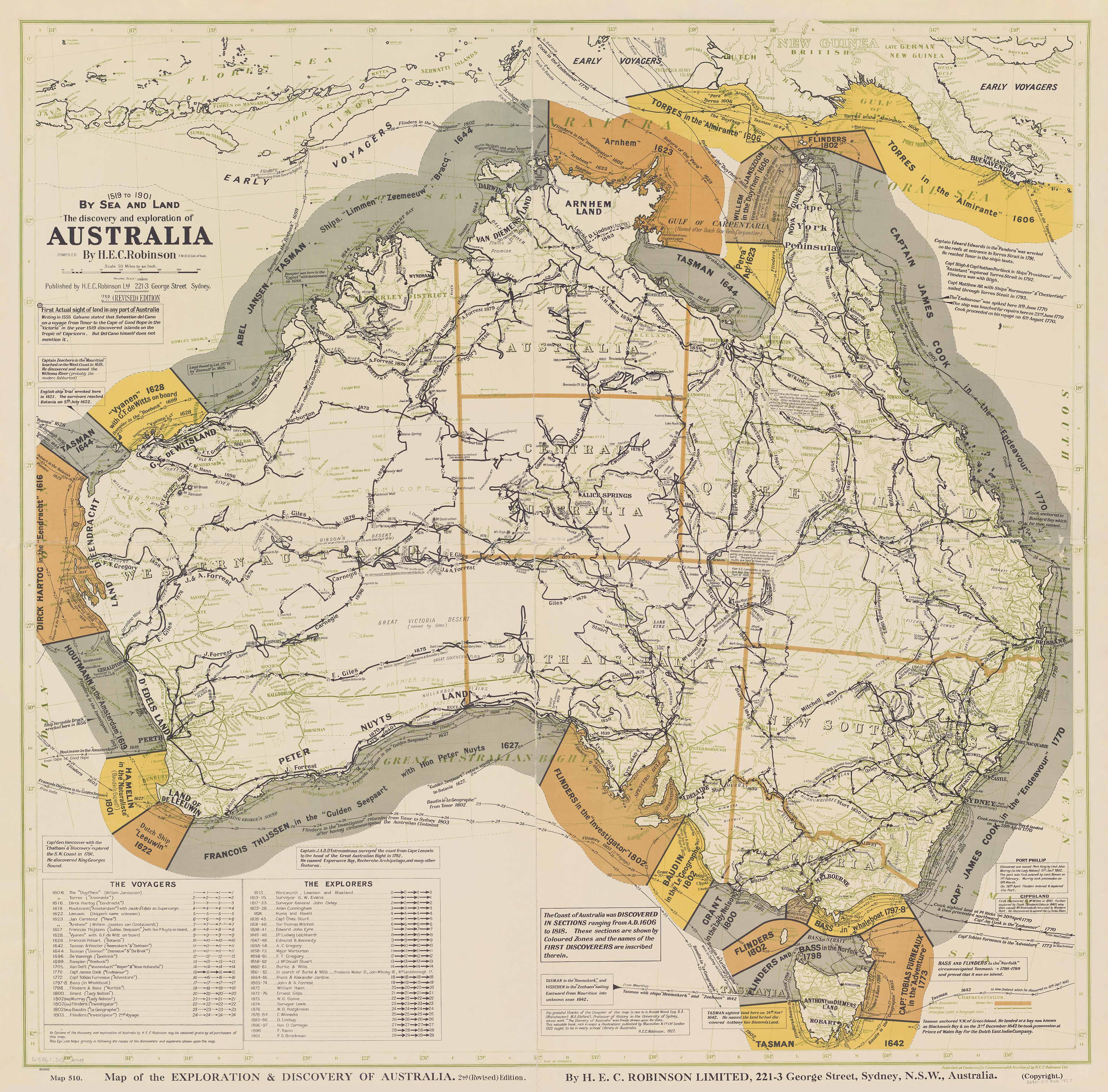
The Discovery and Exploration of Australia, 1519 to 1901 by Sea and Land Wall Map
$69.95
or make 4 interest-free payments of
$17.49 AUD
fortnightly with
![]() More info
More info
A Cartographic Chronicle of Australia's Greatest Journeys — Compiled by H.E.C. Robinson, 1927
This striking historical map offers a fascinating visual account of over 380 years of discovery and exploration across the Australian continent. The Discovery and Exploration of Australia, 1519 to 1901 by Sea and Land is more than a map — it is a tapestry of human ambition, courage, and perseverance.
Originally compiled and published in 1927 by H.E.C. Robinson Ltd., one of Australia's premier early 20th-century mapmakers, this beautifully rendered chart captures the essence of the voyages that charted the unknown southern land — by sea and by foot. The map traces the routes of the earliest European explorers, including Torres, Tasman, Dampier, and Flinders, as well as the inland expeditions of iconic Australian explorers such as Sturt, Mitchell, Leichhardt, Eyre, Burke and Wills, and Giles.
It presents these journeys with grace and clarity, featuring period-specific annotations, ship names, dates, and expedition details — all within a carefully styled decorative border that evokes the golden age of exploration.
🗺️ What Makes This Map Special
-
A sweeping overview of Australia’s early cartographic history, from the first documented maritime sightings in the 1500s through to Federation in 1901
-
Chronicles the most important journeys in Australia’s exploration — by sea and land — showing the year, direction, and path of each expedition
-
Beautiful period design with classic serif fonts, illustrative elements, and historical annotations
-
An evocative reproduction of a rare historic piece, carefully restored to retain its original character while ensuring legibility and clarity
🖼️ Display & Print Options
This vintage map is available in a range of premium-quality finishes to suit your space and style:
🖨️ Heavyweight Matte Art Paper (160 gsm)
Perfect for professional framing, this version is printed on archival-quality FSC-certified matte-coated paper. The muted tones and rich historical detail are preserved beautifully, making it ideal for libraries, offices, or home studies.
💧 Encapsulated Gloss Laminate
Encased between two layers of 80-micron gloss laminate, this version is designed for practical and long-term use in classrooms, public spaces, and historical exhibitions. You can draw on it with whiteboard markers or apply map dots to highlight key routes — all without damaging the surface.
🖼️ Archival-Grade Canvas (395 gsm HP Professional Matte Canvas)
Our premium offering. Printed using long-lasting, fade-resistant pigment-based inks, this option provides a museum-quality finish with fine texture and exceptional clarity. The canvas evokes the feel of the original parchment and is well suited for boardrooms, galleries, universities, or heritage collections.
🪵 Optional Hanging System
Want to display this historic piece as it was meant to be seen? Choose the wooden hang-rail finish for your canvas map. Fitted with top and bottom rails and a discreet hanging cord, this elegant option transforms the map into a statement piece ready to hang from a single hook.
-
Rails are lacquered in a natural timber tone
-
Hanging cord is securely fastened to the upper rail
-
The most stylish way to present your map without a traditional frame
⏳ Please allow 10 working days for delivery of hang-railed canvas maps, as they are finished individually by our professional framer.
📏 Available Sizes
| Format | Dimensions (W × H) |
|---|---|
| Standard | 900 mm × 890 mm |
| Large | 1200 mm × 1180 mm |
Custom sizes may be available on request for institutional or design projects.
🏛️ A True Collector’s Piece
Whether you're a historian, cartographer, educator, collector, or simply someone fascinated by the journey of Australia’s development, this map offers a tangible connection to the past. It represents not only the colonial narrative but also the deepening awareness of the land’s vastness, diversity, and the endurance of those who sought to chart it.
This reproduction is an homage to one of Australia's most defining cartographic achievements — a stunning artefact that invites study, appreciation, and admiration.
Details
-
Title: The Discovery and Exploration of Australia, 1519 to 1901 by Sea and Land
-
Compiler: H.E.C. Robinson Ltd., Sydney
-
Original Publication Year: 1927
-
Printed & Reproduced in: Australia
-
Materials: FSC matte-coated paper / gloss laminate / HP archival canvas
Frequently Asked Questions
What are the dimensions of the The Discovery and Exploration of Australia, 1519 to 1901 by Sea and La?
Mapworld wall maps range from standard 700×1000mm to large-format 1000×1430mm Supermaps. The exact dimensions for this map are shown in the product title. Where multiple sizes are available, select your preferred size when adding to cart.
Is this wall map available laminated?
Many Mapworld wall maps are available in paper, laminated, or framed finishes. Check the product options when adding to cart. Laminated maps are wipe-clean and more durable.
Is this the latest edition?
Mapworld stocks the most current editions available from all publishers. Edition year is shown in the product title where applicable. Mapworld updates its catalogue as new editions are released.
Can I write on or pin this wall map?
Laminated wall maps can be written on with whiteboard markers and wiped clean. Paper maps can be pinned on a corkboard. Choose a laminated option for a writeable surface.
Does Mapworld ship the The Discovery and Exploration of Australia, 1519 to 1901 by Sea and La across Australia?
Yes, Mapworld ships Australia-wide. Standard shipping is a flat $7 rate, with free standard shipping on orders over $75. Express options are available at checkout. Most orders placed before 2pm AEST on weekdays are dispatched same day.
Related Items


© 2026 Mapworld. Website designed by Genie Media
X