- Australia ▾
- Topographic
▾
- Australia AUSTopo 250k (2025)
- Australia 50k Geoscience maps
- Australia 100k Geoscience maps
- Australia 250k Geoscience maps
- Australia 1:1m Geoscience maps
- New Zealand 50k maps
- New Zealand 250k maps
- New South Wales 25k maps
- New South Wales 50k maps
- New South Wales 100k maps
- Queensland 10k maps
- Queensland 25k maps
- Queensland 50k maps
- Queensland 100k maps
- Western Australia 25k maps
- Western Australia 50k maps
- Western Australia 100k maps
- Compasses
- Software
- GPS Systems
- International ▾
- Wall Maps
▾
- World
- Australia & New Zealand
- Countries, Continents & Regions
- Historical
- Vintage National Geographic
- Australian Capital Territory
- New South Wales
- Northern Territory
- Queensland
- South Australia
- Tasmania
- Victoria
- Western Australia
- Celestial
- Children's
- Mining & Resources
- Wine Maps
- Healthcare
- Postcode Maps
- Electoral Maps
- Nautical ▾
- Flags
▾
- Australian Flag Sets & Banners
- Flag Bunting
- Handwavers
- Australian National Flags
- Aboriginal Flags
- Torres Strait Islander Flags
- International Flags
- Flagpoles & Accessories
- Australian Capital Territory Flags
- New South Wales Flags
- Northern Territory Flags
- Queensland Flags
- South Australia Flags
- Tasmania Flags
- Victoria Flags
- Western Australia Flags
- Gifts ▾
- Globes ▾
Dear valued customer. Please note that our checkout is not supported by old browsers. Please use a recent browser to access all checkout capabilities


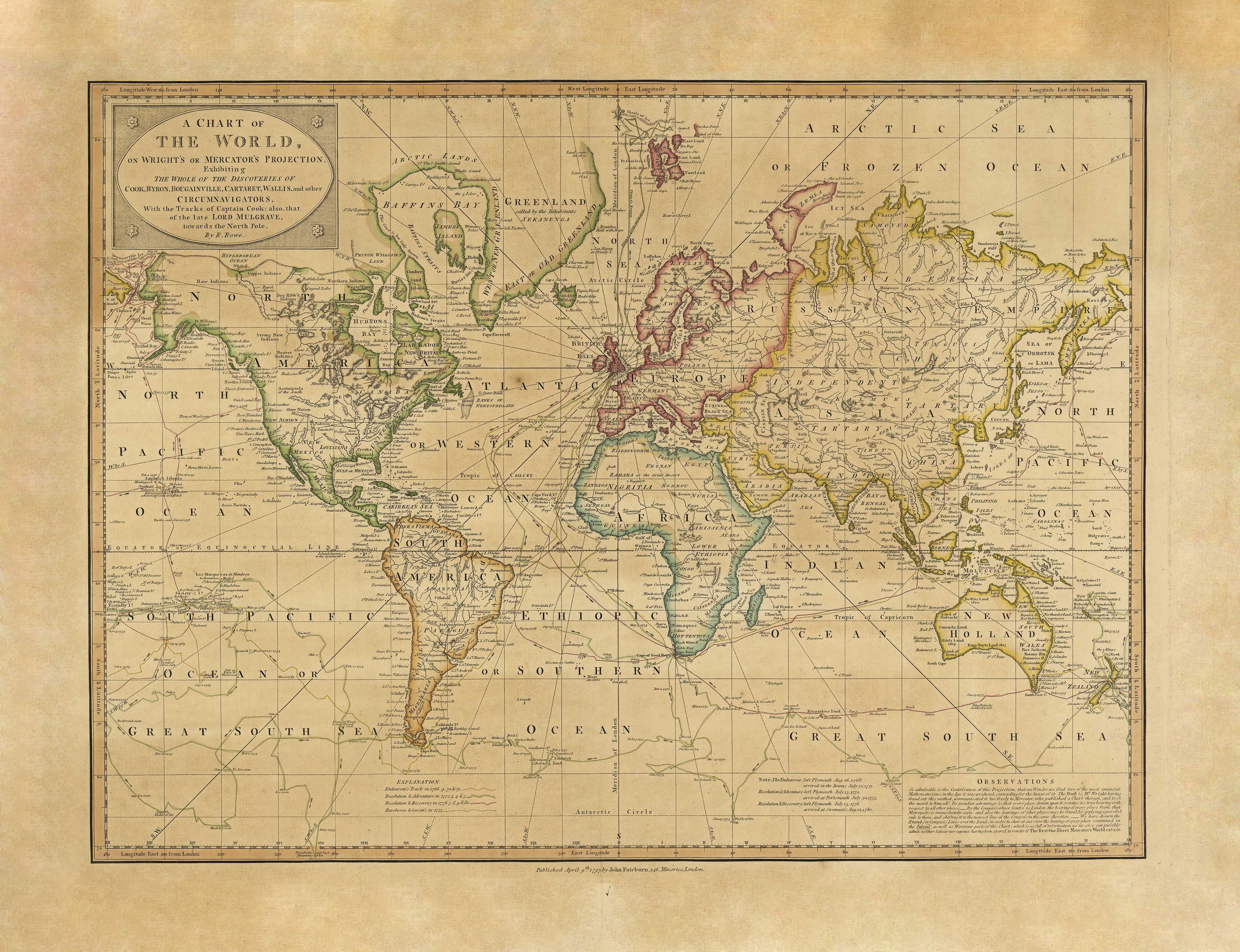
Explorers Map of the World published in 1797
$59.95
or make 4 interest-free payments of
$14.99 AUD
fortnightly with
![]() More info
More info
Featuring the voyages of Cook, Byron, Bougainville and the great circumnavigators
This beautifully reproduced 1797 world map, originally published by John Fairburn and drawn by Robert Rowe (1775–1843), charts the age of exploration in remarkable detail. Titled “A Chart of the World on Wright's or Mercator's Projection,” it captures the known world as understood at the close of the 18th century and showcases the routes of legendary explorers including Captain Cook, Byron, Bougainville, Carteret, Wallis, and Lord Mulgrave on his polar expedition.
This is not just a map—it’s a cartographic record of discovery, ambition, and maritime daring. A rare opportunity to own a visual account of exploration before satellites, steamships, or Suez.
Historical Significance:
-
Projection: Wright's or Mercator’s—allowing for accurate compass bearings, crucial for maritime navigation.
-
Voyages Tracked: Includes the full circumnavigations of Cook and his contemporaries, as well as Arctic routes towards the North Pole.
-
Published: London, 1797, in the midst of the Enlightenment and just years after Cook’s final voyage.
Finishing Options:
| Finish | Description |
|---|---|
| Paper (160 gsm) | Archival-quality heavyweight paper—ideal for traditional framing under glass. |
| Laminated | True encapsulation between two 80-micron gloss laminate sheets. Durable, wipe-clean, and long-lasting—suitable for study or office display. |
| Canvas (395 gsm Matte) | Printed with fade-resistant pigment-based inks on museum-grade canvas. The rich texture and tonal depth elevate this historical map into a gallery-worthy centrepiece. |
Optional Timber Hang Rails (Laminated & Canvas):
For an authentic old-world finish, choose the option with hang rails. Attached top and bottom, the upper rail features a cord for easy hanging. The timber is lacquered in a classic natural finish.
Note: Please allow 10 working days for hang-railed canvas maps, as each is custom-assembled by our professional framer.
Map Specifications:
-
Publication Date: 1797
-
Cartographer: Robert Rowe
-
Publisher: John Fairburn, London
-
Made in: Australia
-
Projection: Mercator
Available Sizes:
| Size | Dimensions |
|---|---|
| Standard | 790 mm (W) × 600 mm (H) |
| Large | 1150 mm (W) × 880 mm (H) |
| Supermap | 1820 mm (W) × 1400 mm (H) |
Whether you’re a collector, historian, or simply an admirer of classic cartography, this map is a remarkable tribute to the age of sail and discovery. Ideal for libraries, studies, or heritage-inspired interiors.
Frequently Asked Questions
What are the dimensions of the Explorers Map of the World published in 1797?
Mapworld wall maps range from standard 700×1000mm to large-format 1000×1430mm Supermaps. The exact dimensions for this map are shown in the product title. Where multiple sizes are available, select your preferred size when adding to cart.
Is this wall map available laminated?
Many Mapworld wall maps are available in paper, laminated, or framed finishes. Check the product options when adding to cart. Laminated maps are wipe-clean and more durable.
Is this the latest edition?
Mapworld stocks the most current editions available from all publishers. Edition year is shown in the product title where applicable. Mapworld updates its catalogue as new editions are released.
Can I write on or pin this wall map?
Laminated wall maps can be written on with whiteboard markers and wiped clean. Paper maps can be pinned on a corkboard. Choose a laminated option for a writeable surface.
Does Mapworld ship the Explorers Map of the World published in 1797 across Australia?
Yes, Mapworld ships Australia-wide. Standard shipping is a flat $7 rate, with free standard shipping on orders over $75. Express options are available at checkout. Most orders placed before 2pm AEST on weekdays are dispatched same day.
Related Items


© 2026 Mapworld. Website designed by Genie Media
X