- Australia ▾
- Topographic
▾
- Australia AUSTopo 250k (2024)
- Australia 50k Geoscience maps
- Australia 100k Geoscience maps
- Australia 250k Geoscience maps
- Australia 1.1m Geoscience maps
- New Zealand 50k maps
- New Zealand 250k maps
- New South Wales 25k maps
- New South Wales 50k maps
- New South Wales 100k maps
- Queensland 10k maps
- Queensland 25k maps
- Queensland 50k maps
- Queensland 100k maps
- Compasses
- Software
- GPS Systems
- Orienteering
- International ▾
- Wall Maps
▾
- World
- Australia & New Zealand
- Countries, Continents & Regions
- Historical
- Vintage National Geographic
- Australian Capital Territory
- New South Wales
- Northern Territory
- Queensland
- South Australia
- Tasmania
- Victoria
- Western Australia
- Celestial
- Children's
- Mining & Resources
- Wine Maps
- Healthcare
- Postcode Maps
- Electoral Maps
- Nautical ▾
- Flags
▾
- Australian Flag Sets & Banners
- Flag Bunting
- Handwavers
- Australian National Flags
- Aboriginal Flags
- Torres Strait Islander Flags
- International Flags
- Flagpoles & Accessories
- Australian Capital Territory Flags
- New South Wales Flags
- Northern Territory Flags
- Queensland Flags
- South Australia Flags
- Tasmania Flags
- Victoria Flags
- Western Australia Flags
- Gifts ▾
- Globes ▾
Dear valued customer. Please note that our checkout is not supported by old browsers. Please use a recent browser to access all checkout capabilities
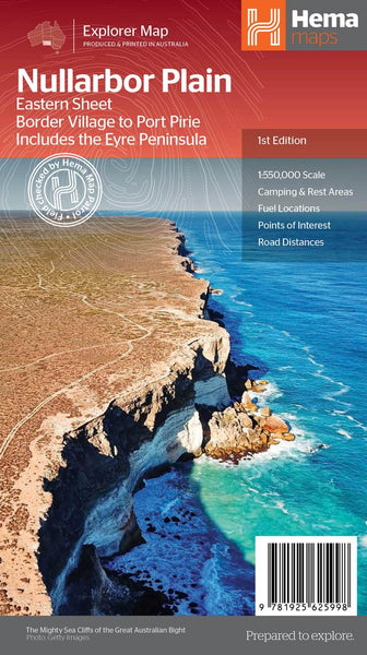
Nullarbor Plain East Hema Map
$14.95 $15.95
Afterpay is only available for orders between $50.00 and $1000.00 More info
Scale: 1:550,000 | Edition: 1st | Covers: Port Pirie to Border Village, including the Eyre Peninsula
Your Essential Guide to Australia’s Great Desert Highway
🚗 Journey Across One of the World’s Greatest Outback Drives
The Nullarbor Plain isn’t just a stretch of road—it’s a rite of passage. A semi-arid wilderness of sun-scorched horizons and deep geological wonder, the Eyre Highway cuts a long, lonely path across this ancient seabed. To do it justice, Hema has created two detailed touring maps: the East Sheet (Port Pirie to Border Village) and the West Sheet (Border Village to Kalgoorlie).
This Nullarbor Plain East Map by Hema is a comprehensive, field-checked guide to the eastern half of the journey—covering South Australia’s Eyre Peninsula, famous roadhouses, desolate beauty, and thrilling 4WD adventures.
Whether you're driving coast-to-coast, exploring the iconic caves and blowholes, or venturing along Googs Track, this map delivers exceptional accuracy, rich detail, and all the planning information you need to take on Australia’s desert frontier.
🧭 Key Features
🛣️ Roads & 4WD Tracks
-
Includes all major sealed and unsealed routes from Port Pirie to Border Village
-
Shows Googs Track and other notable 4WD trails verified by the Hema Map Patrol
-
Road distances clearly marked between key waypoints
⛽ Touring Essentials
-
🏕️ Camping & Rest Areas: Easily locate designated sites and scenic bush camps
-
⛽ Fuel Stops: Know where to fill up before you’re running on empty
-
🏨 Accommodation: Find motels, roadhouses, and outback stations
-
🕳️ Natural Attractions: Explore the Nullarbor caves, remote beaches, and coastal lookouts along the Great Australian Bight
🗺️ Topographic & Heritage Detail
-
Contour shading and elevation profiles to help you plan for terrain
-
Historical notes about the Nullarbor’s unique past and geological significance
-
Ideal for those interested in Indigenous culture, early explorers, and railway heritage
📍 Coverage Area
-
Eastern Nullarbor Plain from Port Pirie through Kimba, Ceduna, Fowlers Bay, to Border Village
-
Full coverage of the Eyre Peninsula, including coastal routes, conservation parks, and minor roads
-
Links seamlessly with Nullarbor Plain West Map for the complete journey across the continent
📏 Product Specifications
| Specification | Details |
|---|---|
| Title | Nullarbor Plain East Touring Map |
| Publisher | Hema Maps Australia |
| Edition | 1st |
| Publication Date | 12 August 2021 |
| Scale | 1:550,000 |
| Format | Folded touring map |
| Size | Standard Hema map size (approx. 1000mm x 700mm unfolded) |
| Language | English |
| Printed in | Australia 🇦🇺 |
🧳 Who This Map Is For
-
🛻 4WD Enthusiasts – Tackle Googs Track, sandy spurs, and isolated inland routes with confidence
-
⛺ Grey Nomads & Caravanners – Plan efficient stops, fuel-ups, and scenic overnight stays
-
🌄 Nature Lovers – Discover caves, salt pans, cliffs, and the otherworldly terrain of the Nullarbor
-
📚 Historians & Curious Travellers – Learn about the region’s Indigenous, colonial, and geological history
-
🗺️ Map Collectors & Overlanders – Add a beautifully detailed and rugged route to your Australian map collection
🛒 Add to Cart – Start Your Great Australian Crossing
This Nullarbor Plain East Map is more than just a navigational tool—it's a story waiting to unfold, kilometre by kilometre. With verified track data, extensive touring info, and a Pacific-centred perspective that gives the Nullarbor its rightful scale, this map is essential for any desert traveller.
Pair it with the Nullarbor Plain West Sheet to complete the transcontinental adventure.
Add to your cart today, and prepare for one of the most iconic outback journeys on Earth.


