- Australia ▾
- Topographic
▾
- Australia AUSTopo 250k (2025)
- Australia 50k Geoscience maps
- Australia 100k Geoscience maps
- Australia 250k Geoscience maps
- Australia 1:1m Geoscience maps
- New Zealand 50k maps
- New Zealand 250k maps
- New South Wales 25k maps
- New South Wales 50k maps
- New South Wales 100k maps
- Queensland 10k maps
- Queensland 25k maps
- Queensland 50k maps
- Queensland 100k maps
- Western Australia 25k maps
- Western Australia 50k maps
- Western Australia 100k maps
- Compasses
- Software
- GPS Systems
- International ▾
- Wall Maps
▾
- World
- Australia & New Zealand
- Countries, Continents & Regions
- Historical
- Vintage National Geographic
- Australian Capital Territory
- New South Wales
- Northern Territory
- Queensland
- South Australia
- Tasmania
- Victoria
- Western Australia
- Celestial
- Children's
- Mining & Resources
- Wine Maps
- Healthcare
- Postcode Maps
- Electoral Maps
- Nautical ▾
- Flags
▾
- Australian Flag Sets & Banners
- Flag Bunting
- Handwavers
- Australian National Flags
- Aboriginal Flags
- Torres Strait Islander Flags
- International Flags
- Flagpoles & Accessories
- Australian Capital Territory Flags
- New South Wales Flags
- Northern Territory Flags
- Queensland Flags
- South Australia Flags
- Tasmania Flags
- Victoria Flags
- Western Australia Flags
- Gifts ▾
- Globes ▾
Dear valued customer. Please note that our checkout is not supported by old browsers. Please use a recent browser to access all checkout capabilities


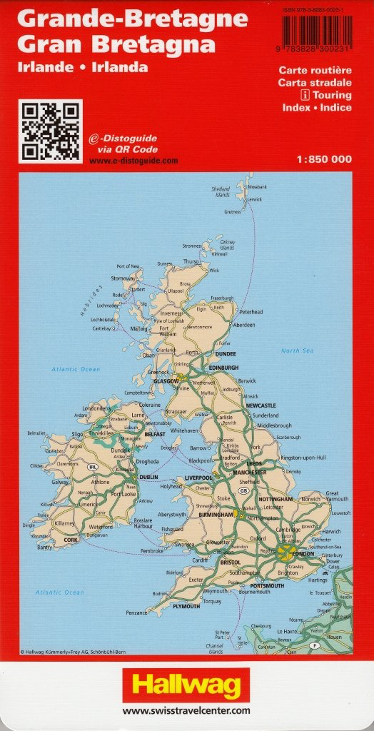
Great Britain & Ireland Hallwag Map
Sold Out
Afterpay is only available for orders between $50.00 and $1000.00 More info
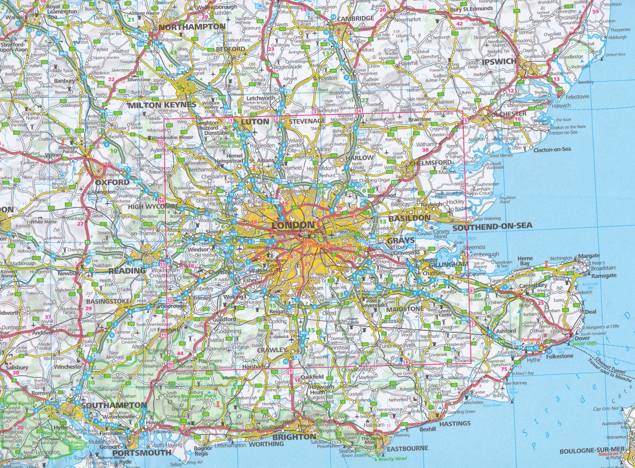
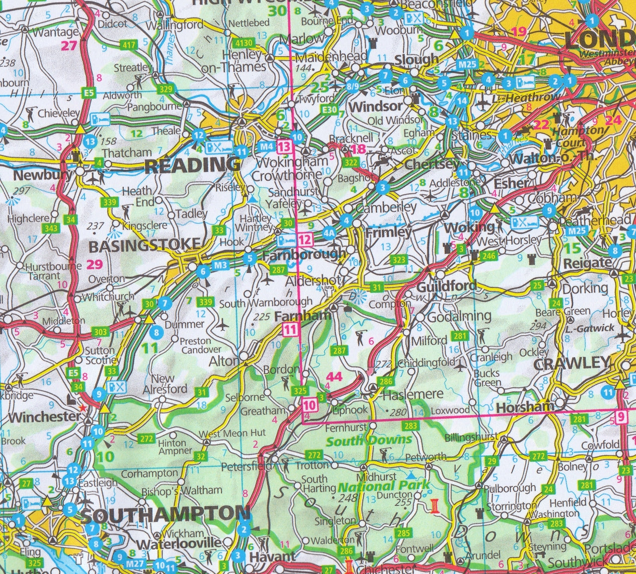
Discover the entirety of Great Britain and Ireland at a glance with this comprehensive, beautifully printed map from Hallwag—one of Europe’s most respected cartographic publishers.
Whether you're planning a scenic road trip across the Highlands, tracing your family roots through rural Ireland, or simply decorating your study with something that inspires adventure, this one-sheet, large-format map offers the perfect blend of clarity, usability, and beauty.
🔍 Why This Map Stands Out
A Complete View of the British Isles
This is not a patchwork of separate panels or regions—this is the entire United Kingdom and Republic of Ireland on one seamless side. It includes:
-
England
-
Scotland
-
Wales
-
Northern Ireland
-
The Republic of Ireland
-
Isle of Man & key offshore islands
With one look, you’ll understand the geography, scale, and interconnectivity of the region—perfect for everything from cross-country travel planning to academic presentations.
🛣️ Perfect for Travellers & Planners
Planning a trip across the UK or Ireland? This map has you covered with a scale of 1:850,000, which is ideal for medium-range travel planning. It clearly presents:
-
Major highways, motorways & regional roads
-
National routes, scenic byways, and ferry links
-
Clear distance markers and major border crossings
-
Logical, uncluttered cartography that’s easy to follow—even at a glance
Whether you’re driving from London to the Lakes, touring Ireland’s Wild Atlantic Way, or connecting small towns and villages, this map brings confidence to every kilometre of your journey.
📐 Specifications:
| Feature | Detail |
|---|---|
| Scale | 1:850,000 – perfect for route planning |
| Size | 1300 mm wide × 1000 mm high |
| Print Format | Single-sided |
| Edition | Folded paper map |
| Material | High-quality paper stock |
| Languages | English |
| Brand | Hallwag International |
| Digital Link | NONE |
🌍 Who Is This Map For?
This isn’t just for map collectors. This is for anyone who wants to see the big picture, stay organised, or simply celebrate a love of the British Isles:
-
✈️ International travellers planning a grand UK–Ireland adventure
-
🚐 Vanlifers and motorhome travellers plotting scenic routes
-
🧑🏫 Educators and geography students using visual learning tools
-
🎁 Gift buyers looking for a practical and thoughtful present for travel lovers
-
📚 Historians or genealogy researchers mapping family roots and movements
🖼️ Wall Art Meets Practical Utility
While this map is designed to be folded and stored, its size (1300 x 1000 mm) makes it a striking display piece. Whether framed in an office, pinned in a classroom, or hung in a caravan, it brings a sense of place—and potential—to any space.
Want it mounted or laminated? Ask us about framing or custom finishing options.
📦 Shipping & Presentation
-
✅ Ships folded in a durable protective sleeve
-
📬 Available for fast dispatch Australia-wide
-
📦 Bulk and wholesale orders available upon request
-
🛡️ Protective packaging ensures it arrives ready to use or gift
💬 What Customers Say
“I bought this for our campervan trip through the UK and Ireland and it was a total game changer. No more scrolling or zooming on phones. This map gave us a real sense of distance and direction.”
— ★★★★★ Verified Customer
“Beautifully printed, with incredibly useful info. I’m framing it for my office. It’s both a conversation starter and a planning tool.”
— ★★★★★ Verified Buyer
🧭 Ready to Explore?
From the windswept moors of Yorkshire to the emerald coasts of Kerry, the Hallwag Great Britain & Ireland Map lets you see the whole journey—before you’ve even left home.
Elegant, detailed, and utterly practical, it’s the kind of map you’ll return to again and again—whether to plan, remember, or simply dream.
Frequently Asked Questions
Where can I buy the Great Britain & Ireland Hallwag Map?
The Great Britain & Ireland Hallwag Map is available to buy online from Mapworld, Australia's largest map and geographic product retailer, with fast shipping Australia-wide.
Is the Great Britain & Ireland Hallwag Map in stock at Mapworld?
Mapworld maintains extensive stock across its map range and aims for fast dispatch. Orders placed before 2pm AEST on business days are typically dispatched the same day, with standard and express Australia-wide delivery options available.
What is Mapworld's returns policy?
Mapworld accepts returns on undamaged items in original condition. Contact Mapworld within 90 days of purchase to arrange a return or exchange.
Does Mapworld ship the Great Britain & Ireland Hallwag Map across Australia?
Yes, Mapworld ships Australia-wide. Standard shipping is a flat $7 rate, with free standard shipping on orders over $75. Express options are available at checkout. Most orders placed before 2pm AEST on weekdays are dispatched same day.
Related Items


© 2026 Mapworld. Website designed by Genie Media
X